|
AVSIM Library - Search Results
|
|
Login | Register | About logging in and out
|
|
Searching for: 'vectors' in Flight Simulator X - Scenery and below.
|

|
|
|
|
|
|
Other files which are related to, or may be required by, this file:
Images related to this file:
|
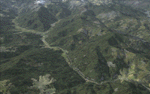
File Description:
This project adds and updates all of the airports of Bhutan. Bathpalathang (VQBT) and Gelephu (VQGP) are added, Yongphulla (VQ10) is updated and recoded as VQTY, and Paro (VQPR) is fully updated to reflect current satellite imagery. These are all fully functioning AI airports as well. Special attention was given to the entire Paro Valley, and numerous road/river vectors were updated around Gelephu. Accurate coastlines, lakes, road and river data, as well as corrected landclass are provided based on the latest available satellite imagery. They are optimized to fit seamlessly with FTX Vector's roads/water, but they should be fully functional in all FSX configurations.
GA-encoded flight plans for the Buddha Air/Kathmandu charter are provided to enhance service to Paro. NASA SRTM Global 3 arc second terrain mesh is also included for all of Bhutan. Updates were created or rebuilt in a manner which carefully aligned airport data with current satellite imagery, when available. Scenery was created using Airport Design Editor X v1.61.5298, SBuilderX 3.13, and the FSX Object Placement Tool. Scenery objects were added and modified from stock FSX scenery to resemble as closely as possible the actual airports.
|
| Filename: |
bhutan_airports_and_paro_valley.zip |
| License: |
Freeware |
| Added: |
19th January 2015, 06:09:17 |
| Downloads: |
10771 |
| Author: |
Carlyle Sharpe |
| Size: |
21861kb |
|
|
Images related to this file:
|
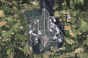
File Description:
This is my first Photoscenery Scenery.
This is the Airport of Neuhausen ob Eck in Southern Germany.
I added some houses,hangars and trees to this scenery and vectors for GPS Approach on both runways.
|
| Filename: |
edsn.zip |
| License: |
Freeware |
| Added: |
7th October 2012, 14:52:15 |
| Downloads: |
1139 |
| Author: |
Oliver Braun |
| Size: |
9473kb |
|
|
|
Other files which are related to, or may be required by, this file:
Images related to this file:

|
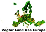
File Description:
Vector land use data processed from EEA Corine Land Cover 2006 data (European Environment Agency). This add-on doesn't cover sea, ocean, water bodies, waterways or streams. Only dry land vectors are included. Download and install Vector Land Use Europe 2 to get the most out of this add-on.
|
| Filename: |
land_use_europe_1.zip |
| License: |
Freeware, limited distribution |
| Added: |
20th May 2014, 22:49:16 |
| Downloads: |
2654 |
| Author: |
Sami Toronen |
| Size: |
446328kb |
|
|
Other files which are related to, or may be required by, this file:
Images related to this file:
|
File Description:
Vector land use data processed from EEA Corine Land Cover 2006 data (European Environment Agency). This add-on doesn't cover sea, ocean, water bodies, waterways or streams. Only dry land vectors are included. Download and install Vector Land Use Europe 1 to get the most out of this add-on.
|
| Filename: |
land_use_europe_2.zip |
| License: |
Freeware |
| Added: |
20th May 2014, 22:49:29 |
| Downloads: |
2260 |
| Author: |
Sami Toronen |
| Size: |
365533kb |
|
  |


