|
AVSIM Library - Search Results
|
|
Login | Register | About logging in and out
|
|
Searching for: 'tim barnes' in Flight Simulator X - Scenery and below.
|

|
|
|
|
|
|
File Description:
These file supersedes all my previous BOP Islands releases and was re-uploaded due to the AVSIM hack- It contains all of the 4 BOP Island releases (including the High Resolution Whale Island aerial and mesh).
Sceneries contain autogenned aerial images, placed objects, effects and runways where appropriate in order to increase the realism of these Islands off the coast of New Zealand.
| Filename: |
bopislands_redux.zip |
| License: |
Freeware, limited distribution |
| Added: |
17th April 2010, 19:38:50 |
| Downloads: |
1645 |
| Author: |
Tim Barnes |
| Size: |
56855kb |
|
|
File Description:
Coromandel airstrip (ICAO: NZCX) is a small airstrip serving the township of Coromandel on the Coromandel Peninsula in New Zealand. It is a grass strip with an offset threshold giving a usable length of 623m. It isn�t lit and fuel is not available.
This scenery includes fully custom hanger, signs and fences, placed library objects and updated facility/runway information.
| Filename: |
coromandelaerodrome.zip |
| License: |
Freeware, limited distribution |
| Added: |
7th May 2008, 11:46:40 |
| Downloads: |
3080 |
| Author: |
Tim Barnes |
| Size: |
522kb |
|
|
|
Other files which are related to, or may be required by, this file:
File Description:
Hi Res Whale Island Scenery: FIX
The bgl file included in this zip is needed to fix a problem with the flatten bgl included with the original download (BopIslands_WhaleHiRes.zip)
Without this file, the water around the Island (one LOD 11 tile) will appear as a desert)
| Filename: |
bopislands_whalehires_patch.zip |
| License: |
Freeware, limited distribution |
| Added: |
16th August 2007, 01:05:16 |
| Downloads: |
2993 |
| Author: |
Tim Barnes |
| Size: |
1kb |
|
|
File Description:
This download contains fully customised Gmax buildings and objects (with glass reflections, no night textures), phototrees, updated facility information and placed library objects.
Kaipara Flats (ICAO: NZKF) is a small airstrip west of Warkworth, a township north of Auckland in New Zealand. It is a grass strip with an offset thresholds giving a useable length of 839m, width of 30m and a group rating of 6. The runway is aligned 07/25. It isn�t lit and AvGas 100 fuel is available.
I decided to model it after doing a roadtrip north of Auckland and taking lots of reference photos of the smaller airfields suitable for the size of aircraft I fly in real life. I am also planning to model SpringHill and Parakai aerodromes in the near future
The airstrip makes a perfect stopping point for training flights around the Auckland region with Ardmore and Northshore aerodromes to the south, Springhill to the north, and Parakai to the west
| Filename: |
kaiparaflats.zip |
| License: |
Freeware, limited distribution |
| Added: |
24th April 2009, 23:56:22 |
| Downloads: |
1596 |
| Author: |
Tim Barnes |
| Size: |
2396kb |
|
|
Category: Flight Simulator X - Scenery
|
|
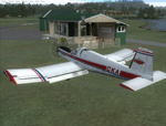
Kiwi360 (KiwiFruit Country)- Custom buildings, helipad, Hi Res photoreal, Aerius R22 Repaint. Te Puke, New Zealand
|


|
File Description:
Kiwi360 (formally know as Kiwifruit Country) is a theme park based around the Kiwifruit (AK.A Chinese Gooseberry or Zespri- The trade name) which is a major export of New Zealand grown predominately in the Bay of Plenty Region. The park is situated about midway between Tauranga and Whakatane, about 5km east of the township of Te Puke.
The Bay of Plentys sunny climate ensures good growing conditions for the delicious fruit and has also spawned a mini tourist industry of tours of the orchards and sorting/packing/coolstores. These include tourist flights by Aerius (http://www.aerius.co.nz ) using a Robinson R44 helicopter.
This scenery was made after a visit when carrying out a GPS survey: I took a few photos and whacked it up. It isn't perfect but will be useful for flights in small helos (I.e. Robinson R22, R44 or Hughes 300/269).
It includes the famous giant Kiwifruit slice, the helipad next to it; the main Kiwi 360 building; a large coolstore/packhouse and the backpackers next to the park. It also includes a lot of library objects (especially trees- If these are adversely affecting performance, you can disable this bgl)
This is placed on a high resolution aerial photo provided by Environment Bay of Plenty.
The scenery also has reflection maps and night maps for those who like getting up at the crack of dawn or simulating frost protection work (although I don't believe the pad is certified for night operations in real life).
The download also includes a repaint of the default Robinson R22 in the colours of ZK-HJZ (in actual fact an R44) kindly provided by James Eden from the ARNZ Forums (see the readme for the .cfg entry to add this repaint)
This helipad isn't in controlled airspace but Tauranga Tower is nearby and will need to be called before entering their airspace (above 2500ft LL for the CTA or within about 10nm of Tauranga for the CTZ) Radio procedures are carried out on Christchurch Information 125.5 for flight following/planning.
| Filename: |
kiwi360.zip |
| License: |
Freeware, limited distribution |
| Added: |
29th June 2008, 06:05:29 |
| Downloads: |
2430 |
| Author: |
Tim Barnes, James Eden |
| Size: |
12036kb |
|
|
Images related to this file:
|
File Description:
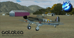
Welcome to Galatea (ICAO: NZGA), a gateway to exploring the Urewera ranges and the east coast of New Zealand. Galatea is a small and basic airstrip with only one old hanger, a public toilet and a small clubhouse on a wide plain surrounded by native bush and pine plantation near Murupara in the Bay of Plenty of New Zealand. It is a grass strip of 1025m length and 60m width and aligned 01/19 with a group rating of 8. No night lighting or fuel is available.
The FSX model includes custom textures and models placed on an aerial image. It makes extensive use of items from the free VLC object libraries which are required to be installed (download from www.vectorlandclass.co.nz downloads menu). This scenery and the VLC libraries have been funded
by sales of VectorLandClass and although you do not need VLC to use it, your purchase helps further development.
To the south west of Murupara township and sawmill is the LakeLand Helicopters base which just fits onto the photo-real coverage. Library objects have been placed here although they may not be accurate as the site was not visited when taking reference photos. This airfield makes a great stop over when flying between Rotorua, Mount Tarawera, Whakatane or Gisborne.
We hope you enjoy exploring the area!
|
| Filename: |
vlc_galatea_install.zip |
| License: |
Freeware, limited distribution |
| Added: |
15th November 2012, 23:35:42 |
| Downloads: |
1088 |
| Author: |
Tim Barnes / VectorLandClass |
| Size: |
46806kb |
|
|
Images related to this file:
|
File Description:
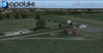
Opotiki aerodrome (ICAO: NZOP) is a small airstrip outside the township of of Opotiki, the gateway to the beautiful East coast of the North Island of New Zealand. Opotiki itself sits at the confluence of the Waioeka and Otara rivers and is surrounded by dairy farmland and Kiwifruit orchards with large areas of native bush to the south and east.
This scenery accompanies Tim Barnes'�� series of other small Bay of Plenty aerodromes (Whakatane,
Galatea, Waihi Beach) for use with VectorLandClass- It features custom modelled and textured buildings, large coverage of beautiful 0.5m aerial photography (fully auto-genned and including seasonal and night variations) and extensive use of high quality objects from the free VLC library. Installation of the library V1.1+ is required for this scenery to work properly and can be downloaded from the VectorLandClass website (www.vectorlandclass.co.nz)
This release, although not requiring it, works best with VectorLandClass topographic mesh and landclass addon covering all 268676 square kilometers of New Zealand. If you'��re not a VLC customer, you'��ll notice when the photoreal coverage runs out!
|
| Filename: |
vlc_opotiki.zip |
| License: |
Freeware, limited distribution |
| Added: |
21st February 2013, 13:52:47 |
| Downloads: |
939 |
| Author: |
Tim Barnes |
| Size: |
150224kb |
|
|
Images related to this file:
|
File Description:
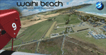
Waihi Beach (ICAO: NZWV) is a small airstrip north of Tauranga and near the small beach settlement of the same name, in the Bay of Plenty of New Zealand. It is a grass strip with offset thresholds giving usable landing lengths of 640m and 517m for RWY 13 and 31 respectively, a width of 55m and a group rating of 5. No night lighting or fuel is available. A very basic airstrip, there is only one recently built hanger and the airstrip is slowly being encroached on by
new housing developments. The airstrip itself is usually very sodden due to its low elevation but is a nice stop over for sightseeing from Tauranga and up the Coromandel peninsula.
The FSX model includes custom textures and models placed on a high resolution aerial image and a 15m mesh. It makes extensive use of items from the free VLC object libraries which are required to be installed (Available from www.vectorlandclass.co.nz Downloads menu). This scenery and
the VLC libraries have been funded by sales of VectorLandClass and although you do not need VLC to use it, your purchase helps further development.
|
| Filename: |
vlc_waihibeach_install.zip |
| License: |
Freeware, limited distribution |
| Added: |
1st November 2012, 10:01:38 |
| Downloads: |
979 |
| Author: |
Tim Barnes / VectorLandClass |
| Size: |
11402kb |
|
|
File Description:
This FSX scenery contains custom models of the main heritage buildings in the Goverment Gardens in the Tourist city of Rotorua, New Zealand.
This scenery release includes:
Custom Models of:
The Bath House (A.k.a The Rotorua Museum)
The Blue Baths
The �Tea Rooms�
The Gardeners Quarters
A Lawn Bowls/Croquet Building
The Rotorua District Council Chambers
The Rotorua Convention Centre
High Resolution Aerial Photograpy covering the Gardens (Summer, Daylight only)
Default trees
Autogen
| Filename: |
governmentgardens.zip |
| License: |
Freeware, limited distribution |
| Added: |
26th November 2007, 04:30:34 |
| Downloads: |
3141 |
| Author: |
Tim Barnes |
| Size: |
6343kb |
|
|
Other files which are related to, or may be required by, this file:
Images related to this file:
|
File Description:
SpringHill (ICAO: NZSL) is a small airstrip between Warkworth and Wellsford, north of Auckland in New Zealand. It is privately owned tarseal strip with offset thresholds giving usable landing lengths of 680m and 700m for RWY 16 and 34 respectively, a width of 10m and a group rating of 5. The runway is aligned 16/34. The tar seal strip is supplemented by a grass strip of the same length but 30m wide. No night lighting or fuel is available.
I decided to model it after doing a roadtrip north of Auckland and taking lots of reference photos of the smaller airfields suitable for the size of aircraft I fly in real life. I am also planning to model Parakai aerodrome in the near future and Kaipara flats has already been modelled.
It contains fully custom Gmax buildings and phototextures.
|
| Filename: |
springhill.zip |
| License: |
Freeware, limited distribution |
| Added: |
28th December 2009, 11:49:01 |
| Downloads: |
1120 |
| Author: |
Tim Barnes (Visualise IT) |
| Size: |
1159kb |
|
  |
