|
AVSIM Library - Search Results
|
|
Login | Register | About logging in and out
|
|
Searching for: 'colorado' in Flight Simulator 2004 - Scenery and below.
|

|
|
|
|
|
|
File Description:
This project adds the ski trails to Crested Butte Mountain, Colorado. This scenery will look best when combined with "FSGenesis-The Rockies 38.2m Terrain Mesh-Colorado" available as "fsg_dem38m_usrk_co.zip" at avsim.com, or comparable mesh. The free FSGenesis US National Landclass Project Beta 6 also adds beautifully to the landscape. Made with Ground2K4 v5.33, by Christian Fumey.
| Filename: |
crested_butte_ski_area.zip |
| License: |
Freeware |
| Added: |
11th June 2004, 19:48:37 |
| Downloads: |
2359 |
| Author: |
Carlyle Sharpe |
| Size: |
149kb |
|
|
Images related to this file:
|
File Description:
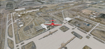
Denver (KDEN), Colorado, Photo-Scenery for FS9 & FSX.
This package covers Denver, the capital of Colorado which is also nicknamed Mile-High City because its elevation is one mile (5.280 ft). The sixth RW (16R/34L) of Denver Int'l. Airport (KDEN) is the longest commercial RW in the US with a length of 16.000ft. This allows fully loaded B747's to take off in Denvers mile-high altitude during hot summer days, when density altitudes can approach 9.000(!) ft.
KDEN is a major hub for United Airlines and the headquarters for Frontier Airlines. The airports distinctive white tent-like fabric roof is designed to be reminiscent of the snow-covered peaks of the Rocky Mountains which you can see on approach or departure.
Other important airports covered by this region are Centennial Airport (KAPA), Buckley AFB (KBKF) and Rocky Mountain Metropolitan Airport (KBJC). Extends my Mt.Evans/Georgetown package to the east and provides another 3.500 sq km in 4.7m/pix quality.
High resolution versions for FS9 and FSX (much sharper, but larger and multiple downloads) are available at www.blueskyscenery.com/GNB_SouthEast.html
. The screenies are taken from the high-res versions, so expect this version to be slightly more blurry. YourDonation@Work: Dedicated to Mark and Charles. Thanks!
|
| Filename: |
gnb_southeast2009_lr.zip |
| License: |
Freeware, limited distribution |
| Added: |
31st October 2009, 11:24:39 |
| Downloads: |
7096 |
| Author: |
Gottfried Razek, blueskyscenery.com |
| Size: |
97493kb |
|
|
|
File Description:
Centennial airport has default was horrible originally. It has more improvement in detail. General Aviation is the busiest airport.
| Filename: |
kapa.zip |
| License: |
Freeware |
| Added: |
2nd November 2020, 18:40:59 |
| Downloads: |
262 |
| Author: |
Stuart John Gilbert II |
| Size: |
2831kb |
|
|
File Description:
FS2004 Scenery-Durango-La Plata County Airport (KDRO)serves Durango and La Plata County in Colorado and is owned by Durango City/La Plata County. The paved runway extends for 9201 feet. The facility is at an elevation of 6685 feet at a distance of about 10 miles from Durango. Created with EZ Scenery and Lago FSE. EZ Scenery libraries required. Lago optional. By John B. Loney, Jr.
| Filename: |
kdro_v1_202483.zip |
| License: |
Freeware |
| Added: |
18th December 2006, 03:45:44 |
| Downloads: |
1595 |
| Author: |
John B. Loney, Jr. |
| Size: |
590kb |
|
|
Images related to this file:
|
File Description:
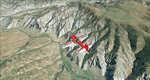
To explore this region depart from Eagle County Regional Airport (KEGE) which is a popular regional airport used in winter to transport skiers to nearby Vail. Northwest of the airport you can see the pit gypsum mine of American Gypsum which produces a variety of wallboard products. When you fly to the west and along the Eagle River, you soon pass its confluence with the Colorado River. Further west you can fly along Glennwood Canyon and finally reach Glennwood Springs where the Colorado meets the Roaring Fork River. Here you can turn south and fly direct Glenwood Springs Airport (KGWS) which lies south of the city. This scenery brings you another 3.500 sq km of beautiful Colorado in 4.7m/pix quality.
High resolution versions of this scenery for FS9 and FSX (much sharper, but larger and multiple downloads) are available at www.blueskyscenery.com/GNB_SouthWest2.html . The screenies are taken from the high-res versions, so expect this version to be slightly more blurry. YourDonation@Work: Dedicated to Alain and James.
|
| Filename: |
gnb_southwest2_2010_lr.zip |
| License: |
Freeware, limited distribution |
| Added: |
30th January 2010, 17:01:49 |
| Downloads: |
2648 |
| Author: |
Gottfried Razek - blueskyscenery.com |
| Size: |
96052kb |
|
|
File Description:
Evergreen, CO is a beautiful little mountain community in the Rocky Mountain foothills (just west of Denver). This scenery and landclass adds the lake in Evergreen, the golf course and also adds the landclass for Kittredge and Morrison (nearby towns). Take a look at the pictures (the town doesn't even exist in the default FS2004).
| Filename: |
evergreen.zip |
| License: |
Freeware |
| Added: |
24th August 2003, 02:56:10 |
| Downloads: |
2255 |
| Author: |
Chris Klein |
| Size: |
212kb |
|
|
File Description:
FS2004 EZ Scenery CASS FIELD (00CO)
Briggsdale Colorado and surrounding parts of Eastern Co are well known for seeds. Seeds of almost any
kind imaginable like flowers, potatoes, bird seed and the list goes on and on. It is most always windy for there are no trees to slow the flow. Hot & windy in summer, cold and windy in winter and no natural enviromnent to harm plant growth. You can see the mountains to the west and more desolation to the east. A lonely place to drive through but rich in good people and seeds harvested for the world.
Area outside of airport's default flatten area require FS Global or Abasus extreme landscapes for elevation data. Download FREE library of RWY12 - EZ scenery objects (available on FlightSim.com or AVSIM) for objects. Ultimate Terrain USA for detailed landclass. FSX compatable.
Instructions inside.
jimmy R martin
| Filename: |
jrm_00co.zip |
| License: |
Freeware |
| Added: |
6th June 2006, 01:54:47 |
| Downloads: |
611 |
| Author: |
jimmy R martin |
| Size: |
255kb |
|
|
Images related to this file:
|
File Description:
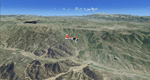
Fremont County, Colorado, Photo-Scenery (FS9 & FSX)
Covers the gap between my Buena Vista and Colorado Springs South sceneries and provides you with continuous coverage for longer cross country flights. High resolution versions of this scenery for FS9 and FSX (much sharper, but larger and multiple downloads) are available at www.blueskyscenery.com/GNB_South3.html . The screenies are taken from the high-res versions, so expect this version to be slightly more blurry. YourDonation@Work: Dedicated to Senges and Dennis.
|
| Filename: |
gnb_south3_2010_lr.zip |
| License: |
Freeware, limited distribution |
| Added: |
13th February 2010, 14:33:42 |
| Downloads: |
1301 |
| Author: |
Gottfried Razek, blueskyscenery.com |
| Size: |
94323kb |
|
|
File Description:
FS2004 Scenery-Fort Collins-Loveland Municipal Airport, Colorado (KFNL) serves Fort Collins/Loveland and Larimer County and is owned by Fort Collins & Loveland. The airport has more than one runway. The longest is a paved runway extending 8500 feet. The facility is at an elevation of 5016 feet at a distance of about 9 miles from Fort Collins/Loveland. Fort Collins-Loveland Municipal Airport is mostly used for general aviation but is also served by one commercial airline, Allegiant Air. This scenery is not an attempt to be picture accurate. Requires the EZ scenery libraries. Read the readme file for list. Lago's FSE optional. By John B. Loney, Jr.
| Filename: |
kfnl_v1.zip |
| License: |
Freeware |
| Added: |
4th December 2006, 20:21:25 |
| Downloads: |
1267 |
| Author: |
John B. Loney, Jr. |
| Size: |
835kb |
|
|
File Description:
FS2004 - Scenery Grand Junction Regional Airport (Walker Field) (IATA: GJT, ICAO: KGJT, FAA LID: GJT) is a public airport located three miles (5 km) northeast of the central business district of Grand Junction, a city in Mesa County, Colorado, United States. The airport covers 2,357 acres (9.5 km˛) and has two runways. It is the largest airport in western Colorado. This Scenery is compatible with both FS9 default and Ultimate Terrain. Created using Instant Scenery by John B. Loney, Jr.
| Filename: |
kgjt_v1.zip |
| License: |
Freeware, limited distribution |
| Added: |
11th September 2008, 00:10:25 |
| Downloads: |
1649 |
| Author: |
John B. Loney, Jr. |
| Size: |
1178kb |
|
  |


