|
AVSIM Library - Search Results
|
|
Login | Register | About logging in and out
|
|
Searching for: 'china' in Flight Simulator X - Scenery and below.
|

|
|
|
|
|
|
Images related to this file:
File Description:
I wanted to create this scenery of China titled "The Door of Paradise" near Zhangjiajie town, Hunan province, and on top of a mountain there is a striking thirty-meter-deep, deep arch rock-shaped cave , Which scales toward the sky. This unique, rocky rock formation seems to date back to the year 263, when - following a catastrophic event - the back of a cave collapsed leaving a hole in the wall and creating this striking panorama that the Chinese call "the symbol closest to God on earth. " I recommend that you leave Zhangjiajie ZGDY airport and reach the Tianmen Mountain coordinates N 29.03.24 E 110.28.58 where you can watch the door l Paradiso.
For more information on the site search on google. In the Package you will also find instructions for installing the scenery.
| Filename: |
porta_del_paradiso.zip |
| License: |
Freeware |
| Added: |
17th August 2017, 17:19:37 |
| Downloads: |
706 |
| Author: |
Pasquale Marrulli |
| Size: |
17313kb |
|
|
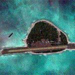
Images related to this file:
|
File Description:
Pagasa Island is a jewel in the South China Sea. It is the one pictured - an emerald splash in an azure sea slashed by a coral runway - whenever new collisions or confrontations are reported in the news for the region. Occupied continuously by the Philippines since 1971, historical use dates back to the Han dynasty, which many believe forms the basis of the Chinese claim to the island. Each country has it's own interpretation of international law and the Filipinos are clearly banking on the precedence of continuous occupation, at no small expense, as Rancudo Field is the farthest airport from Manila within the Philippine sphere of control.
Surprisingly, the geography of the island serves to capture and retain rainwater, although the aquifer is stagnant and the water must be treated for consumption. Sea life remains abundant, poachers take coral heads and sea turtles. There is a solar farm and recently installed solar street lights, fuel for the generators is a precious commodity this far from the mainland.
Sadly, nature may solve the struggle for possession by withdrawing the island from the arena. It is believed that the construction of the runway may have compromised the islands basic integrity, allowing it to crumble into the sea. Whatever the cause, the evidence is clear. Bunkers built during the Japanese occupation in WWII are already slipping beneath the waves and the rate of salt water encroachment has been recorded at close to 6" per day.
There are some things to explore, the grounded BRP Laneo Del Norte to the west; over to the north near the resort grounds are a dugout fishing canoe and some authentic Philippine bangka boats; you may want to load up and head east to do some low warning passes over the Chinese fishing fleet. Standing at the east end of the field, you can just barely spot the China Coast Guard cutter's smoke on the horizon.
The tower is marked by a bright strobe that fires once every five seconds and at night it is bright enough to guide you back to the island from the distance of the fleet. There are no published procedures and the tower is not staffed. Airport ICAO is RPPN.
|
| Filename: |
pagasa_island.zip |
| License: |
Freeware, limited distribution |
| Added: |
10th May 2014, 12:21:19 |
| Downloads: |
1782 |
| Author: |
Rick Keller |
| Size: |
16556kb |
|
|
|
Images related to this file:
File Description:
Nội Bài International Airport (IATA: HAN, ICAO: VVNB) (Vietnamese: Sân bay Quốc tế Nội Bài) in Hanoi, the capital of Vietnam, is the largest airport in Vietnam in terms of total capacity. It's also the second busiest airport in Vietnam after Tan Son Nhat International Airport. It is the main airport serving Hanoi. The airport consists of two passenger terminals. Terminal 1 serves domestic flights, and the newly-built Terminal 2 serves all international flights to and from Hanoi. The airport is located in Phu Minh Commune in Soc Son District, about 35 kilometers (21 miles) northeast of downtown Hanoi, via the new Nhật Tân Bridge. The airport is currently the main hub of the country's flag carrier Vietnam Airlines, as well as a major hub of low-cost carriers Vietjet Air and Jetstar Pacific. There are Aeroflot, AirAsia, Air Macau, All Nippon Airways, Asiana Airlines, Cambodia Angkor Air, Cathay Dragon, Cebu Pacific,
China Airlines, China Eastern Airlines, China Southern Airlines, Eastar Jet, EVA Air, Emirates, Hainan Airlines, Hai Au Aviation, Hong Kong Airlines, Japan Airlines, Jeju Air, Jin Air,,Kenya Airways, Korean Air, Lao Airlines, Lucky Air, Malaysia Airlines, Malindo Air, Mandarin Airlines, Nok Air, Qatar Airways, Scoot, Silk Air, Singapore Airlines, Thai AirAsia, Thai Airways, Thai Lion Air, Turkish Airlines, VASCO flying from and to here everyday.
| Filename: |
vvnb_(t2).zip |
| License: |
Freeware |
| Added: |
22nd September 2017, 19:17:59 |
| Downloads: |
7765 |
| Author: |
QuocTuan737 |
| Size: |
14870kb |
|
|
Images related to this file:

|
File Description:
Pyongyang Sunan International Airport (ZKPY)v1.0 with Photoreal Scenery for FSX
Pyongyang International Airport (IATA: FNJ, ICAO: ZKPY), also known as the Pyongyang Sunan International Airport, is the main airport serving Pyongyang, capital of North Korea. It is located in the city's Sunan District. As of August 2018, Air China and Air Koryo are servicing Pyongyang International Airport and the two destination countries from Pyongyang International Airport are China and Russia.
|
| Filename: |
zkpy_v1.0.zip |
| License: |
Freeware, limited distribution |
| Added: |
2nd February 2019, 17:17:33 |
| Downloads: |
2866 |
| Author: |
Aeron M. Tumanut |
| Size: |
9741kb |
|
|
File Description:
YMDN Merredin Town and Airfield - includes townsite landclass. Merredin, a town better known for its wheat and sheep exports. But for almost a decade, it's where one of Asia's busiest carriers, China Southern Airlines, has been sending its trainee pilots to learn how to fly. "They come from a country with a population of more than a billion people. Right now they live in Merredin - population, depending on who's visiting, around 2,000. For nine years now, they and hundreds like them have travelled to WA's empty, sprawling Wheatbelt to learn how to fly. The middle of the Wheatbelt is not the first place you'd look for the future of Chinese commercial aviation. But before these fledgling flyers can spread their wings with China's largest airline, they must pass six months of boot camp in Merredin. Most of them are from China's southern provinces. Their backgrounds are varied. For many of them, it's the first time that they've operated some form of machinery, which includes those students that haven't even had an exposure to driving a motor car. It's early days in their careers. The students are putting in the groundwork. First, mastering the art of piloting single-engine two-seater planes. It's all preparation for the Boeings and airbuses they'll eventually be flying on major international routes. The pressure is intense. Every aspect of the student's progress is measured. Failure can have serious implications for their hopes of becoming commercial pilots. It's part theory and part practical. But flying isn't the only thing that these young men have to get used to in Merredin. For one, there's the incredibly slow pace of country life. Merredin Shire sold the defunct airport for $1 - that's cheaper than a bag of lollies. The locals say the monetary sweetener has paid off." (From ABC transcript) REQUIRES Blencowe_LibraryKit.zip
REQUIRES blencowe_librarykit_309494.zip (Available HERE)
| Filename: |
blencowe_merredin_309654.zip |
| License: |
Freeware |
| Added: |
28th February 2013, 13:56:12 |
| Downloads: |
278 |
| Author: |
Alan Blencowe |
| Size: |
4678kb |
|
|
File Description:
ZURK - Shigatse Peace Airport. It is an airport missing in FSX. It is a dual-use military and civilian airport serving Xigaze, the second largest city in Tibet Autonomous Region, China.
| Filename: |
zurk.zip |
| License: |
Freeware |
| Added: |
10th September 2015, 17:22:56 |
| Downloads: |
704 |
| Author: |
Vangelis Evangelakopoulos |
| Size: |
4289kb |
|
|
Other files which are related to, or may be required by, this file:
File Description:
ZUAL - Ngari Gunsa Airport. It is an airport missing in FSX. It started operations on 1 July 2010, becoming the fourth civil airport in Tibet after Lhasa, Nyingchi, and Qamdo airports.
| Filename: |
zual.zip |
| License: |
Freeware |
| Added: |
25th June 2015, 08:11:53 |
| Downloads: |
869 |
| Author: |
Vangelis Evangelakopoulos |
| Size: |
3765kb |
|
|
Images related to this file:
File Description:
This is an accurate and up-to-date version of Baiyun Intl Airport and made only for FSX, do not use in P3D: The new Terminal 2 now added, when Terminal 2 opens it will be home to China Southern Airlines as well as other SkyTeam member airlines such as China Eastern Airlines, Xiamen Airlines, Air France and Korean Airlines, the new runway 2R/20L added with ILS and transitions included for it, all runways now have their correct numbers and the approaches corrected for them, assigned parking as per their website with extra parking including the overnight aprons plus gates added for the A380, the FedEx ramp and buildings updated, the STAG maintenance ramp and buildings also included, the GA ramp now moved to the south of the airport, taxiways and taxi signs updated to the latest charts, extra fuel trucks, support vehicle roads rebuilt, fuel tank farm and many other scenery objects and improvements included for a more realistic look, airport views are from inside the control tower (when in tower view) please view the readme before installation.
| Filename: |
fsx_zggg_rs.zip |
| License: |
Freeware, limited distribution |
| Added: |
19th February 2018, 23:13:51 |
| Downloads: |
23177 |
| Author: |
Ray Smith |
| Size: |
3218kb |
|
|
Images related to this file:
File Description:
This airport scenery is an accurate version for ZBAA and made only for FSX: Airline gate assignments as per their website with extra parking including many gates for the A380, taxiways and taxi signs updated to the latest charts, all aprons updated, De-icing pads added, new control tower, extra fuel trucks, support vehicle roads rebuilt and many other scenery improvements and objects added, airport views are from the roof of the new control tower (when in tower view) this airport now has the 3 runway's operating very close to the real world, please view the readme before installation
| Filename: |
fsx_zbaa_rs.zip |
| License: |
Freeware, limited distribution |
| Added: |
23rd November 2017, 00:29:14 |
| Downloads: |
35162 |
| Author: |
Ray Smith |
| Size: |
2910kb |
|
|
Images related to this file:
File Description:
This is a reasonably accurate and up-to-date version for Chek Lap Kok Airport and made only for FSX users, do not use in P3D: The new Midfield Terminal now updated which includes 3 gates for the A380, assigned parking where possible with extra parking, Cargo expansion area and buildings updated, taxiways and taxi signs updated to the latest charts, extra fuel trucks, support vehicle roads rebuilt and many other scenery objects and improvements added, airport views are from inside the control tower (when in tower view) please view the readme before installation.
| Filename: |
fsx_vhhh_rs.zip |
| License: |
Freeware, limited distribution |
| Added: |
22nd April 2020, 17:40:35 |
| Downloads: |
45470 |
| Author: |
Ray Smith |
| Size: |
2346kb |
|
  |


