|
AVSIM Library - Search Results
|
|
Login | Register | About logging in and out
|
|
Searching for: 'ade' in AVSIM File Library and below.
|

|
|
|
|
|
|
Images related to this file:

|
File Description:
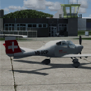
Dieses kleine Flugfeld liegt ca. 21 km nordöstlich von Mistelbach und ca. 14,5 km östlich von Poysdorf.
Breclav ist ca. 10,5 km nord-nordöstlich. Er wird von der "Flugsportgruppe Weinviertel" www.loar.at betrieben.
This airfield is transfered, with kind permission from Mr. Gerhard Scholz, from his x-plane Version with ADE.
have a look on his homepage http://www.x-plane.at.
|
| Filename: |
loar.zip |
| License: |
Freeware |
| Added: |
4th October 2017, 17:51:24 |
| Downloads: |
361 |
| Author: |
Karl Malle |
| Size: |
1500kb |
|
|
Images related to this file:
|
File Description:
Close to the mountain Aninger we find a small but nice airfield, mostly used by VFR pilots from the closed City of Vienna.
We have also a Flight school including helicopter training on this Airfield.
This airfield is transfered, with kind permission from Mr. Gerhard Scholz, from his x-plane Version with ADE.
have a look on his homepage http://www.x-plane.at.
|
| Filename: |
loav.zip |
| License: |
Freeware |
| Added: |
4th October 2017, 17:51:09 |
| Downloads: |
760 |
| Author: |
Karl Malle |
| Size: |
17062kb |
|
|
|
Images related to this file:
|
File Description:
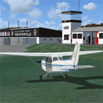
The sport flyer club Fürstenfeld operates this unique facility in the heart of the
"southeast Steirisch-Burgenland's Thermal Region, with over 180 members in the
sections of powered flight, gliding, parachuting and flying model.
This airfield is transfered, with kind permission from Mr. Gerhard Scholz, from his x-plane Version with ADE.
have a look on his homepage http://www.x-plane.at.
|
| Filename: |
logf.zip |
| License: |
Freeware |
| Added: |
4th October 2017, 03:31:03 |
| Downloads: |
536 |
| Author: |
Karl Malle |
| Size: |
15187kb |
|
|
Images related to this file:
|
File Description:
The airfield Trieben (LOGI) is certainly one of the best starting points for distance
flights in the Eastern Alps. Above all, the haul flights always made with more than 12
hours flight time and many flights over 1000km.
This airfield is transfered, with kind permission from Mr. Gerhard Scholz, from his x-plane Version with ADE.
have a look on his homepage http://www.x-plane.at.
|
| Filename: |
logi.zip |
| License: |
Freeware |
| Added: |
4th October 2017, 03:30:45 |
| Downloads: |
440 |
| Author: |
Karl Malle |
| Size: |
6007kb |
|
|
Images related to this file:
|
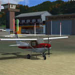
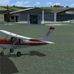
File Description:
The airfield Kapfenberg is 26 NM north of the airport Graz Thalerhof and 2 NM east
of Kapfenberg and is a popular approach destination in the sport aviation
I transferred this FSX Version from my x-plane Version with ADE.
|
| Filename: |
logk.zip |
| License: |
Freeware |
| Added: |
13th September 2017, 17:22:59 |
| Downloads: |
450 |
| Author: |
Karl Malle |
| Size: |
2092kb |
|
|
|
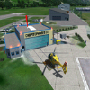
File Description:
The Civil Aerodrome LOGO is located in Niederöblarn, about 30 kilometers
east of Schladming, Styria. Since 2001, there is also a heliport located on the site of the airport (ICAO code:
LOGC). It is base to the crew of the Christophorus 14 rescue helicopter which is now fully functional.
This airfield is transfered, with kind permission from Mr. Gerhard Scholz, from his x-plane Version with ADE.
have a look on his homepage http://www.x-plane.at. Thank you to Manuel Bartl for his restless Beta Testing the new Version.
This scenery is compatible with "Austria Professional HD"
|
| Filename: |
logo14.zip |
| License: |
Freeware |
| Added: |
15th November 2017, 14:29:56 |
| Downloads: |
760 |
| Author: |
Karl Malle |
| Size: |
17789kb |
|
|
Images related to this file:
|
File Description:
The Civil Aerodrome LOGO is located in Niederöblarn, about 30 kilometers
east of Schladming, Styria. Since 2001, there is also a heliport located on the site of the airport (ICAO code:
LOGC). It is base to the crew of the Christophorus 14 rescue helicopter.
This airfield is transfered, with kind permission from Mr. Gerhard Scholz, from his x-plane Version with ADE.
have a look on his homepage http://www.x-plane.at.
|
| Filename: |
logo.zip |
| License: |
Freeware |
| Added: |
4th October 2017, 03:30:27 |
| Downloads: |
225 |
| Author: |
Karl Malle |
| Size: |
16779kb |
|
|
Images related to this file:
|
File Description:
The Airfield LOGP is located close to the styrian border in the direction of the Pinka river and North of the city of Pinkafeld.
I transferred this FSX Version from my x-plane Version with ADE.
|
| Filename: |
logp.zip |
| License: |
Freeware |
| Added: |
13th September 2017, 01:40:04 |
| Downloads: |
392 |
| Author: |
Karl Malle |
| Size: |
1998kb |
|
|
Images related to this file:
|
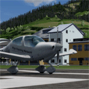
File Description:
LOIJ has a beautyfull location within the valley of St. Johann, surrounded by the mountain
“Wilder Kaiser”, “Kitzbühler Horn” and the “Lofener Steinbergen”. Located close to the bavarian Highlands,
and there fore easy to reach for pilots
I transferred this FSX Version from my x-plane Version with ADE.
|
| Filename: |
loij.zip |
| License: |
Freeware |
| Added: |
15th October 2017, 04:22:11 |
| Downloads: |
598 |
| Author: |
Karl Malle |
| Size: |
2199kb |
|
|
Images related to this file:
|
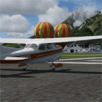
File Description:
The establishment of the SVA on 21 November 1953 was the launch of extensive
construction activity. In 1955, the members have created the conditions for approval
as a glider landing area by expending more than 7,000 volunteer hours. The
inauguration of the airfield took place on 17 June 1956th.
This airfield is transfered, with kind permission from Mr. Gerhard Scholz, from his x-plane Version with ADE.
have a look on his homepage http://www.x-plane.at.
|
| Filename: |
loir.zip |
| License: |
Freeware |
| Added: |
15th October 2017, 04:22:09 |
| Downloads: |
505 |
| Author: |
Karl Malle |
| Size: |
8204kb |
|
  |


