|
AVSIM Library - Search Results
|
|
Login | Register | About logging in and out
|
|
Searching for: 'gottfried razek' in AVSIM File Library and below.
|

|
|
|
|
|
|
File Description:
This is the first part of high resolution ground scenery for Tucson AZ, containing Tucson Intl. airport (KTUS) and 90 sq km around it. The resolution of the airport area itself is 0.3m/pix! The area around is in 1m/pix resolution. Realistic real-world runway textures are provided as well. This scenery is best, when combined with my standard resolution Tucson scenery (TUS2008_LR.zip), which covers a much larger area and matches perfectly in color and everything. YourDonation@Work: Dedicated to Robert, George and Jeff. Thanks!
| Filename: |
tus2008_hr.zip |
| License: |
Freeware, limited distribution |
| Added: |
10th September 2008, 23:58:16 |
| Downloads: |
4222 |
| Author: |
Gottfried Razek - www.blueskyscenery.com |
| Size: |
99517kb |
|
|
Images related to this file:
|
File Description:
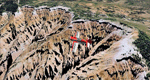
Cedar Breaks National Monument is a large amphitheater cliff in bright colors of red, orange and purple.
It lies east of Cedar City in the northern region of the scenery. The cliff was formed by erosion thru wind,
water and ice. Today erosion continues with a pace of about 2 inches every 5 years. Although it is called
Cedar Breaks, there are no cedars growing there but juniper trees. For a scenic flight to Cedar Breaks
National Monument best depart from Cedar City Regional Airport (KCDC) and head east. The scenery extends
south to Zion National Park and covers a large part of Zion Canyon and the Kolob Canyons area.
Zion National Park is another place where erosion of the Colorado Plateau formed the most beautiful colorful
stone formations of unique and wonderful shapes. There are nine different layers of stone visible in the park.
Most of them consist of sandstone. But there is also limestone, gypsum, siltstone, shale, clay and mudstone.
The Virgin River cut a spectacular and famous canyon thru Zion Park that is as narrow as 20ft and up to 2000ft tall.
High resolution versions of this scenery for FS9 and FSX (much sharper, but larger and multiple downloads)
are available at www.blueskyscenery.com/CNY_South2West5.html . The screenies are taken from the high-res versions,
so expect this version to be slightly more blurry.
Thanks to Joop Mak for providing a custom AFCADs that correct airport layouts so that they align with the photo-textures!
They are available here: www.blueskyscenery.com/AFCADs.html . YourDonation@Work: Dedicated to Richard, P.J. and Felix.
|
| Filename: |
cny_south2west5_2010_lr.zip |
| License: |
Freeware, limited distribution |
| Added: |
14th March 2010, 00:30:28 |
| Downloads: |
1531 |
| Author: |
Gottfried Razek - blueskyscenery.com |
| Size: |
99465kb |
|
|
|
Images related to this file:
|
File Description:
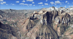
Covers the southern part of Zion National Park extends south along the cities of Hurricane and Colorado City. Zion National Park is another place where erosion of the Colorado Plateau formed the most beautiful colorful stone formations of unique and wonderful shapes. There are nine different layers of stone visible in the park. Most of them consist of sandstone. But there is also limestone, gypsum, siltstone, shale, clay and mudstone. The Virgin River cut a spectacular and famous canyon thru Zion Park that is as narrow as 20ft and up to 2000ft tall.
High resolution versions of this scenery for FS9 and FSX (much sharper, but larger and multiple downloads)
are available at www.blueskyscenery.com/CNY_South3West5.html . The screenies are taken from the high-res versions,
so expect this version to be slightly more blurry. Thanks to Joop Mak for providing custom AFCADs that
correct airport layouts so that they align with the photo-textures! They are available at www.blueskyscenery.com/AFCADs.html . YourDonation@Work: Dedicated to Jerry, Ralph J. and Lance.
|
| Filename: |
cny_south3west5_2010_lr.zip |
| License: |
Freeware, limited distribution |
| Added: |
20th March 2010, 23:26:42 |
| Downloads: |
1736 |
| Author: |
Gottfried Razek - blueskyscenery.com |
| Size: |
97681kb |
|
  |


