|
AVSIM Library - Search Results
|
|
Login | Register | About logging in and out
|
|
Searching for: 'gottfried razek' in AVSIM File Library and below.
|

|
|
|
|
|
|
File Description:
The original AFCAD of FS2004 doesn't match the photographic scenery of San Juan (TJSJ) by Gottfried Razek of Blue Sky Scenery. This is the replacing AFCAD.
| Filename: |
af2tjsj07_hr.zip |
| License: |
Freeware |
| Added: |
10th April 2007, 13:53:17 |
| Downloads: |
934 |
| Author: |
Joop Mak |
| Size: |
5kb |
|
|
File Description:
The original default AFCAD FS2004 files doesn't match the beautifull photografic scenery of Puerto Rico by Gottfried Razek from Blue Sky Scenery. Here are the replacing AFCADs.
| Filename: |
af2prtrc07_lr.zip |
| License: |
Freeware |
| Added: |
26th March 2007, 15:03:30 |
| Downloads: |
956 |
| Author: |
Joop Mak |
| Size: |
21kb |
|
|
|
File Description:
This scenery contains high resolution ground scenery for the airport of San Francisco Intl. (SFO). It makes me kind of nostalgic, because that's the area where I first successfully tried my hi-res mesh technique for FS2004. The scenery has a resolution of 1.2m/pix (4.7m/pix is FS2004-standard). Coverage is the area around SFO containing the San Bruno Mountain Park and the San Adreas Res. So it's quiet a sight! And don't forget to bring some flowers :-) The scenery gives best results when combined with with my "San Francisco" standard resolution ground scenery, which covers a much larger area at 4.7m/pix and matches perfectly in color and everything...
Won't work in FSX. For FSX please wait for the upcoming FSX-version of this scenery.
| Filename: |
sfo2006_hr.zip |
| License: |
Freeware, limited distribution |
| Added: |
27th November 2006, 10:58:19 |
| Downloads: |
16744 |
| Author: |
Gottfried Razek |
| Size: |
42803kb |
|
|
File Description:
This scenery is designed to work with Gottfried Razek's great Santa Barbara Municipal (KSBA) and Santa Ynez Mts, California Hi-Res Photo-Scenery. The default structures at KSBA and KIZA airports are replaced by custom 3d objects and runways/taxiways adjusted to conform to the accurate photo scenery. Razek's sba2008_hr_fsx.zip and sba2008_lr.zip freeware photo scenery is required.
| Filename: |
sbafsxph.zip |
| License: |
Freeware |
| Added: |
6th February 2009, 18:59:39 |
| Downloads: |
1093 |
| Author: |
Al Wheeler |
| Size: |
3845kb |
|
|
File Description:
This package contains high resolution ground scenery for the traffic pattern area of Santa Monica (SMO). Normal flight simulator scenery has a resolution of approximately 4.7 meters/pixel. That's OK at higher altitudes but leads to very blurry ground textures when flying low - e.g. in the traffic pattern. My high resolution airport area sceneries have a resolution 1.2 meters/pixel. This results in much more detail and a more realistic experience of "being there".
This scenery gives best results when combined with my "Southern-" and "Northern Los Angeles" standard resolution ground sceneries, available here:
Southern Los Angeles: http://library.avsim.net/esearch.php?CatID=fs2004scen&DLID=89921
Northern Los Angeles: http://library.avsim.net/esearch.php?CatID=fs2004scen&DLID=89911
For more information please visit: http://n330dg.batcave.net
| Filename: |
smo2006_hr.zip |
| License: |
Freeware, limited distribution |
| Added: |
23rd August 2006, 22:08:43 |
| Downloads: |
7951 |
| Author: |
Gottfried Razek |
| Size: |
18396kb |
|
|
File Description:
This is the sixt part of BlueSky's Sierra Nevada project and the second part of Seqouia National Park. Connects seamlessly and extends the first part (Sequoia I) to the west. Completes the High Sierra packages and brings the total to 21.000 sq km covering three National Parks (Sequoia, Kings Canyon and Yosemite). Works equally well in FS2004 and FSX. YourDonation@Work: Dedicated to the donators Markus, Michael and Bernd. Thanks!
| Filename: |
seq_west2008_lr.zip |
| License: |
Freeware, limited distribution |
| Added: |
3rd March 2008, 10:48:19 |
| Downloads: |
3933 |
| Author: |
Gottfried Razek (www.blueskyscenery.com) |
| Size: |
93105kb |
|
|
File Description:
This scenery contains ground scenery for the area of southern Los Angeles, LAX, TOA, HHR, LGB in standard FS-resolution of 4.7m/pixel.
| Filename: |
lax_south2005_lr.zip |
| License: |
Shareware, honor system |
| Added: |
17th August 2006, 04:05:49 |
| Downloads: |
17273 |
| Author: |
Gottfried Razek |
| Size: |
22394kb |
|
|
Images related to this file:
|
File Description:
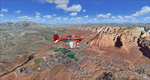
Covers the area between St. George, Utah and Mesquite, Nevada. To the north of St. George
the Pine Valley Mountains with their foothills of scenic red sandstone loom over the city.
St. George Municipal Airport (KSGU) is mostly used for general aviation but is also served by SkyWest Airlines
on behalf of Delta Connection. Because of it's location on a mesa this airport can't be expanded and so a new
airport is currently being built southeast of the city at the site of an abandoned airfield. The opening
is expected in 2011. To the south of the city make sure, you don't miss the Virgin River Gorge where the
Virgin River winds thru a long winding canyon in the transition zone between the red rocks of southern Utahs
Colorado Plateau and Nevadas Mojave Desert. Shortly afterwards you reach Mesquite which is situated just
west of the Arizona stateline. Like nearly all Nevada cities near the stateline Mesquite is home to several
Casinos. Mesquite Airport (67L) lies just north of the city.
High resolution versions of this scenery for FS9 and FSX (much sharper, but larger and multiple downloads)
are available at www.blueskyscenery.com/CNY_South3West6.html . The screenies are taken from the high-res versions,
so expect this version to be slightly more blurry. Thanks to Joop Mak for providing custom AFCADs that
correct airport layouts so that they align with the photo-textures! They are available at www.blueskyscenery.com/AFCADs.html .
YourDonation@Work: Dedicated to Werner, Ralf-Peter and Nels.
|
| Filename: |
cny_south3west6_2010_lr.zip |
| License: |
Freeware, limited distribution |
| Added: |
24th March 2010, 19:41:43 |
| Downloads: |
1615 |
| Author: |
Gottfried Razek - blueskyscenery.com |
| Size: |
97874kb |
|
|
Images related to this file:
|
File Description:
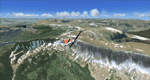
Steamboat Springs (KSBS), Flat Tops Wilderness Area, Colorado, Photo-Scenery (FS9 & FSX)
The Flat Tops Wilderness Area, which is the second largest wilderness area in Colorado, is named for its many flat topped mountains that are clearly visible from the sky. Trappers Lake, located in the north of the area inspired Arthur Carhart, a US Forest Service official, to initiate a plea for Wilderness preservation as early as 1919. Finally in 1975, three years before his death in 1978, the Flat Tops were designated a wilderness area. No wonder he found the area so entrancing: Behind Trappers Lake loom majestic volcanic cliffs, and beyond them a vast subalpine terrain reluctantly yields to alpine tundra with an average elevation of about 10.000 feet. More than 100 lakes dot the country above and below numerous flat-topped cliffs. Steamboat Springs is an internationally known winter resort destination.
To explore the scenery depart from Steamboat Springs Airport (KSBS) or Yampa Valley Airport (KHDN) and head south. High resolution versions of this scenery for FS9 and FSX (much sharper, but larger and multiple downloads) are available at www.blueskyscenery.com/GNB_West2.html . The screenies are taken from the high-res versions, so expect this version to be slightly more blurry. Thanks to Joop Mak for providing custom AFCADs that correct airport layouts so that they align with the photo-textures! They are available at www.blueskyscenery.com/AFCADs.html . YourDonation@Work: Dedicated to James.
|
| Filename: |
gnb_west2_2010_lr.zip |
| License: |
Freeware, limited distribution |
| Added: |
26th April 2010, 17:53:25 |
| Downloads: |
1276 |
| Author: |
Gottfried Razek - blueskyscenery.com |
| Size: |
93766kb |
|
|
Images related to this file:
|
File Description:
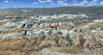
The southern part of this region covers the Box-Death Hollow Wilderness, with its vertical gray-orange walls of Navajo sandstone. Then comes the Aquarius Plateau which is the highest timbered plateau in North America with Boulder Mountain. In the north you'll find the little town of Torrey, which is just eight miles west of Capitol Reef National Park. Extends my Grand Staircase Escalante scenery to the north.
High resolution versions of this scenery for FS9 and FSX (much sharper, but larger and multiple downloads) are available at www.blueskyscenery.com/CNY_SouthWest3.html . The screenies are taken from the high-res versions, so expect this version to be slightly more blurry.
Thanks to Joop Mak for providing a custom AFCADs that correct airport layouts so that they align with the photo-textures! They are available here: www.blueskyscenery.com/AFCADs.html . YourDonation@Work: Dedicated to Ralf-Peter, Jon and Laurent.
|
| Filename: |
cny_southwest3_2010_lr.zip |
| License: |
Freeware, limited distribution |
| Added: |
3rd April 2010, 00:52:09 |
| Downloads: |
1179 |
| Author: |
Gottfried Razek - blueskyscenery.com |
| Size: |
96041kb |
|
  |


