|
AVSIM Library - Search Results
|
|
Login | Register | About logging in and out
|
|
Searching for: 'airstrips' in AVSIM File Library and below.
|

|
|
|
|
|
|
File Description:
This is the start of a project to have GA aircraft flying from all minor and obscure New Zealand airfields and grass strips. I have started with NZWT (Whitianga)NZTA (Te Aroha) NZME (Mercer) NZRA (Raglan) NZTH (Thames). I used charts from www.aip.net.nz to try and get accurate placements of aircraft parking etc. I also use these AFCADS in conjunction with the wonderful GA-Traffic program as it generates traffic automatically. I am in the process of creating flightplans which will be tabled later on. Soon we will have all the Waikato and other areas of NZ filled with GA traffic!! No more empty skies!!!
I have also uploaded NZWP (Whenuapai) with ammended airstrips, helipads etc. Some parking available but by no means finished. Feel free to change, alter or generally make more accurate these files and re-upload them for the benefit of all. Enjoy.
| Filename: |
af2_nz_airfields.zip |
| License: |
Shareware, honor system |
| Added: |
13th August 2004, 14:42:55 |
| Downloads: |
961 |
| Author: |
Doug Stone |
| Size: |
8kb |
|
|
Images related to this file:
|
File Description:
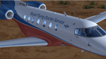
Royal Flying Doctors Services - VH-VSA. The Pilatus PC-24 long range jet is set to revolutionise aero medicine for the patients of the Royal Flying Doctor Service, ensuring better outcomes for people in WA. The RFDS will welcome the first of 3 new Pilatus PC-24 long range jet aircraft from 2017. The innovative aircraft will deliver increased fuel efficiency with twice the cruising speed of the PC-12. With an increased capacity to carry three stretchered patients, the ability to land on unpaved airstrips and shorter take off and landing capabilities, the PC-24 jets will be a game changer for the RFDS. Ultimately, it means we will be able to retrieve patients even more efficiently, and faster, from a greater number of locations around the state. Textures only. You need a legal copy of the IRIS PC-24.
|
| Filename: |
iris_pc-24_svj_vh-vsa.zip |
| License: |
Freeware |
| Added: |
29th April 2018, 16:25:35 |
| Downloads: |
915 |
| Author: |
Eberhard Haberkorn / IRIS Simulations |
| Size: |
44063kb |
|
|
|
File Description:
This is the second in the series of making GA aircraft populate small airfield around New Zealand. Improvements have been made to my first existing AFCAD files and now FSE files and flightplans are included for added realism! New airfields included are: NZCX (Coromandel) NZGB (Great Barrier) NZDA (Dargaville) NZUN (Pauanui Beach) Enjoy - as there's lots more to come yet!!!
| Filename: |
new_zealand_airstrips_and_airfields_2.zip |
| License: |
Freeware |
| Added: |
20th August 2004, 22:25:26 |
| Downloads: |
900 |
| Author: |
Doug Stone |
| Size: |
27kb |
|
|
File Description:
"Johnson Creek Airport (FAA LID: 3U2) is a grass airstrip located in Central Idaho three miles (5 km) south of Yellow Pine, a village in Valley County, Idaho, United States. It is managed by the Idaho Division of Aeronautics of the Idaho Transportation Department. A caretaker resides at the field, and as a result, the turf runway is well cared for. Johnson Creek is in the category of backcountry airstrips, and is popular with pilots who enjoy airplane camping." - Wikipedia
This FSX rendition includes volumetric grass, static aircraft, 1 meter/pixel photoscenery, 10 meter mesh, full autogen annotation, and is color corrected and blended into the surrounding scenery.
| Filename: |
3u2_johnson_creek_airport.zip |
| License: |
Freeware, limited distribution |
| Added: |
22nd July 2012, 20:11:57 |
| Downloads: |
879 |
| Author: |
Orion Lyau |
| Size: |
12994kb |
|
|
Images related to this file:

|
File Description:
California Central Coast Scenery for FSX with Megascenery Earth and FSGenesis mesh. CCFSXMSG.ZIP covers the California coastal region from N36° 10' (Coalinga) to N34° 25' (Santa Barbara) and from the coast East to W119° 40'. It is a version of my previously created California Central Coast scenery redesigned and expanded to work with FSX MegaScenery Earth and FSGenesis USA Terrain Mesh for FSX V2 by Justin Tyme. Airstrips in the area covered by this scenery have been added for a total of 27 airports and airstrips. 6 imaginary water runways are also added for AI float plane traffic. Several other areas of interest such as the Santa Barbara marina, Morro Bay, etc. are included for a total of 41 points of interest. All airports, airstrips and related structures have been adjusted and realigned to conform to actual positions and dimensions as indicated by the MegaScenery Earth satellite textures. Megascenery Earth California-13, -14 and -15 are required and -12, -28 and -29 are recommended. By Al Wheeler 9/25/09.
|
| Filename: |
ccfsxmsg.zip |
| License: |
Freeware |
| Added: |
7th January 2010, 19:54:57 |
| Downloads: |
867 |
| Author: |
Al Wheeler |
| Size: |
8325kb |
|
|
File Description:
This flightplan is for Sun Air Fiji for the summer of 05. This flightplan is compatible with the MRAI installer, but was not created by that orgaqnization. This flightplan uses repaints that are available here on AVSIM. This flightplan requires the Fiji Airstrips download by Adrian Wright to work. Also availale here on AVSIM.
| Filename: |
mrai_su05_sun_air.zip |
| License: |
Freeware |
| Added: |
1st April 2005, 00:38:29 |
| Downloads: |
845 |
| Author: |
Karl Hannestad |
| Size: |
5kb |
|
|
File Description:
Idaho Altisurfaces. Sloped airstrips (altisurfaces) of Mile Hi USFS, Soldier Bar USFS and Vines, Idaho USA.To be used with FSGenesis 38M Rocky Mountain mesh. Afcad2 files by Phil "Snowman" Cayton. Packaged and uploaded by Don Lively with permission of the designer.
| Filename: |
idahoaltisurfaces.zip |
| License: |
Freeware |
| Added: |
30th December 2005, 20:27:43 |
| Downloads: |
804 |
| Author: |
Guy Nemoz |
| Size: |
1380kb |
|
|
File Description:
P-61B BLACK WIDOW for x-plane 6.4/6.51
The need for a true night fighter aircraft was well demonstrated during the Battle of Britain in 1940. Aircraft used to counter German night attacks were not very effective. At the direction of the Air Corp's Carl A. Spaatz, John Northrop submitted a ground up night fighter design, which, designated as the XP-61, first flew on May 26, 1942. The Black Widow was the first aircraft designed from the ground up as a night fighter. Its innovative slotted flaps and spoiler ailerons allowed operation from short airstrips and improved handling; the radar carried in its nose made it the dominant force in the night skies of Europe and the South Pacific. From July 6, 1944, when it claimed its first victory, to war's end, the P-61 distinguished itself as one of America's most unique fighting machines. After the war, P-61s were used in reconnaissance, weather research, and flight testing. The first American flight ejections were made from a P-61.
Only four P-61 aircraft are known to exist today.
SPECIFICATIONS:
ENGINES: 2 Pratt and Whitney R-2800 2000 HP radials
WING SPAN: 66.0 ft.
LENGTH: 49.42 ft.
HEIGHT: 14.67 ft.
MAXIMUM SPEED: 366 MPH
ARMAMENT: Four 20mm Cannon.
| Filename: |
p61_black_widow_114085.zip |
| License: |
Freeware, limited distribution |
| Added: |
10th March 2003, 03:32:18 |
| Downloads: |
800 |
| Author: |
Robert App |
| Size: |
1414kb |
|
|
File Description:
West Australian Country Airstrips TOUR.
A Flight Plan and Flight for a tour of the Airstips supplied in the Brilliant and interesting West Australian Country Airsrips Scenery by Dennis Stiglmayer. Explore each Airstrip after landing - you will be pleasantly surprised at each one.
Caution there may be wildlife close to the runways!
Save your flight at any time to continue Later
| Filename: |
australian_country_airports_tour.zip |
| License: |
Freeware |
| Added: |
18th September 2005, 15:33:55 |
| Downloads: |
749 |
| Author: |
Alan Trussell |
| Size: |
28kb |
|
|
File Description:
Created missing AFCAD files for Canada Northwest Territories airstrips, so you can populate with AI traffic.
Great for De Havilland Beavers and Otters.
Requires AFCAD by Lee Swordy. If you have AFCAD's newer versions you can just drop in the AFCAD installer screen and you are done. Enjoy!
CYFS, Ft Simpson, Canada
CFJ2, Wekweti, Canada
CEV9, Snare River, Canada
CEV4, Rae Lakes, Canada
CET9, Jean Marie River, Canada
CET4, Island, Canada
CEM3, Wha Ti, Canada
CEL3, Lutsel K'e, Canada
| Filename: |
canadanwt1.zip |
| License: |
Freeware |
| Added: |
21st December 2002, 20:02:02 |
| Downloads: |
723 |
| Author: |
Alex Feldstein |
| Size: |
7kb |
|
  |


