|
AVSIM Library - Search Results
|
|
Login | Register | About logging in and out
|
|
Searching for: 'gottfried razek' in AVSIM File Library and below.
|

|
|
|
|
|
|
Images related to this file:
|
File Description:
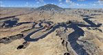
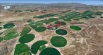
This package contains the center of Lake Powell and the Navajo Nation around Navajo Mountain. It contains remote areas of stunning beauty. Wonderful sandstone formations in bright shades of red and pink. Contains landmarks like the Rainbow Bridge National Monument and the confluence of the Colorado and San Juan Rivers. Extends my Monument Valley scenery to the west and brings you another 3.500 sq km in 4.7m/pix quality. To explore the scenery depart from Navajo Mountain dirt strip (04UT). High resolution versions of this scenery for FS9 and FSX (much sharper, but larger and multiple downloads) are available at www.blueskyscenery.com/CNY_South3West2.html . The screenies are taken from the high-res versions, so expect this version to be slightly more blurry. YourDonation@Work: Joaquin, Donald and Scott.
|
| Filename: |
cny_south3west2_2010_lr.zip |
| License: |
Freeware, limited distribution |
| Added: |
23rd January 2010, 23:06:49 |
| Downloads: |
1710 |
| Author: |
Gottfried Razek - blueskyscenery.com |
| Size: |
93629kb |
|
|
Images related to this file:

|
File Description:
This package contains photo-scenery for the greater area of Las Vegas, covering an area of 3.250 sq km and is dedicated to the donators Donald, John and David. The scenery reaches from the foothills of Mt. Charleston to Lake Mead (partly covered). The quality is in standard FS2004-resolution of 4.7m/pixel. It works equally well in FS2004 and FSX. Hi-Res overlays fill follow. For a complete list of available titles please visit us at www.blueskyscenery.com
|
| Filename: |
las2007_lr.zip |
| License: |
Freeware, limited distribution |
| Added: |
30th December 2009, 18:01:52 |
| Downloads: |
10779 |
| Author: |
Gottfried Razek - blueskyscenery.com |
| Size: |
82523kb |
|
|
|
Images related to this file:
|
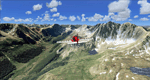
File Description:
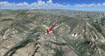
Extends my Aspen scenery to the east and contains more gorgeous Continental Divide area of the Rocky Mountains. Covers Leadville Lake County Airport (KLXV), which is the highest airport in North America (9.927 ft) and Mt. Elbert, which is the highest peak in the Rocky Mountains (14.443 ft). Aircraft performance deteriorates
with altitude, so many companies use the Leadville Airport as a base for high altitude performance testing. This scenery brings you another 3.500 sq km of beautiful Colorado in 4.7m/pix quality.
High resolution versions of this scenery for FS9 and FSX (much sharper, but larger and multiple downloads) are available at www.blueskyscenery.com/GNB_South2West.html . The screenies are taken from the high-res versions, so expect this version to be slightly more blurry. YourDonation@Work: Dedicated to Daniel, Art and Rotui.
|
| Filename: |
gnb_south2west_2010_lr.zip |
| License: |
Freeware |
| Added: |
1st February 2010, 19:06:58 |
| Downloads: |
1675 |
| Author: |
Gottfried Razek - blueskyscenery.com |
| Size: |
96957kb |
|
|
Images related to this file:
|
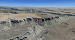
File Description:
Mesa Verde National Park is famed for its numerous ruins of cliff dwellings built in the 12th century by ancient Pueblo people called Anasazi. Cliff dwellings are highly defensible stone villages situated under alcoves (rock overhangs) along the canyon walls. The largest cliff dwelling in the park is Cliff Palace, which is the largest cliff dwelling in North America. Cliff Palace contained 150 rooms and housed approximately 100 people. Unfortunately you won't see the cliff dwellings from the air, because they are under the cliffs but you will see everything else like all roads, trails and facilities. Very little is known about the Anasazis and the reason for their sudden departure at the end of the 13th century remains a mystery. Theories range from crop failures due to droughts to an intrusion of foreign tribes from the North. The name "Mesa Verde" stems from Spanish explorers seeking for a route from Sante Fe to California. They named the region Mesa Verde (spanish for green table) because of its high, tree-covered plateaus. High resolution versions of this scenery for FS9 and FSX (much sharper, but larger and multiple downloads)
are available at www.blueskyscenery.com/GNB_West2.html . The screenies are taken from the high-res versions, so expect this version to be slightly more blurry. Thanks to Joop Mak for providing custom AFCADs that correct airport layouts so that they align with the photo-textures! They are available at www.blueskyscenery.com/AFCADs.html . YourDonation@Work: Dedicated to David.
|
| Filename: |
tex_southwest_2010_lr.zip |
| License: |
Freeware, limited distribution |
| Added: |
1st May 2010, 03:55:31 |
| Downloads: |
1441 |
| Author: |
Gottfried Razek - blueskyscenery.com |
| Size: |
95095kb |
|
|
Images related to this file:
File Description:
Monument Valley is an impressive sight in south Utah but not, unfortunately, in FS9. Unless you invest in a detailed terrain mesh there are no stacks of rocks reaching for the sky and the lasting overall impression is just of a desert. But I had already downloaded the land textures so I ended up making the Monument Valley UT25 airfield and the nearby Oljato 05UT, which has no buildings of any sort. Maybe I was bored. There is a lodge close to the field with dozens of cabins, but I had insufficient information so this is for the airfield only. The 4,000 feet of new tarmac is aligned 16-34 and is single ended with a large chunk of rock at the southern end; 16 is only used for landing and 34 is only for take off. The runway is not lit. Do not be surprised when you ask to select a runway for take off and FS9 only gives you 16 as a choice, even though you know this is the wrong one. When you accept it FS9 will quickly switch it to 34; apart from a possible sense of humour I have no idea why it does this. Nothing much to say about Oljato. What do you need? You actually don't need Ultimate Terrain as there are other land textures used here, so you will definitely need to have downloaded and installed the land textures "cny_south3west_2010 lr" and "cny_south3west2_2010 lr" by Gottfried Razek, as these land textures showed the runways in the correct positions. Look in the scenery library here or at the other place. A note here about my scenery making. There will not be many more to follow this (unless you count 4 as many) as I am almost at the end of the photos I either took or found for scenery purposes, plus I expect to move on from FS9 at some point during next year.
| Filename: |
monument_valley.zip |
| License: |
Freeware, limited distribution |
| Added: |
22nd January 2020, 20:13:54 |
| Downloads: |
183 |
| Author: |
Roger Wensley |
| Size: |
2996kb |
|
|
Images related to this file:
|
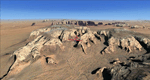
File Description:
Monument Valley, Kayenta (0V7), Utah/Arizona, Photo-Scenery (FS9 & FSX)
This scenery covers the area from south of the San Juan River down to wonderful Monument Valley and Kayenta, AZ.
It extends my Lake Powell sceneries to the south and brings you another
3.500 sq km in 4.7m/pix quality. To explore the scenery depart from Kayenta (0V7) and head north.
High resolution versions of this scenery for FS9 and FSX (much sharper, but larger and multiple downloads) are available at www.blueskyscenery.com/CNY_South3West.html . The screenies are taken from the high-res versions, so expect this version to be slightly more blurry. YourDonation@Work: Dedicated to Thomas, Don and Eric.
|
| Filename: |
cny_south3west_2010_lr.zip |
| License: |
Freeware, limited distribution |
| Added: |
23rd January 2010, 10:45:32 |
| Downloads: |
2237 |
| Author: |
Gottfried Razek - blueskyscenery.com |
| Size: |
95734kb |
|
|
Images related to this file:
|
File Description:
Mormon Range, Enterprise, Beryl (UT82), Utah, Photo-Scenery (FS9 & FSX)
This scenery covers the area of just north of St. George (KSGU) north along the Mormon Range and Enterprise to Beryl (UT82). It completes the southwestern corner of Utah and paves our way into Nevada. High resolution versions of this scenery for FS9 and FSX (much sharper, but larger and multiple downloads)are available at www.blueskyscenery.com/CNY_South2West6.html . The screenies are taken from the high-res versions, so expect this version to be slightly more blurry.
Thanks to Joop Mak for providing a custom AFCADs that correct airport layouts so that they align with the photo-textures! They are available at www.blueskyscenery.com/AFCADs.html . YourDonation@Work: Dedicated to Jean Pierre, Konrad and Juan.
|
| Filename: |
cny_south2west6_2010_lr.zip |
| License: |
Freeware, limited distribution |
| Added: |
27th March 2010, 11:38:48 |
| Downloads: |
1343 |
| Author: |
Gottfried Razek, blueskyscenery.com |
| Size: |
99792kb |
|
|
File Description:
This scenery contains ground scenery for the area of central and northern Los Angeles, SMO, BUR and VNY in standard FS-resolution of 4.7m/pixel.
| Filename: |
lax_north2005_lr.zip |
| License: |
Shareware, honor system |
| Added: |
17th August 2006, 03:52:59 |
| Downloads: |
17008 |
| Author: |
Gottfried Razek |
| Size: |
40549kb |
|
|
Images related to this file:
|
File Description:
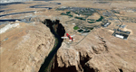
This scenery covers the western part of Lake Powell, the city of Page (KPGA), the Vermillion Cliffs, Glenn Canyon just south of Glenn Canyon Dam, the northern part of Marble Canyon, Paria Canyon, Cockscomb, etc, etc. Spectacular! To explore the scenery depart from Page Municipal Airport (KPGA). High resolution versions of this scenery for FS9 and FSX (much sharper, but larger and multiple downloads) are available at www.blueskyscenery.com/CNY_South3West3.html . The screenies are taken from the high-res versions, so expect this version to be slightly more blurry. YourDonation@Work: Dedicated to William, Veit and Michele.
|
| Filename: |
cny_south3west3_2010_lr.zip |
| License: |
Freeware, limited distribution |
| Added: |
3rd March 2010, 21:26:32 |
| Downloads: |
1757 |
| Author: |
Gottfried Razek - blueskyscenery.com |
| Size: |
94625kb |
|
|
Images related to this file:
|
File Description:
Covers the gap between my Leadville and Colorado Springs North sceneries and provides you with continuous coverage for longer cross country flights. High resolution versions of this scenery for FS9 and FSX (much sharper, but larger and multiple downloads) are available at www.blueskyscenery.com/GNB_South2.html . The screenies are taken from the high-res versions, so expect this version to be slightly more blurry. YourDonation@Work: Dedicated to Arthur and Pierre-Alain.
|
| Filename: |
gnb_south2_2010_lr.zip |
| License: |
Freeware, limited distribution |
| Added: |
3rd February 2010, 22:19:58 |
| Downloads: |
1391 |
| Author: |
Gottfried Razek - blueskyscenery.com |
| Size: |
91636kb |
|
  |


