|
AVSIM Library - Search Results
|
|
Login | Register | About logging in and out
|
|
Searching for: 'asphalt textures' in AVSIM File Library and below.
|

|
|
|
|
|
|
Images related to this file:
|
File Description:
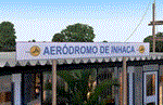
A Gmax representation of Inhaca Airport (FQIA), Inhaca Island, Mozambique with photoreal textures.
Inhaca island is a small island situated about 32 km east of Maputo, the capital of Mozambique. Transairways provide daily flights from Maputo airport to Inhaca airport, typically with smaller (18 seat) aircraft and the flight lasts no more than about 15 minutes.
The airport consist of a very small terminal building and two runways. Runway 18/36 (asphalt) measuring 650m and runway 10/28 (grass) which also measures 650m.
|
| Filename: |
worx57.zip |
| License: |
Freeware, limited distribution |
| Added: |
12th September 2015, 00:12:07 |
| Downloads: |
341 |
| Author: |
Kobus van Wyk, Aeroworx |
| Size: |
1289kb |
|
|
Images related to this file:
|
File Description:
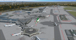
This is a major update to the previous airport package (Frankfurt ILS25R V2.2 package) using ADE 1.47 and represents the layout of the airport in June 2010.
Features now include updated ILS/DME capabilities to runways as per recent changes, a completely revised South City Cargo area, updated aprons including new flood lit lighting and a new Lufthansa A380 hangar built in Gmax.
Revised airline gate allocations for Terminal 1 and Terminal 2 included plus the addition of 5 new A380 gates at Terminal 2. A new control tower on the north parking apron has been added in preparation for the A-plus terminal expansion.
Runways and several taxiway textures changed to asphalt as per resurfacing work at real airport.
Improved quality CAT II/III signage available at intersections and new No Entry signage added for specific taxiways for extra realism.
Many other features from the previous packages are still included. See readme file for detailed information
|
| Filename: |
frankfurt_airport_v3.zip |
| License: |
Freeware |
| Added: |
25th October 2010, 10:30:49 |
| Downloads: |
3680 |
| Author: |
Mark Aldridge |
| Size: |
3043kb |
|
|
|
Images related to this file:
|
File Description:
Graskop Airfield does not appear in the default FS2004, neither is the town included which is a pity as the airfield lies right on the edge of a gorge where bungee jumping and even a Gorge-lift (elevator) or a slide across the gorge can be enjoyed by the adrenaline junkies. Added to this, the airfield (and town of Graskop) is merely 10km from the world famous God's Window (also featured in the film, "The Gods must be Crazy").
This package will add a custom (Gmax & Sketchup) made Graskop Airfield, Mpumalanga, South Africa with photoreal textures and ground textures. The included Landclass file will also add the town.
The small airfield has been recreated with custom true to life models and photoreal textures. While being a very small airfield with only one hangar and a large antenna tower, the importance of the airfield far outweighs its size. The airfield plays a vital role in the fight against wildfires as there are water bombers based at the airfield during critical times. In real life the runway is quite challenging, being sloped quite significantly and very narrow, with a one-way-in one-way-out landing and takeoff procedure. Due to the limits within flightsim, the slope could not be replicated but all the other challenges are there.
The asphalt runway is aligned 15/33 and only 800m long by 8.5m wide and sits at an elevation of 4 854ft.
|
| Filename: |
buscen06.zip |
| License: |
Freeware, limited distribution |
| Added: |
3rd September 2021, 00:55:30 |
| Downloads: |
130 |
| Author: |
Kobus van Wyk & Morne van Wyk |
| Size: |
4238kb |
|
|
File Description:
Located 01 miles E of West Milford, New Jersey on 150 acres of land, Greenwood Lake Airport is a public asphalt strip that services small to medium GA air traffic. The second runway that used to be there has been re-paved and now serves as extra aircraft parking. You can park anywhere on the closed runway, along the edge of the main tarmac where the terminal building is, or between any two white cones (50 foot max wingspan) that mark tie-down locations in the middle of the main tarmac. A helicopter start is provided as well. For parking, Small GA spaces are for craft with wingspans of less than 50 feet; Medium GA spaces are for craft with wingspans from 50-60 feet. The glide slope for Runway 24 has been adjusted up from 3.5 degrees to 4 degrees as in real life the runway sits higher than the ground the trees grow from so this will give you proper clearance on approach. Fuel is available by stopping near the tank on the main tarmac. Scenery constructed with use of satellite images/streetview/aerial photos - the author has not been there in person. This scenery is meant to be used in conjunction with MegaScenery Earth New York 005. It is not required, but apron use is minimized to allow satellite scenery to show through as much as possible, and objects are placed based on the MSE textures - lack of it may make scenery look out of place.
| Filename: |
4n1.zip |
| License: |
Freeware |
| Added: |
22nd July 2011, 03:59:26 |
| Downloads: |
476 |
| Author: |
Drew Sikora |
| Size: |
2020kb |
|
|
File Description:
Located 03 miles SW of Hackettstown, New Jersey on 65 acres of land, Hackettstown Airport is a public asphalt strip 2200' in length. Fuel, tiedowns and hangars are all available for transient aircraft. For fuel, stop on the concrete pad next to the fuel tank northeast of the runway - 100LL only. Tiedowns are available both east and west of the runway - note that west parking faces the trees and if you start in one of the West Parking spots you will either need to pushback or slew to give yourself room to turn out - static aircraft collisions are off but vegetation is not. The one hangar north of the airport is open for parking, you can start there with the DOCK type parking location. This airport is not lit so daytime VFR operations only are recommended.
Scenery constructed with use of satellite images/streetview/aerial photos - the author has not been there in person.
This scenery is meant to be used in conjunction with MegaScenery Earth New York 007. It is not required, but apron use is minimized to allow satellite scenery to show through as much as possible, and objects are placed based on the MSE textures - lack of it may make scenery look out of place.
| Filename: |
n05.zip |
| License: |
Freeware |
| Added: |
13th May 2011, 09:16:30 |
| Downloads: |
207 |
| Author: |
Drew Sikora |
| Size: |
555kb |
|
|
File Description:
Located 03 miles NE of Hammonton, New Jersey on 107 acres of land, Hammonton Municipal Airport is a public asphalt strip 3601' in length. It has recently been renovated with all-new taxiways and aprons and this update is depicted in this version with the big change being the extension of the main apron to join the previously-separated north and south tarmacs. The airport's magnetic variation, traffic pattern height, and PAPI glide slope and location have also all been accurately adjusted. All tie down parking locations are located on either the North or South tarmacs. Parking spots marked as RAMP_GA are occupied by static aircraft/objects and should not be chosen to start in (although all static objects have collision disabled). North parking spots can accommodate wingspans up to 50' while South parking spots should only be used by aircraft with wingspans of 40' or less. The one DOCK_GA location in the hangar start that can accommodate aircraft with wingspans up to 45'. The helicopter start location will place you on the North tarmac in front of the main hangar. Fuel is available by stopping on the concrete area on the North tarmac or by the fuel truck on the South tarmac in front of the hangars. Please see the ReadMe for known issues regarding AI aircraft parking.
Scenery constructed with use of satellite images/streetview/aerial photos - the author has not been there in person.
This scenery is meant to be used in conjunction with MegaScenery Earth New Jersey/Delaware 003. It is not required, but apron use is minimized to allow satellite scenery to show through as much as possible, and objects are placed based on the MSE textures - lack of it may make scenery look out of place.
| Filename: |
n81.zip |
| License: |
Freeware |
| Added: |
5th June 2011, 06:22:53 |
| Downloads: |
202 |
| Author: |
Drew Sikora |
| Size: |
892kb |
|
|
Images related to this file:
|
File Description:
FS2004 Scenery for Inyokern Airport (KIYK). SORRY everyone there were some libraries and textures missing from the recent release. This package contains all missing objects and libraries and is a complete replacement for ANY of my Inyokern sceneries previously installed, no other download required. (Nestled on the sunny side of the southern Sierras, Inyokern is a great jumping-off place for hi desert adventures. Known for decades for it's great soaring spots, Inyokern itself is busy enough with an average of 80 flights a day including it's United/Skywest commuter flights and occasional military traffic from the nearby China Lake Naval Weapons Test Center. Geographically, the airport is situated in the high desert of Southern California, 100 miles east-northeast of the county seat in Bakersfield, 80 miles north-northeast of the Lancaster and Palmdale areas, and 120 miles north-northwest of San Bernardino. The airport itself covers 1,640 acres at an elevation of 2,457 feet, with three asphalt paved runways that can accommodate almost any class of civilian, commercial, or military aircraft. Inyokern Airport is served by commercial airlines connecting through Los Angeles International Airport.)
|
| Filename: |
kiyk3_js.zip |
| License: |
Freeware, limited distribution |
| Added: |
10th November 2013, 23:32:02 |
| Downloads: |
2013 |
| Author: |
John Stinstrom |
| Size: |
6510kb |
|
|
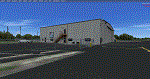
Images related to this file:
File Description:
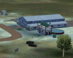
KCEY is a public use, single runway airport located 4 miles NW of Murray KY. Runway 5/23 is an asphalt runway 6203x100 feet long. 100LL, Jet-A and MOGAS are available at this airport.
I added an area of photo real about a mile square around the airport. It blends best with Orbx Global and LC North America. All the airport objects such as hangers, fences, fuel tanks, signs, etc. are all custom made objects based on pictures obtained on-site. The runways, taxiways and aprons are all custom textures as well as runway and taxiway lights. This is an authentic recreation of the real world airport.
| Filename: |
kcey.zip |
| License: |
Freeware |
| Added: |
12th March 2018, 22:15:59 |
| Downloads: |
200 |
| Author: |
Shannan G Landreth |
| Size: |
67758kb |
|
|
Images related to this file:
|
File Description:
KJQD is a public use, one runway airport located 3 miles NE of Hartford KY.
Runway 3/21 is an asphalt runway 5000x75 feet long. 100LL and Jet-A are available at this airport.
I added an area of photo real about a mile square around the airport. It blends best with Orbx Global and LC North America. All the airport objects such as hangers, fences, fuel tanks, signs, etc. are all custom made objects based on pictures obtained on-site. The runways, taxiways and aprons are all custom textures as well as runway and taxiway lights. This is an authentic recreation of the real world airport.
|
| Filename: |
kjqd.zip |
| License: |
Freeware |
| Added: |
22nd January 2018, 23:09:44 |
| Downloads: |
344 |
| Author: |
Shannan G Landreth |
| Size: |
47076kb |
|
|
Other files which are related to, or may be required by, this file:
File Description:
This is an update only for the "LFST - Strasbourg-Entzheim, France" scenery. Update features:
- More realistic asphalt textures
- Custom runway and taxiway signs
- Conversion of 6 dxt5 textures into dxt1
- Better integration of the photorealistic ground below the final of runway 23
- Objects shadows are now supported
- New control tower updated
- Many objects improved (for better fps)
- Some minor corrections
| Filename: |
lfst4fsx_upd1.zip |
| License: |
Freeware, limited distribution |
| Added: |
13th April 2014, 17:43:51 |
| Downloads: |
10728 |
| Author: |
Jacques-Paul Bollard |
| Size: |
9086kb |
|
  |


