
Where Flight Simulation Enthusiasts Gather from Around the World!
AVSIM Library - Search Results

| Category: Flight Simulator 2002 - Scenery | |
| Asphalt Runway Textures |

|
File Description:
This file will replace the default Fs2002 asphalt runway textures with some newer and more realistic looking ones!
| Filename: | asphaltrw.zip |
| License: | Freeware, limited distribution |
| Added: | 27th August 2002, 03:28:40 |
| Downloads: | 1,538 |
| Author: | Esteban Aldarondo |
| Size: | 133 KB |
| Category: Flight Simulator 2002 - Scenery | |
| Asphalt Runway Textures: Fix |
|
File Description:
This upload will now include the runway12.bmp that were missing on the previous upload "Asphalt Runway Textures." Sorry and thankyou for letting me know!!
| Filename: | asphaltrw_103277.zip |
| License: | Freeware, limited distribution |
| Added: | 28th August 2002, 03:01:06 |
| Downloads: | 1,739 |
| Author: | Esteban Aldarondo |
| Size: | 185 KB |
| Category: Flight Simulator 2004 - Scenery Design | |
| Asphalt Txtures |
|
File Description:
This package includes some textures to be used for making sceneries.
Made from real asphalt pictures (from a road, but still usefull).
| Filename: | textures_for_scenery_design.zip |
| License: | Freeware |
| Added: | 16th May 2004, 23:34:00 |
| Downloads: | 1,697 |
| Author: | Nils Lips |
| Size: | 74 KB |
| Category: Flight Simulator 2004 - Scenery Design | |
| Asphalt Texture |
|
File Description:
Realistic asphalt textures, for all airports.
| Filename: | taxi_asphalt_texture_fshispanic.zip |
| License: | Freeware |
| Added: | 17th November 2004, 01:12:43 |
| Downloads: | 6,580 |
| Author: | Paulo Mauricio |
| Size: | 36 KB |
| Category: Flight Simulator 2004 - Scenery | |
| Asphalt Runway Texture |
|
File Description:
New asphalt and taxi textures.
| Filename: | asphalt_runway.zip |
| License: | Freeware |
| Added: | 4th June 2004, 22:28:59 |
| Downloads: | 4,674 |
| Author: | Arno Aksu |
| Size: | 291 KB |
| Category: Flight Simulator 2002 - Scenery | |
| New Asphalt Runway Textures (Darker than the default ones) |
|
File Description:
I've created a new darker texture for the asphalt runways. I got sick of the default one being unrealistic so I made a more realistic darker one, which is nearer to the colour of the real runway. I hope you guys enjoy it.
| Filename: | New_Asphalt_Runway_Textures_Darker_than_the_defaul.zip |
| License: | Freeware |
| Added: | 8th December 2002, 02:53:33 |
| Downloads: | 1,424 |
| Author: | Greg Russell |
| Size: | 57.99 KB |
| Category: Flight Simulator X - Scenery | |
| Revised Taxiway Textures |
|
File Description:
These are revised asphalt, concrete, and marking taxiway and ramp textures for FSX
| Filename: | Revised_Taxiway_Textures.zip |
| License: | Freeware |
| Added: | 7th May 2008, 08:29:29 |
| Downloads: | 3,399 |
| Author: | Al Wheeler and Miguel Zafra |
| Size: | 663.16 KB |
| Category: Flight Simulator X - Aircraft Repaints, Textures and Modifications | |
| Petra Airlines Airbus A320 |
|
File Description:
Petra Airlines repaint for the payware Blackbox A320. You must have the payware BBS A320.
| Filename: | textures.320_cfm_petra.zip |
| License: | Freeware |
| Added: | 18th August 2013, 09:30:39 |
| Downloads: | 49 |
| Author: | Mohammad Youssef |
| Size: | 2.76 MB |
| Category: Civil Flight Simulators - Looking Glass Flight Unlimited 3 | |
| New Runway Textures for FU3 |
|
File Description:
These are asphalt and concrete runway textures for use in FU3, for package designers.
Thanks to Ansgar and Jon for ideas and prompting!
| Filename: | New_Runway_Textures_for_FU3.zip |
| License: | Freeware |
| Added: | 4th June 2003, 12:20:42 |
| Downloads: | 262 |
| Author: | Robert Driscoll |
| Size: | 784.25 KB |
| Category: Prepar3D V1-4 - Scenery | |
| KCIR, Cairo Regional Airport |
|
Images related to this file:
File Description:
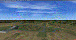
KCIR is a public use, two runway airport located 4 miles NW of Cairo, IL. Runway 14/32 is an asphalt runway 4001x100 feet long and Runway 2/20 is an asphalt runway 3200x60 feet long.
| Filename: | kcir.zip |
| License: | Freeware |
| Added: | 1st January 2018, 03:12:21 |
| Downloads: | 334 |
| Author: | Shannan Landreth |
| Size: | 43.74 MB |
© 2001-2025 AVSIM Online
All Rights Reserved