|
AVSIM Library - Search Results
|
|
Login | Register | About logging in and out
|
|
Searching for: 'ga-traffic' in AVSIM File Library and below.
|

|
|
|
|
|
|
Images related to this file:
File Description:
The town of Barrow is in the far north of Alaska, and these are coastal villages or radar installations to the west, south, and now east of Barrow. There will be further additions. Nuiqsut is a mainly Inuit community on the west side of the Colville River, around 20 miles south of the coast, and with a slowly declining population of around 420 or so. The airfield is just south of the town and has a gravel runway 5,000 feet long and aligned 04-22 in FS9. The airfield is the only year-round contact route to the rest of the world, though there are plans for a permanent road. The AI includes daily passenger flights early and late in the day, cargo deliveries, and some GA. It seems that the only photos I had of the airport were either of the old building or were not of Nuiqsut at all. The only pic I have seen (recently, which is why I now have doubts) of the new building is insufficient to model it, so I am sticking with the old or maybe incorrect version.
| Filename: |
alaska_north_slope_5.zip |
| License: |
Freeware, limited distribution |
| Added: |
21st June 2016, 21:45:32 |
| Downloads: |
235 |
| Author: |
Roger Wensley |
| Size: |
4661kb |
|
|
Images related to this file:
File Description:
The town of Barrow is in the far north of Alaska, and these are coastal villages or radar installations to the west of Barrow, and there will be additions. Cape Lisburne is a gravel runway right next to the coast with radar gear and accomodation buildings close by, and what was called "Top Camp" at the end of a long and steep road to the top of a nearby hill, or mountain. The runway is lit, as are most of them in this area of long dark winter nights. Barrow is 270 miles to the northeast. Point Lay PPIZ used to have a radar installation as well as a village, but the old buildings have now been removed and the gravel runway 05-23 has been lengthened to 5,000 feet to serve the village throughout the year. The population is around 270, living mostly traditionally and with an annual beluga whale hunt. Barrow is 180 miles to the northeast.
Wainwright PAWI, some 80 miles southwest of Barrow and on the coast, has a population of around 570. The PAWI runway is just under 5,000 feet long and like PPIZ is aligned 05-23, lit, and with PAPI on each end. The original runway of some 2,000 feet is still visible next to the apron. Three miles to the southeast there is a third runway, at AK03, serving the Wainwright DEW station. It was decided in 2007 to close the station and to remove the buildings both there and at Point Lay because of subsidence, but everything at Wainwright was still in place in 2009 and beyond. The villages have been "sketched" as opposed to replicated exactly. The texture folder includes the missing car textures for Barrow PABR, and the AI is modified PABR to include passenger flights by Ravn and cargo flights by Northern Air Cargo, plus limited GA. There are no flattened grassed areas at these airfields; they are runways and taxiways and aprons on a bed of gravel on permafrost.
| Filename: |
alaska_north_slope_2.zip |
| License: |
Freeware, limited distribution |
| Added: |
16th June 2016, 15:59:24 |
| Downloads: |
339 |
| Author: |
Roger Wensley |
| Size: |
11318kb |
|
|
|
Images related to this file:
File Description:
The town of Barrow is in the far north of Alaska, and is best known in flying circles as the place where Wiley Post crashed his floatplane on takeoff and killed himself and Will Rogers. The crash was some 15 miles south of Barrow and was "assisted" by the mismatched fuselage, wings, and floats that had been assembled to create the floatplane. The Barrow population is largely Inupiat and totals some 4,400. The downtown area of Barrow is immediately north of the airport. The second and largest part of Barrow is further north past a string of lagoons and is locally called Browerville. To the northeast along the coast is the smallest part around what used to be the Naval Arctic Research Lab, and is now a college. To the east of this are the DEW buildings, plus two large navy hangars and the gravel runway that was used to serve the DEW station. The PABR runway is aligned 06-24 in FS9 and is 7,100 feet long and 150 feet wide, built on top of a gravel base and surround that copes with the underlying permafrost. There is PAPI at both ends and an ILS and approach lights on 06; 06 circuits are to the right. The airport notes include a warning that the apron is not a standard width and that large planes that are enroute to the far end of the runway will not be able to taxi past a plane parked at the gate and should use the runway as a taxiway, then turn and takeoff. FS9 AI cannot cope with that, so the apron here is wider. There are, in real life and the AI, daily flights by Air Alaska (three at least) and Era (several, and which is now called Ravn, hence the new hangar door motif) and air cargo flights by Northern Air Cargo and Everts, plus GA. The buildings have been made with photographic textures or textures made from reference photos. I decided that while 500+ scenery objects was probably ok for most people the required 900+ to "make" the town of Barrow would likely not be. The auto-generated FS9 town objects could not be left as Barrow with trees would not look at all like reality; I have "faded" the density of the town buildings into the distance from the airport.
| Filename: |
barrow_alaska_v1.zip |
| License: |
Freeware, limited distribution |
| Added: |
17th May 2016, 09:32:36 |
| Downloads: |
918 |
| Author: |
Roger Wensley |
| Size: |
16134kb |
|
|
Images related to this file:
File Description:
The town of Kitchener is in southern Ontario, 40 miles southwest of Toronto. The population is just over half a million, including the adjoining Cambridge and Waterloo which are known locally as the Tri Cities. The Kitchener name was adopted in 1916, replacing the former "City of Berlin".
The airport is on the northeastern side of the town, with the main runway aligned 08-26 and just over 7,000 feet of asphalt 150 feet wide, lit, with PAPI at both ends and approach lighting and ILS on 26. The second runway is aligned 14-32 and is 4,100 feet long, lit and with PAPI at both ends; right hand circuits for 32. The airport is being steadily enlarged and improved, with new hangars for rental, operators, and maintenance companies. The largest and most visible presence is the training operation located just off the southwest end of taxiway A, where there are 14 Cessna 172, 2 Cessna 152, 2 Piper Seminole, and others. These are represented in the AI. There are morning and evening scheduled flights by Westjet to Calgary and American Eagle to Chicago, also in the AI. To the southwest, past taxiway C, there is GA parking; request taxi to what is named here "southwest parking" where there are spaces on both grass and asphalt. To the southeast, along a taxiway off the southeast corner of the main apron, are mainly operators and maintenance facilities. This version of CYKF includes the new(ish) terminal, the first of the new central rental hangars alongside the new taxiway and access road, and the very new large hangar off taxiway C, but not the new airport services building (fire and snow clearance) that is off to the southeast of taxiway A, and not the new car park to the south of the airport access road. So an uncertain and possibly historically innacurate date, but with the correct taxiway lighting and signage, and building textures from photographs.
| Filename: |
kitchener_waterloo.zip |
| License: |
Freeware, limited distribution |
| Added: |
7th May 2016, 21:13:28 |
| Downloads: |
521 |
| Author: |
Roger Wensley |
| Size: |
30902kb |
|
|
Other files which are related to, or may be required by, this file:
Images related to this file:
|
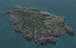
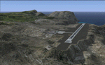
File Description:
This project is a port of my FSX release of the the new airport (FHSH) on St. Helena Island. This scenery provides more accurate coastlines and roads, as well as corrected landclass based on the latest available satellite imagery. Flight plans are provided for the proposed commercial service to St. Helena, and some additional GA and military flights to the island are added as well.
The FS2004 St. Helena (FHSH) airport was created by aligning master plans for the airport with current satellite data and by studying many of the pictures that have been posted as the airport has taken shape. The official opening of the real airport on May 21, 2016, has been pushed back for more field tests due to challenging crosswinds. Updates were created or rebuilt in a manner which carefully aligns airport data with current satellite imagery. Scenery was created using Airport Design Editor 9 v1.67.5684 and SBuilder. Scenery objects were added and modified from stock FS9 scenery to resemble as closely as possible the actual airports.
|
| Filename: |
fs9_st_helena_island.zip |
| License: |
Freeware |
| Added: |
5th May 2016, 07:44:38 |
| Downloads: |
2133 |
| Author: |
Carlyle Sharpe |
| Size: |
1637kb |
|
|
Other files which are related to, or may be required by, this file:
Images related to this file:
|
File Description:
This project was begun to add the new airport (FHSH) to St. Helena Island and eventually was expanded to include a complete remake of Ascension Island (FHAW) and Tristan da Cunha (with an optional airport FHTC) and Gough Island with the actual weather station heliport (FHGH). Tested in both the default FSX/Acceleration and with FTX Global/Vector, accurate coastlines, lakes, road data, and SRTMGL1 (30m) mesh, as well as corrected landclass are provided based on the latest available satellite imagery. Flight plans are provided for the proposed commercial service to St. Helena, and some additional GA and military flights to the island are added as well.
The FSX St. Helena (FHSH) airport was created by aligning master plans for the airport with current satellite data and by studying many of the pictures that have been posted as the airport has taken shape. The official opening of the real airport on May 21, 2016, has been pushed back for more field tests due to challenging crosswinds. The Ascension Island (FHAW) airport was updated after I realized that Ascension could receive commercial service as a result of the new St. Helena airport. The entire airfield is redesigned to allow the volcanic terrain to display properly. The airbase, towns, BBC Atlantic relay station, and numerous satellite dishes, radomes, and wind turbines now appear in their real-world locations. Since I was already in the region, I added the Tristan da Cunha Islands (including Inaccessible, Nightingale and Gough Islands) and the Gough Island weather station maintained by the South African National Antarctic Programme. I also added an optional airport (and flight plans) to Tristan da Cunha (FHTC), which can be easily enabled/disabled. The FHTC airport is placed on the only part of the island that appears to be free of people or farmland, and the area is just long enough to accommodate a pared-down version of the St. Helena airport.
Updates were created or rebuilt in a manner which carefully aligns airport data with current satellite imagery. Scenery was created using Airport Design Editor X v1.67.5684, SBuilderX 3.13, and the FSX Object Placement Tool. Scenery objects were added and modified from stock FSX scenery to resemble as closely as possible the actual airports. The animated flag model is by Dietmar Loleit, the FSX apron lights included are from the set created by Jim Dhaenens, and the animated wind turbines and radomes are from the freeware package by Ray Porter.
|
| Filename: |
fsx_st_helena_ascension_tristan-da-cunha.zip |
| License: |
Freeware |
| Added: |
1st May 2016, 11:23:05 |
| Downloads: |
5861 |
| Author: |
Carlyle Sharpe |
| Size: |
10677kb |
|
|
File Description:
She's a "Civil Air Transport", Curtis C46 "Commando", Curtis Electric Props. The Livery is of the 1960's Era, and Depicts CAT's "Round Island Flight, out of Taipei's, Sungshan Airport. I actually Bent Wrenches on this Baby! She's Big, Ugly, and Beautiful!! The Texture's are for Libardo Guzman, Greg Pepper, and Tom Gibson's GA C46 MIL, 4blade, with Curtis Electric Props.
| Filename: |
cat_c46_sungshan.zip |
| License: |
Freeware |
| Added: |
26th April 2016, 00:42:38 |
| Downloads: |
180 |
| Author: |
John Henkel |
| Size: |
114kb |
|
|
File Description:
She's a "Civil Air Transport", Curtis C46 "Commando", Curtis Electric Props. The Livery is of the 1960's Era, and Depicts CAT's "Round Island Flight, out of Taipei's, Sungshan Airport. I actually Bent Wrenches on this Baby! She's Big, Ugly, and Beautiful!! The Texture's are for Libardo Guzman, Greg Pepper, and Tom Gibson's GA C46 MIL, 4blade, with Curtis Electric Props.
| Filename: |
catc46_60s.zip |
| License: |
Freeware |
| Added: |
20th April 2016, 14:13:46 |
| Downloads: |
248 |
| Author: |
John Henkel |
| Size: |
10262kb |
|
|
File Description:
Since the end of March 2016 the fleet of Vliegclub Flevo changed. Vliegclub Flevo is based in Lelystad, the biggest GA Airport in the Netherlands.
The PH-VFA is replaced by the G-BJSV. This package contains the old colours of the PH-VFB and PH-VFC and the new livery of the PH-DRT and the G-BJSV.
The real life new livery is designed by me. I've converted the new livery to the A2A Piper Cherokee 180. In real the PH-VFB and the PH-VFC is a Piper PA28-161 Cadet. The G-BJSV is a Piper PA28-161 Arrow II and the PH-DRT is a PA28-181 Archer II. The textures have been tested with FSX only and are only made for the A2A Piper PA28-180 Cherokee.
As option you can change the A2A Cherokee Panel IAS indicator from Statute Miles to Nautical Miles.
| Filename: |
a2a_cherokee_vliegclub_flevo_textures_v2.0.zip |
| License: |
Freeware, limited distribution |
| Added: |
4th April 2016, 21:34:59 |
| Downloads: |
296 |
| Author: |
Casper Meijer |
| Size: |
89918kb |
|
|
File Description:
Sao Paulo International Airport (SBGR/GRU) by future Masterplan in 6 phases (2016-2035) for default FS9.
Includes simple detailed Terminals with planned expansions, new Cargo Aprons, new GA Apron new ILS for
future RWY09L/27R. All Runways are active, 2 new Landclasses around the Airport to reflect the actual lookout
and the future one with the new Pista 3.
| Filename: |
sbgr_by_masterplan.zip |
| License: |
Freeware |
| Added: |
12th March 2016, 22:13:54 |
| Downloads: |
386 |
| Author: |
Hendrik Klon |
| Size: |
37032kb |
|
  |


