
Where Flight Simulation Enthusiasts Gather from Around the World!
AVSIM Library - Search Results

| Category: Flight Simulator X - Scenery | |
| GVAC AmiÂlcar Cabral International Airport |

|
Images related to this file:
File Description:
AmÃlcar Cabral International Airport (IATA: SID, ICAO: GVAC), also known as Sal International Airport or AmiÂlcar Cabral Airport, is the principal international airport of Cape Verde. The airport is named after the revolutionary leader AmiÂlcar Cabral.
It is located 2 km (1.3 miles) west-southwest from Espargos on Sal Island. Until September 2005, it was the only airport in Cape Verde to serve international flights. (Cape Verde's other international airports are near Praia on Santiago Island,
on São Vicente near the capital of Mindelo and on Boavista.)
| Filename: | GVAC_Amilcar_Cabral_International_Airport.zip |
| License: | Freeware |
| Added: | 24th August 2011, 12:57:05 |
| Downloads: | 6,726 |
| Author: | Miguel Diaz |
| Size: | 29.89 MB |
| Category: Flight Simulator X - Scenery | |
| RAF Tempsford |
|
File Description:
RAF Tempsford was perhaps the most secret airfield in the Second World War. It was home to the Special Duties Squadrons, No. 138, which dropped Special Operations Executive (SOE) agents and their supplies into occupied Europe, and No. 161, which specialised in personnel delivery and retrieval by landing in occupied Europe. RAF Tempsford is very close to Little Gransden Airfield and can be clearly seen from flights climbing out from the westerly runway 28. Other active airfields nearby include the former RAF bases at Gransden Lodge and Bourn.
By 2002 part of the former Tempsford airfield was a concrete-making facility and some of the main airfield buildings had been turned into various commercial workshops. A nearby public footpath led to the end of a substantially intact runway and then on to Gibraltar Farm, the agents' final dispatch point.
This barn contains several plaques and memorials to the agents, both men and women, who were flown from the airfield, many of whom were later killed after being captured and tortured. A memorial is also to be found in St Peter's Church, in the nearby village of Tempsford, and the Tempsford Memorial is outside the church, commemorating the men and women who served as secret agents in occupied Europe during the Second World War and the RAF aircrew who transported them.
Source:Wikipedia
| Filename: | RAF_Tempsford.zip |
| License: | Freeware |
| Added: | 20th March 2017, 19:45:06 |
| Downloads: | 124 |
| Author: | Terry Boissel |
| Size: | 227.97 KB |
| Category: Flight Simulator X - Scenery | |
| Puerto Ordaz (SVPR) - Venezuela |
|
File Description:
The International Airport Manuel Carlos Piar, is the sixth airport
in importance inside Venezuela and the principal air terminal of the
south of the country. Puerto Ordaz is a planned city in southern Venezuela.
Founded in 1952 as a mining export port on the banks of the Caroni River.
Photo-terrain area improved with Autogen files.
Only compatible with versions to FSX, P3Dv1.x or P3Dv2.x.
Also includes a friendly Auto-Install.
| Filename: | Puerto_Ordaz_SVPR__Venezuela.zip |
| License: | Freeware |
| Added: | 17th March 2014, 05:33:05 |
| Downloads: | 2,239 |
| Author: | David Maldonado |
| Size: | 104.69 MB |
| Category: Flight Simulator X - Scenery | |
| EGOS - Shawbury |
|
File Description:
RAF Shawbury Airfield. Mainly designed for a friend, but uploaded for public use. Designed with airfield knowledge and Google Maps. Designed using the Rwy12 Object Library which can be found here at AVSIM. If you don't have the library, then most buildings wont appear so I strongly advise you download them.
| Filename: | EGOS__Shawbury.zip |
| License: | Freeware |
| Added: | 20th July 2008, 23:00:48 |
| Downloads: | 623 |
| Author: | Lewis Mann |
| Size: | 404.99 KB |
| Category: Flight Simulator X - Scenery | |
| LRTR Update 1.0 |
|
Images related to this file:
File Description:
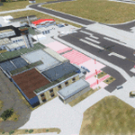
-Timisoara RO LRTR V-1 (Released Apr. 2017) for FSX-
This scenery is an update of the stock Airport (ICAO code: LRTR).
What to expect?
The entire airport has been updated with correct RWY, taxiways, aprons, markings, parkings, roads, some buildings, lights and vegetation. All objects are from stock ADE! Entire work and object placing has been done using a photo overlay image from Google Earth, yet don't expect a photoreal scenery. The used background image has been removed due to Google's copyright policy.
Due to using stock objects from library, don't expect perfect shape and colors of objects. I tried to customize the objects so that they look like the real ones. Basic shape and colors should match the real word buildings.
NOTE: Some 3rd party addon's might change ground textures or building textures.
| Filename: | LRTR_Update_10.zip |
| License: | Freeware |
| Added: | 26th March 2017, 20:35:59 |
| Downloads: | 1,440 |
| Author: | Gerald Krutsch |
| Size: | 1.27 MB |
| Category: Flight Simulator X - Scenery | |
| SKAR 2011 |
|
File Description:
El Eden Airport (Spanish: Aeropuerto El Eden) (IATA: AXM, ICAO: SKAR) is an international airport located in the Colombian city of Armenia. It handles all domestic flights to the major airports of the country and some international
destinations.
This file is the airport with the runway resized, airport buildings a correct VOR; also are included all the airport charts required to navigate in and out of this airport which are courtesy of: Areonautica Civil de Colombia and the
originals can be found at www.aerocivil.gov.co/ under Informacion Aeronautica click AIP; on AIP click Aerodromos then click at SKAR.
| Filename: | SKAR_2011.zip |
| License: | Freeware |
| Added: | 29th June 2011, 21:30:37 |
| Downloads: | 2,447 |
| Author: | Anwar Gonzalez |
| Size: | 2.04 MB |
| Category: Flight Simulator X - Scenery | |
| Kansas City Downtown Airport |
|
Images related to this file:
File Description:
Kansas City Downtown Airport. Re-uploaded after AVSIM file crash. Crash issues and other issues resolved from original upload.
| Filename: | Kansas_City_Downtown_Airport.zip |
| License: | Freeware |
| Added: | 13th August 2010, 22:33:39 |
| Downloads: | 1,809 |
| Author: | Mike Eppright |
| Size: | 3.08 MB |
| Category: Flight Simulator X - Scenery | |
| RAF Moreton In The Marsh - Gloucestershire, England |
|
File Description:
RAF Moreton-in-Marsh was a Royal Air Force station near Moreton-in-Marsh, Gloucestershire. It was opened in November 1940 and closed for operational flying in early 1948. The base remained in use as a relief runway and for training. After a period of care and maintenance, the Station was handed over to the Home Office in 1955.
The town's environs are quite flat and low-lying although it is situated at the northern extremity of the Cotswold Hills range. During World War II, a large area of this flat land to the east of the town was developed as an airfield and became the base of 21 OTU (Operational Training Unit) RAF, flying mainly Vickers Wellington bombers. It is highly likely that the airfield inspired the title of the radio show Much Binding in the Marsh. After all, two of its stars, Kenneth Horne and Richard Murdoch, served there as flying instructors.
| Filename: | RAF_Moreton_In_The_Marsh__Gloucestershire_England.zip |
| License: | Freeware |
| Added: | 1st February 2016, 10:07:46 |
| Downloads: | 229 |
| Author: | Terry Boissel |
| Size: | 1.74 MB |
| Category: Flight Simulator X - Scenery | |
| Isle of Man (Extras 1) |
|
Images related to this file:
File Description:
Extra 3D objects to fit Photographic Scenery of the Isle of Man. Covers the areas of Lang Ness, Scarlett Point(East), Chicken Rock, Calf of Man and 'mainland' Calf of Man viewing area.
Includes 6 lighthouses, Lang Ness, Chicken Rock and Thousla Rock have night lighting animation effects. Two fog horn effects, Lang Ness and Middle Calf Rock. Lang Ness Hotel and Golf complex, Bunkers and buildings for ex RAF Scarlett Chain Home base together with farm buildings and ruins of buildings on Calf Rock. Models function in FSX, P3D version 1.4, 2.0 and 2.1
| Filename: | Isle_of_Man_Extras_1.zip |
| License: | Freeware, limited distribution |
| Added: | 16th February 2014, 21:07:55 |
| Downloads: | 1,642 |
| Author: | Anthony R Meredith |
| Size: | 11.02 MB |
| Category: Flight Simulator X - Scenery | |
| RAF Fulbeck - Newark-on-Trent - Nottinghamshire, England |
|
File Description:
RAF Fulbeck is a former Royal Air Force station located 6.3 miles (10.1 km) east of Newark-on-Trent, Nottinghamshire and 10.9 miles (17.5 km) west of Sleaford, Lincolnshire, England.
The airfield is located about 106 miles (171 km) north-northwest of London and was opened in 1940 when it was used by both the Royal Air Force and United States Army Air Forces. During the war it was used primarily as troop carrier airfield for airborne units. It was closed in 1948 and was no longer used by the military and is now privately owned. You will require addon sceneries - see the included readme file for details.
| Filename: | RAF_Fulbeck__NewarkonTrent__Nottinghamshire_Englan.zip |
| License: | Freeware |
| Added: | 13th October 2015, 13:51:01 |
| Downloads: | 309 |
| Author: | Terry Boissel |
| Size: | 71.02 KB |


© 2001-2026 AVSIM Online
All Rights Reserved
Privacy Policy |