
Where Flight Simulation Enthusiasts Gather from Around the World!
AVSIM Library - Search Results

| Category: Flight Simulator X - Scenery | |
| SLLP |

|
File Description:
SLLP
El Alto International Airport (Spanish: Aeropuerto Internacional El Alto) (IATA: LPB, ICAO: SLLP) is an international airport located in El Alto, near the city of La Paz, in the La Paz Department of Bolivia. It serves national and international air traffic. The facility served as a focus city for the former Lloyd A���©reo Boliviano, Bolivia's national air carrier, and is a hub for Aerosur, currently the country's largest private airline.
| Filename: | SLLP.zip |
| License: | Freeware |
| Added: | 24th February 2011, 23:38:13 |
| Downloads: | 4,534 |
| Author: | Anwar Gonzalez |
| Size: | 26.7 KB |
| Category: Flight Simulator X - Scenery | |
| Pichlingersee - LOW1 |
|
Images related to this file:
File Description:
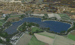
The Pichlingersee (LOW1) is a quarry pond near Linz (LOWL) in Austria (Upperaustria). The ILS approach to the runway 27 cross this lake. The helipad is in possession of Water Rescue Department and was not build on land. It was build "in water".
For the implementation of this area about 500 objects were set by hand from myself. Including not only trees and shrubs, but also signs, park benches, emergency call boxes (gernerated in gmax) etc at there right place. At night it was dark in real, so I does not create night texture. The scenery has 1.5 km ground imagery at 20cm per pixel and vary (hope) with the seasons.
Der Pichlingersee ist ein Baggersee in der Nhe von Linz (LOWL) in sterreich (Obersterreich). Der ILS Anflug auf die Landebahn 27 fhrt genau ber diesen See. Die Hubschrauberplattform gehrt der dortigen Wasserrettung und wurde nicht auf dem Land, sondern in den See hinein gebaut.
Fr die Umsetzung des Areals wurden von mir ber 500 Objekte von Hand gesetzt. Darunter nicht nur Bume und Strucher, sondern ebenso Schilder, Parkbnke, Notrufsulen (in gmax generiert) usw. an ihrem richtigen Platz. Da es dort in der Realitt nachts stockdunkel ist, habe ich auf Nachttexturen verzichtet. Die Szenerie hat eine 1.5 km Bodentextur mit 20cm/px und wechselt (hoffentlich) mit den Jahreszeiten.
| Filename: | Pichlingersee__LOW1.zip |
| License: | Freeware |
| Added: | 9th January 2013, 00:44:19 |
| Downloads: | 1,998 |
| Author: | Oliver Brandl |
| Size: | 54.71 MB |
| Category: Flight Simulator X - Scenery | |
| LOWK - Klagenfurt Airport - Austria ** Version 5 ** |
|
File Description:
Klagenfurt Airport (ICAO: LOWK), also known as Kaernten Airport, is the airport of Klagenfurt, the sixth-largest city in Austria.
It is located near the city centre of Klagenfurt and serves some flights to European leisure and metropolitan destinations.
Klagenfurt Airport consists of one small passenger terminal building which features some shops and restaurants as well as a visitors terrace.
The apron provides several stands for mid-sized planes such as the Airbus A320 as well as smaller general aviation aircraft.
As there are no jet bridges, busses are used for boarding.
In this version:
1. Errors from Version 3 and 4 were revised.
2. Flicker comes to an end.
3. The gates when Glock hangar and at the Christopherus - base open.
4. There are seasonal textures.
By Manfred Marbler.
| Filename: | LOWK__Klagenfurt_Airport___Austria___Version_5_.zip |
| License: | Freeware |
| Added: | 3rd May 2016, 13:33:05 |
| Downloads: | 4,096 |
| Author: | Manfred Marbler |
| Size: | 154.54 MB |
| Category: Flight Simulator X - Scenery | |
| EBCI Charleroi Brussels South Airport Update |
|
Images related to this file:
File Description:
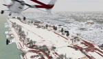
Update for EBCI Charleroi Brussels South Airport for FSX only based on charts of July 2010 (http://beluxvacc.org/)
Features:
- the new customer terminal including Parking 11, 12, 13 and 14
- the North taxiway connecting the cust terminal to the rwy 07 holding point N1
- all other updated taxiways and parkings/gates.
- photoscenery map for ground textures including night and seasonal variations. (best blending result with UT X Europe)
- the industrial area south of the airport
- all buildings visible at dense scenery level
| Filename: | EBCI_Charleroi_Brussels_South_Airport_Update.zip |
| License: | Freeware |
| Added: | 8th February 2011, 15:33:29 |
| Downloads: | 7,351 |
| Author: | Thibault Dosunmu |
| Size: | 114.4 MB |
| Category: Flight Simulator X - Scenery | |
| LOLO - Linz-Ost Flugplatz, Austria |
|
Images related to this file:
File Description:
The Airfield Linz-Ost located ca. 12 km eastern from Airport Linz-Hoersching (blue danube Airport Linz / LOWL) in Upper Austria. He located in the industry site of the town Linz direct Danube River. He has a grass runway with 940 m length and was used from April - October from glider and GA. -----
Der Flugplatz Linz-Ost liegt ca. 12 km oestlich vom Flughafen Linz-Hoersching (blue danube Airport Linz / LOWL) in Oberoesterreich und liegt im Industriegelaende der Stadt Linz direkt an der Donau. Er besitzt eine Gras Landebahn mit einer Laenge von 940m und wird in den Monaten April bis Oktober von Motor- und Segelflugzeugen genutzt.
| Filename: | LOLO__LinzOst_Flugplatz_Austria.zip |
| License: | Freeware |
| Added: | 30th January 2013, 19:42:57 |
| Downloads: | 3,053 |
| Author: | Oliver Brandl |
| Size: | 159.32 MB |
| Category: Flight Simulator X - Scenery | |
| LDZA Franjo Tudjman UPDATED SCENERY |
|
File Description:
Scenery has ALL THE LATEST AFCAD WITH NEW TERMINAL (as of 19 May 2017). Made with SBuilderX and ADE.
It has: Accurately 3D modelled new terminal (it gets the job done :D)
All the latest AFCAD with correct stands and stand numbers
Correct taxi signs on right places
Correct runway lighting systems
It doesn't have old terminal 3d modelled
| Filename: | LDZA_Franjo_Tudjman_UPDATED_SCENERY.zip |
| License: | Freeware, limited distribution |
| Added: | 19th May 2017, 19:18:50 |
| Downloads: | 2,464 |
| Author: | Noa Nikolic |
| Size: | 15.95 MB |
| Category: Flight Simulator X - Scenery | |
| LOGK - Kapfenberg Airport - Kapfenberg, Steiermark - Austria V1.0 |
|
File Description:
Kapfenberg Airport (German: Flugplatz Kapfenberg, ICAO: LOGK) is a public use airport located 3 kilometres (2 mi) east of Kapfenberg, Steiermark, Austria.
| Filename: | LOGK__Kapfenberg_Airport__Kapfenberg_Steiermark__A.zip |
| License: | Freeware |
| Added: | 14th August 2014, 21:05:30 |
| Downloads: | 2,287 |
| Author: | Manfred Marbler |
| Size: | 40.82 MB |
| Category: Flight Simulator X - Scenery | |
| China International Airports: ZGGG Guangzhou (Canton) |
|
Images related to this file:
File Description:
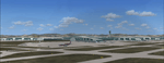
Scenery for the Guangzhou International Airport as it is in 2021. Airport layout corresponds to satellite images and recent charts, buildings made with GMAX.
| Filename: | China_International_Airports_ZGGG_Guangzhou_Canton.zip |
| License: | Freeware, limited distribution |
| Added: | 19th November 2021, 17:29:27 |
| Downloads: | 1,360 |
| Author: | Winfried Orthmann |
| Size: | 84.51 MB |
| Category: Flight Simulator X - Scenery | |
| MWCB - Charles Kirkconnell Intl. - Cayman Brac, Cayman Islands |
|
File Description:
Charles Kirkconnell International Airport, Cayman Brac 2015.
| Filename: | MWCB__Charles_Kirkconnell_Intl__Cayman_Brac_Cayman.zip |
| License: | Freeware |
| Added: | 9th January 2016, 15:02:24 |
| Downloads: | 1,843 |
| Author: | Gerome Bodden |
| Size: | 47.93 MB |
| Category: Flight Simulator X - Scenery | |
| KSJT - San Angelo Regional Airport / Mathis Field v1.0 |
|
Images related to this file:
File Description:
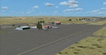
This scenery is the culmination of over 3 months of work. I have completely redesigned this airport to be as accurate as possible. Every apron, building, even light has been placed as accurately as possible. Includes custom terminal building, 3d lighting, and custom taxi/ramp markings. Please bear with any problems or inaccuracies that arise as this is my First scenery project. By Matt LaMay.
| Filename: | KSJT__San_Angelo_Regional_Airport__Mathis_Field_v1.zip |
| License: | Freeware, limited distribution |
| Added: | 10th May 2015, 13:33:07 |
| Downloads: | 557 |
| Author: | Matt LaMay |
| Size: | 20.08 MB |
© 2001-2026 AVSIM Online
All Rights Reserved
Privacy Policy |