
Where Flight Simulation Enthusiasts Gather from Around the World!
AVSIM Library - Search Results

| Category: Flight Simulator X - Scenery | |
| OERK Photoreal - King Khalid International Airport - Riyadh, Saudi Arabia |

|
File Description:
This is a Photoreal Scenery for Riyadh's King Khalid International Airport. Note that this is only a Photoreal Scenery and not an AFCAD (airport design file). Tested on FSX and P3D. Might work on FS2004 as well, you might want to give it a try. Read "readme.txt" for more information.
| Filename: | OERK_Photoreal__King_Khalid_International_Airport_.zip |
| License: | Freeware, limited distribution |
| Added: | 7th December 2015, 22:08:36 |
| Downloads: | 3,722 |
| Author: | Shafat Hasan |
| Size: | 2.19 MB |
| Category: Flight Simulator X - Scenery | |
| SVAN - Anaco, Venezuela |
|
Images related to this file:
File Description:
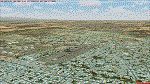
Located to the east of Venezuela, With photo-terrain scenery from satellite imagery.
This scenery is only for FSX SP1 SP2 or Acceleration, is not compatible with previous versions.
Includes custom buildings, you will find also standard FSX library objects.
| Filename: | SVAN__Anaco_Venezuela.zip |
| License: | Freeware |
| Added: | 5th October 2013, 18:27:16 |
| Downloads: | 1,378 |
| Author: | Pedro Luis Paz |
| Size: | 23.07 MB |
| Category: Flight Simulator X - Scenery | |
| SVAY - Araya, Venezuela |
|
Images related to this file:
File Description:
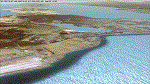
Located to the east of Venezuela, With photo-terrain scenery from satellite imagery.
This scenery is only for FSX SP1 SP2 or Acceleration, is not compatible with previous versions.
Includes custom buildings, you will find also standard FSX library objects. Isla de Coche (SVIE) and Cubagua are also included.
| Filename: | SVAY__Araya_Venezuela.zip |
| License: | Freeware |
| Added: | 5th October 2013, 18:27:28 |
| Downloads: | 1,209 |
| Author: | Pedro Luis Paz |
| Size: | 48.85 MB |
| Category: Flight Simulator X - Scenery | |
| North Central Ecuador v3, including SEQM (SEQU) and SEIB |
|
Images related to this file:
File Description:
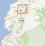
FSX/P3D Version 3 of this scenery is a completely new build of SEQM from the ground up. The entire complex is rendered using FSX objects along with the new highway that connects to the highway infrastructure with AI road traffic. The airport is now at a mean altitude that better blends with the newly included NASA SRTM GL1 30m mesh for the region. The tower is at the correct altitude. Buildings use more accurate footprints, new models, floating jetways, and updated landclass, and work seamlessly with the roads added by FTX Global/Vector. Lakes are corrected within roughly 100 square miles. Although the Ibarra/Atahualpa (SEIB) airport no longer exists, there is an option to add it back. Startup files are included to fly from the lakes and the Ibarra/Atahualpa (SEIB) airport. As a “bonusâ€, SEQU was restored in this version, because much of the footprint of the airport still remains as part of its conversion to a park. As such, a custom and fully functional SEQU is included for users who would like to revisit the old airport. AI Traffic can be restored at SEQU by simply using the "Reversed SEQU-SEQM AI Traffic" option. Scenery was created using Airport Design Editor X v1.76.6715, SBuilderX 3.13, and the FSX Object Placement Tool. Scenery objects were added and modified from stock FSX scenery to resemble as closely as possible the actual airport. Bill Leaming's Ramp Lights for P3D/FSX illuminate the aprons.
| Filename: | North_Central_Ecuador_v3_including_SEQM_SEQU_and_S.zip |
| License: | Freeware |
| Added: | 22nd March 2020, 22:13:37 |
| Downloads: | 4,102 |
| Author: | Carlyle Sharpe |
| Size: | 29.44 MB |
| Category: Flight Simulator X - Scenery | |
| SLET - El Trompillo Airport - Santa Cruz de la Sierra, Bolivia |
|
File Description:
El Trompillo Airport (IATA: SRZ, ICAO: SLET) is located in the south part of Santa Cruz de la Sierra, Bolivia, about 2 km (1.25 miles) away from the central plaza. Airport type:(Public / Military).
After a series of improvements, in June 3, 2014 Airport regained its status as an international airport by converting to Santa Cruz de la Sierra in Bolivia the only city with two international airports, international airport suitable as retention and/or support times of high demand in the Viru Viru Airport (ICAO: SLVR) can not supply completely.
The airport operates 24 hours and resides at an elevation of 1,371 ft (418 m) above mean sea level. Have one runway designated 15/33 with an asphalt surface measuring 8,967 by 114.82 ft (2,733 m by 35 m), El Trompillo Tunnel for vehicles, passes under the runway and connects the 4th ring (considered the most important highway in the city).
Compatible with both FSX and P3D.
| Filename: | SLET__El_Trompillo_Airport__Santa_Cruz_de_la_Sierr.zip |
| License: | Freeware |
| Added: | 19th November 2015, 09:49:14 |
| Downloads: | 1,839 |
| Author: | Marcos A. Rivas Torrez |
| Size: | 16.68 MB |
| Category: Flight Simulator X - Scenery | |
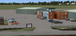
| KNYG - Quantico MCAF (Tuner Field) - Virginia |
|
Images related to this file:
File Description:
This is a complete re-work of the airport.Created with Airport Design Editor by ScruffyDuck Software using current FAA documentation and Google Earth measurements, this package offers a replacement for FSX's stock airport. All these enhancements are as close to the real airport as I can get with stock library objects and custom models.
| Filename: | KNYG__Quantico_MCAF_Tuner_Field__Virginia.zip |
| License: | Freeware |
| Added: | 17th August 2014, 22:26:38 |
| Downloads: | 320 |
| Author: | Wayne Roberts |
| Size: | 32.75 KB |
| Category: Flight Simulator X - Scenery | |
| Ercan Airport (LCEN) North Cyprus. |
|
File Description:
Created with 3dsMax from scratch, accurately detailed and
realisticly represents the North Cyprus Airport which has
undergone major modernisation and upgrading during the
recent years.
This is a complete scenery with animations, effects,
photo-real terrain and night texturing together with ILS and navaids.
| Filename: | Ercan_Airport_LCEN_North_Cyprus.zip |
| License: | Freeware |
| Added: | 3rd March 2008, 10:54:05 |
| Downloads: | 23,169 |
| Author: | Serdar Nuzhet |
| Size: | 4.68 MB |
| Category: Flight Simulator X - Scenery | |
| Victoria, Canada including US Southern Gulf Islands and San Juan Islands - Part 2 of 2 |
|
Images related to this file:
File Description:
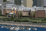
FSX-only version of Victoria, Canada area scenery including the Southern Gulf Islands and the San Juan Islands of the US. Includes automated installer and configurator by Scot Fraser.
Features:
-accurate shorelines, lakes and streams;
-landclass;
-FSX multi-LOD mesh with 10m maximum resolution;
-complete road network with moving traffic;
-railroads;
-utility corridors;
-marinas and ferry terminals;
-many static boats, including a custom model of the Canada Coast Guard ship Sir Wilfred Laurier;
-detailed models of major buildings and the Ogden Point Terminal;
-many bridges;
-nearly 300 marine lights; and corrected antennae locations.
Facilities include Don Grovestine's famous CYYJ (Victoria International Airport); 12 other Canadian land-based airports: Butler Field, Duncan (CAM3), Gaines, Hastings, Hudson Island, James Island, Thomas, Village Bay, Raven Field (CML2), Saltspring, Sidney Island, Whiskey Point; 20 US airports Blakely (38WA), Burden (61WA), Center Island (79WA), Clam Harbor (WA35), Crane Island, Decatur Shores (WN07), Decatur-Jones (WA18), Waldronaire (90WA), Orcas Island (KORS), Friday Harbour (KFHR), Lopez Island (S31), Pile Point, Roche Harbor (WA09), Shaw Island, Stuart Island Airpark (7WA5), Stuart Island West (2WA3), Wilding (6WA5), Windsock (4WA4); 12 floatplane facilities: Bedwell (CAB3), Fisherman's Bay (WA81), Friday Harbor (W33), Ganges (CAX6), Maple Bay, Mayne (CAW7), Port Washington (CAP8), Roche Harbor (W39), Rosario (W49), Shawnigan Lake (CAV8), Victoria Harbour (CYWH), Victoria International (CAP5) and Westsound, Orcas (WA83) - many with AI traffic; 9 heliports: Ganges (CAL7), Mayne (CBF5), Camel Point (CBF7), Jubilee (CBK8), Victoria General (CBW7) Madrona Bay (CBW9), Shoal Point (CBZ7), Mount Belcher (CMBH).
AI models include the DHC-2 floatplane in local liveries, a cruise ship model (by Mitsuya Hamaguchi) and two repaints, pilot boat, and small boats (by Larry Silsbee).
Ultimate Terrain X compatible (not required). Users of Vancouver+ for FSX will also get additional cruise ship traffic and additional floatplane and helicopter traffic. Full documentation. By Don Grovestine, Jon Patch and Holger Sandmann. Many other contributors: see documentation. Part 2 of 2 - you also need file vicenh7a.zip
| Filename: | Victoria_Canada_including_US_Southern_Gulf_Islands.zip |
| License: | Check within download |
| Added: | 29th January 2010, 21:21:49 |
| Downloads: | 23,164 |
| Author: | Don Grovestine, Jon Patch and Holger Sandmann |
| Size: | 59.08 MB |
| Category: Flight Simulator X - Scenery | |
| UK Airfields Volume 23 |
|
Images related to this file:
File Description:
Volume 23 consists firstly of a small grass strip Audley End X3AE, 1nm Southwest of Saffron Walden. Second is Beccles EGSM, 4nm Eastsoutheast of Stowmarket and 5nm North of Ipswich. This was once a helicopter terminal for the North Sea Gas Fields and was made at the request of Gerry Francis who used to fly from there. Finally I offer Gamston EGNE, the bustling regional airport of Retford which is 2nm to the North.
| Filename: | UK_Airfields_Volume_23.zip |
| License: | Freeware |
| Added: | 25th June 2011, 22:59:05 |
| Downloads: | 1,275 |
| Author: | Alf Denham |
| Size: | 17.69 MB |
| Category: Flight Simulator X - Scenery | |
| Alf's UK airfields Volume 11 |
|
File Description:
This set of UK airfields for use with FSX generic scenery is Sheffield City Airport EGSY, Sutton Bank XSUT, home of Yorkshire Gliding Club, set on the edge of an escarpment and finally Welshpool EGCW, Mid Wales Airport.
| Filename: | Alfs_UK_airfields_Volume_11.zip |
| License: | Freeware |
| Added: | 25th August 2008, 23:46:27 |
| Downloads: | 3,398 |
| Author: | Alf Denham |
| Size: | 10.97 MB |
© 2001-2026 AVSIM Online
All Rights Reserved
Privacy Policy |