
Where Flight Simulation Enthusiasts Gather from Around the World!
AVSIM Library - Search Results

| Category: Flight Simulator X - Scenery | |
| FSX Scenery--Landclass For Santa Barbara |

|
Images related to this file:
File Description:

FSX Scenery--Landclass For Santa Barbara, CA. Scenery and landclass for Santa Barbara California. This is a detailed landclass and scenery add-on to use with FSX CCCFSX Scenery by Al Wheeler. The scenery and landclass will work without adding Al's scenery. The changes that have been created will make for excellent VFR flying. Hundreds of objects have been added that reflect the real layout and scenery for this location.
| Filename: | FSX__SceneryLandclass_For_Santa_Barbara.zip |
| License: | Freeware |
| Added: | 5th September 2012, 00:23:45 |
| Downloads: | 540 |
| Author: | Charles Reid |
| Size: | 5.24 MB |
| Category: Flight Simulator X - Scenery | |
| German Airfields Northwest Update |
|
File Description:
Update for the airfields in Northwest Germany
EDKD, EDKF, EDKH, EDKM, EDKO, EDKP, EDKR, EDKZ, EDLA,
EDLB, EDLH, EDLI, EDXE, Rheinermark, Schneverdingen.
This update is for use with the standard landclass textures.
| Filename: | German_Airfields_Northwest_Update.zip |
| License: | Freeware |
| Added: | 3rd February 2016, 19:11:54 |
| Downloads: | 535 |
| Author: | Juergen Wolf |
| Size: | 35.23 KB |
| Category: Flight Simulator X - Scenery | |
| German Airfields Southeast Vol2 Update |
|
File Description:
Update for the airfields in Souteast Germany
EDMP, EDNG, EDNJ, EDNO, EDOP, EDNQ, EDNT, EDPA, EDPE, EDPG,
EDPT, EDPY, EDTH.
This update is for use with the standard landclass textures.
| Filename: | German_Airfields_Southeast_Vol2_Update.zip |
| License: | Freeware |
| Added: | 3rd February 2016, 19:12:25 |
| Downloads: | 490 |
| Author: | Juergen Wolf |
| Size: | 182.62 KB |
| Category: Flight Simulator X - Scenery | |
| La Durance - French River - |
|
File Description:
The scene of the river Durance, Hautes Alpes and Alpes de Haute-Provence (France).
Durance is rooted at the foot of the Summit of Angels, 2390 m, south of Montgen�¨vre, to the confluence with the Rhone. Durance runs 305 km.
This scene represents the river durance and its floodway (EDF) of the dam of Serre-pon�§on to the Rhone, for Durance, to the pond of Berre EDF for the Grand Canal.
Some changes landclass more truthful were modeled.
This scene was designed for FSX default (SP1), it has not been tested with FS9.
| Filename: | La_Durance__French_River_.zip |
| License: | Freeware |
| Added: | 22nd December 2010, 00:55:31 |
| Downloads: | 1,840 |
| Author: | CLAUZE Norbert |
| Size: | 3.77 MB |
| Category: Flight Simulator X - Scenery | |
| USNS Patuxent - Textures fixes |
|
File Description:
Put these seven textures into the "texture" folder of USNS Patuxent.
| Filename: | USNS_Patuxent__Textures_fixes.zip |
| License: | Freeware |
| Added: | 13th May 2016, 18:13:22 |
| Downloads: | 159 |
| Author: | Antonio Diaz |
| Size: | 797.5 KB |
| Category: Flight Simulator X - Scenery | |
| Springfield-Branson National Airport KSGF--New Midfield Terminal and Airfield Update |
|
Images related to this file:
File Description:
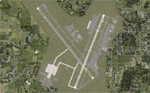
This project adds the new midfield terminal and taxiways to the renamed Springfield-Branson National Airport and updates the position of buildings and taxiways from the stock AFCAD. The airport is currently served by American Airlines (Chicago-Dallas), Allegiant (Los Angeles-Las Vegas-Orlando-Tampa-Phoenix), Delta (Atlanta-Detroit-Memphis-Minneapolis) and United (Chicago-Denver). Scenery created and edited using Airport Design Editor X v1.47.07, and SBuilderX 3.13.
| Filename: | SpringfieldBranson_National_Airport_KSGFNew_Midfie.zip |
| License: | Freeware |
| Added: | 6th September 2010, 01:28:20 |
| Downloads: | 1,809 |
| Author: | Carlyle Sharpe |
| Size: | 2.36 MB |
| Category: Flight Simulator X - Scenery | |
| DL_NFI.zip |
|
File Description:
The Scenery includes a Fotoreal orientation of the "Nordfriesischen Inseln" in the north of Germany (North Sea) including the island Helgoland for the FSX.
The Scenery is based on Google Earth Satellite images.
Islands:
Sylt, Amrum, Föhr, Lageness, Hooge, Pellworm, Nordstrand and Helgoland .
Textures are partially with LOD 14 (2,4 m/pix) . The island Sylt is in LOD 13 (4.7 m/pix) .
Shore lines are included for Sylt (West coast) und Amrum (West coast).
In addition 6 Objects:
- Lighthouse from Hörnum (Sylt)
- Lighthouse from Kampen ( Sylt)
- Lighthouse from Amrum
- A ballon on the beach of Kampen (Sylt).
- Sheeps on the little island auf Hooge ( who can find them ?)
| Filename: | DL_NFIzip.zip |
| License: | Freeware |
| Added: | 4th October 2008, 20:36:37 |
| Downloads: | 7,286 |
| Author: | Dietmar Loleit |
| Size: | 12.65 MB |
| Category: Flight Simulator X - Scenery | |
| Lake Union |
|
Images related to this file:
File Description:
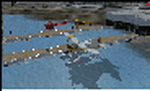
This was made using Airport Facilitator X and Instant Scenery and is scenery for Lake Union. Lake Union is located in Seattle, Washington. I also made scenery for Kenmore air Harbor (W55) which is a seaplane base that is also located on Lake Union. I added two water planes at the dock and also made several more docks with boats. This was based off of satellite imagery. Please read the read me for instructions on how to install. This is for Flight Simulator X only. By Tyler Lawrence
| Filename: | Lake_Union.zip |
| License: | Freeware |
| Added: | 2nd January 2012, 20:59:01 |
| Downloads: | 899 |
| Author: | Tyler Lawrence |
| Size: | 8.87 MB |
| Category: Flight Simulator X - Scenery | |
| East Mesa and Phoenix Sky Harbor Airport Updates |
|
File Description:
KSDL:
Added ILS and Terminal with Jetways and Corrected Gate Numbers
KFFZ:
Added ILS and a small gate (NO JETWAY)
KCHD:
Added ILS
KPHX:
ADDED ILS TO 25R (DO NOT INSTALL UNLESS WANTED)
There are 4 airport updates in this package. I added ILS to all the regional and municipal airports in MESA, AZ that don't have ILS (most CAT III).
| Filename: | East_Mesa_and_Phoenix_Sky_Harbor_Airport_Updates.zip |
| License: | Freeware |
| Added: | 2nd December 2013, 05:30:00 |
| Downloads: | 359 |
| Author: | Alex Kulak |
| Size: | 73.12 KB |
| Category: Flight Simulator X - Scenery | |
| NWT Landscape - Canada |
|
File Description:
Elevation data (mesh-Lod10 - 38m), land cover, water polygons, rivers, stream lines, lanes and shorelines around airports of Northwest Territories, Canada.
| Filename: | NWT_Landscape__Canada.zip |
| License: | Freeware, limited distribution |
| Added: | 9th February 2011, 17:43:21 |
| Downloads: | 3,349 |
| Author: | Gilles Gauthier |
| Size: | 89.42 MB |
© 2001-2026 AVSIM Online
All Rights Reserved
Privacy Policy |