
Where Flight Simulation Enthusiasts Gather from Around the World!
AVSIM Library - Search Results

| Category: Flight Simulator X - Scenery | |
| GB-0112 - RAF Bassingbourn - Cambridgeshire, England |

|
File Description:
RAF Bassingbourn is a former Royal Air Force station located in Cambridgeshire approximately 3 mi (5 km) north of Royston, Hertfordshire and 11 mi (18 km) south west of Cambridge, Cambridgeshire, England.
RAF Bassingbourn was constructed by John Laing & Son between 1937 and 1939 in the parishes of Wendy and Bassingbourn immediately to the west of the A14 (now the A1198) road. The site selected was low ground between several tributaries of the River Cam. The area had been long cleared of forest and tended to be swampy and unstable, and because the boggy ground produced a persistent mist over the large meadow the site was considered ideal for airfield camouflage.
During the Second World War it served first as an RAF station and then as a bomber airfield of the Eighth Air Force, of the United States Army Air Forces (USAAF). It remains the home of the Tower Museum Bassingbourn. From 19 August 1942 to 25 June 1945, Bassingbourn served as headquarters for the 1st Combat Bombardment Wing of the 1st Bomb Division. It was assigned USAAF designation Station 121.
The RAF resumed occupation of Bassingbourn on 26 June 1945, the airfield was officially returned on 10 July 1945. The station became one of the main airfields for long-range transport aircraft. In 1948 and 1949 Avro York, Avro Lancaster and Douglas Dakota aircraft from the base took part in the Berlin Airlift, a massive operation transporting essential commodities to the beleaguered city.
In February 1952, RAF Bassingbourn received its first allocation of English Electric Canberra bombers and became the first jet bomber operational conversion unit (OCU) in the world. Canberras operated from Bassingbourn for 17 years and one of the aircraft is on static display in the Barracks. From 1963 to 1969 the Joint School of Photographic Interpretation was also located there.
On 29 August 1969, the last RAF Commanding Officer, Sqn Ldr A.M. McGregor MBE, turned over the station to the British Army as Bassingbourn Barracks.
The barracks were established, on the site of the former RAF Bassingbourn airfield, in January 1970, as the new Depot for the Queen's Division. The depot was responsible for training recruits undergoing their 19-week basic training before joining a regular battalion; in 1993 the Barracks were re-designated the home of the "Army Training Regiment, Bassingbourn" and remained as such for nearly 20 years. Bassingbourn Barracks closed as an army training location in August 2012.
The site was reopened for training Libyan soldiers in 2014 but closed down the same year.
Since approximately 1970 the site has retained its RAF links by being the home of 2484 (Bassingbourn) Squadron Air Training Corps.
| Filename: | GB0112__RAF_Bassingbourn__Cambridgeshire_England.zip |
| License: | Freeware |
| Added: | 30th May 2016, 11:01:25 |
| Downloads: | 321 |
| Author: | Terry Boissel |
| Size: | 1.58 MB |
| Category: Flight Simulator X - Scenery | |
| FSX/FS2002/FS2004 Whole The Netherlands ,Europe Thermals Scenery |
|
File Description:
FSX/FS2002/FS2004 Whole The Netherlands ,Europe Thermals Scenery
This file adds some thermals to gliders flights over whole Netherlands Region,Europe.
It is freeware.
Volta Redonda,Brazil - October-15-2007
By Francisco Vargas.
E-mail: [email protected]
| Filename: | FSXFS2002FS2004_Whole_The_Netherlands_Europe_Therm.zip |
| License: | Freeware |
| Added: | 6th January 2008, 17:57:52 |
| Downloads: | 709 |
| Author: | Francisco Augusto Vargas Carneiro |
| Size: | 312.46 KB |
| Category: Flight Simulator X - Scenery | |
| RAF Lindholme (1940s) |
|
File Description:
RAF Lindholme is located 3.9 miles (6.3 km) south of Thorne and 6.9 miles (11.1 km) north east of Doncaster and was initially called RAF Hatfield Woodhouse and started life as an
expansion scheme aerodrome built on the wide expanse of Hatfield moors, some five miles east of Doncaster. The site, to the east of the A614 Thorne to Bawtry road, was a mile
south of the small village of Hatfield Woodhouse, the name first selected for the new station. Work began in the spring of 1938 taking in approximately 250 acres (1.0 km2) of
pasture for the airfield itself and a further 150 for the camp and support facilities.
RAF lindholme had a long a varied career, details of which cam be found at:- https://en.wikipedia.org/wiki/RAF_Lindholme
Source:Wikipedia
| Filename: | RAF_Lindholme_1940s.zip |
| License: | Freeware |
| Added: | 4th March 2017, 19:57:23 |
| Downloads: | 87 |
| Author: | Terry Boissel |
| Size: | 1.24 MB |
| Category: Flight Simulator X - Scenery | |
| KBCT - Boca Raton Airport - Florida, USA *Update* |
|
Images related to this file:
File Description:
Update to Art Poole's (with his permission) Boca Raton Scenery package for FSX (can be found here: http://library.avsim.net/esearch.php?DLID=156412):
-Short EMAS System added to the end of runway 5
-Coming soon: Boca Raton's very own customs facility
Just replace the KBCT_ADE_AP.bgl file with the new KBCT_EMAS_ADE.bgl file.
| Filename: | KBCT__Boca_Raton_Airport__Florida_USA_Update.zip |
| License: | Freeware, limited distribution |
| Added: | 11th March 2016, 17:14:41 |
| Downloads: | 435 |
| Author: | Yisrael Wealcatch |
| Size: | 15.21 KB |
| Category: Flight Simulator X - Scenery | |
| KSOW - Show Low, AZ |
|
Images related to this file:
File Description:

FSX scenery: KSOW Show Low, AZ. Simple addon cars, people, aircraft. Very challenging airport during low visibility conditions.
| Filename: | KSOW__Show_Low_AZ.zip |
| License: | Freeware |
| Added: | 25th January 2011, 14:56:07 |
| Downloads: | 238 |
| Author: | jimmy R martin |
| Size: | 280.09 KB |
| Category: Flight Simulator X - Scenery | |
| California Missions Pak 3 |
|
Images related to this file:
File Description:

FSX Scenery--California Missions Pak 3. This is the third scenery package of California Missions for FSX, and includes all 22 of the California Missions (CA). Custom designed buildings with photorealistic textures, night textures, and satellite image for the grounds. This scenery has been tested on FSX Gold Edition (FSX Deluxe and Acceleration Expansion Pack), FSGenesis 9.6 terrain mesh, and Win7 operating system. Requires RWEOBJv5.zip & RWEOBJc5.zip (or later) Object Libraries. By Ron Ezra.
| Filename: | California_Missions_Pak_3.zip |
| License: | Freeware |
| Added: | 9th January 2016, 23:42:40 |
| Downloads: | 626 |
| Author: | Ron Ezra |
| Size: | 49.46 MB |
| Category: Flight Simulator X - Scenery | |
| California Central Coast |
|
File Description:
This Scenery covers the California Central Coast from Paso Robles in the North to Santa Barbara in the South with about 22 points of interest. This is the same area covered by my CCC scenery for FS9.
| Filename: | California_Central_Coast.zip |
| License: | Freeware |
| Added: | 25th April 2008, 21:16:21 |
| Downloads: | 3,687 |
| Author: | Al Wheeler |
| Size: | 5.28 MB |
| Category: Flight Simulator X - Scenery | |
| Death Valley National Park - California, USA |
|
Images related to this file:
File Description:
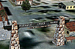
FSX Scenery--Death Valley. This scenery covers several areas of Death Valley National Park (CA). See the World's lowest golf coarse at Furnace Creek Ranch, the moving rocks at the RaceTrack, Scotty's Castle, Panamint Spring, and Stovepipe Wells. Custom designed buildings with photorealistic textures, night textures, and satellite image for the grounds. This scenery has been tested on FSX Gold Edition (FSX Deluxe and Acceleration Expansion Pack), FSGenesis 9.6 terrain mesh, and Win7 operating system. Requires RWEOBJv5.zip & RWEOBJc5.zip (or later) Object Libraries. By Ron Ezra.
| Filename: | Death_Valley_National_Park__California_USA.zip |
| License: | Freeware |
| Added: | 13th January 2016, 22:23:10 |
| Downloads: | 454 |
| Author: | Ron Ezra |
| Size: | 5.53 MB |
| Category: Flight Simulator X - Scenery | |
| Truckee-Tahoe Airport (KTRK) |
|
File Description:
This is a scenery update Truckee-Tahoe airport in Northern California. Taxiways, runways, buildings, and other aspects were updated using satellite images from Google Earth. The glider field at the north end of the airport was also added. Default scenery objects from the FSX libraries were used. Compiled using Airport Design Editor. View Readme file for installation and notes.
| Filename: | TruckeeTahoe_Airport_KTRK.zip |
| License: | Freeware |
| Added: | 22nd November 2008, 02:21:50 |
| Downloads: | 934 |
| Author: | Phillip Coyle |
| Size: | 223.44 KB |
| Category: Flight Simulator X - Scenery | |
| Baikonur Cosmodrome (UAON) Plus |
|
Images related to this file:
File Description:
The scenery includes many airports and locations, including UAON and the Baikonur Cosmodrome where Russia launches all spacecraft. The details are stunning. Some airports are gravel, and some are military use only. I am very sorry to report that the author of this excellant work did not credit himself anywhere within the Russia text document included within this zip file. Google translate pulled only little bits of installation data, but no names. Perhaps he was concerned of prosecution, but I commend him in any case. I do not think any of this is illegal in any way based on today's Google Earth data and our ability to see all the things included within this work. It is truly a beautifully done piece of work, and something I have searched for since scenery were available. It was listed as Freeware without restrictions. This a completely previously unknown scenery compilation found through extensive searches and is original in all respects, designed for FSX.
| Filename: | Baikonur_Cosmodrome_UAON_Plus.zip |
| License: | Freeware |
| Added: | 9th November 2019, 21:47:18 |
| Downloads: | 507 |
| Author: | Douglas E. Trapp |
| Size: | 8.36 MB |
© 2001-2026 AVSIM Online
All Rights Reserved
Privacy Policy |