
Where Flight Simulation Enthusiasts Gather from Around the World!
AVSIM Library - Search Results

| Category: Flight Simulator X - Scenery | |
| EGPD - Aberdeen Airport - Aberdeen, Scotland, UK |

|
Images related to this file:
File Description:
This scenery update is for Aberdeen airport and made only for FSX: runway 16/34 now at its new length, new ATC tower and associated buildings, taxiways and taxi signs updated to the latest charts, fire station added and many other scenery objects included to further enhance this airport, airport views are from the roof of the control tower (when in tower view) please view the readme before installation.
| Filename: | EGPD__Aberdeen_Airport__Aberdeen_Scotland_UK.zip |
| License: | Freeware, limited distribution |
| Added: | 9th June 2015, 15:06:22 |
| Downloads: | 12,509 |
| Author: | Craig Scott |
| Size: | 607.61 KB |
| Category: Flight Simulator X - Scenery | |
| St. Kilda |
|
File Description:
St. Kilda is an archipeligo of islands off the western coast of Scotland. By defult, FSX has blank sea in this area but with this scenery file you can explore the remotest part of the UK. Fly from Benecula on a heading of 310° for about 45 miles. If you see nothing then you need this file.
| Filename: | St_Kilda.zip |
| License: | Freeware |
| Added: | 9th August 2008, 22:27:39 |
| Downloads: | 1,756 |
| Author: | Mike Dalgleish |
| Size: | 258.71 KB |
| Category: Flight Simulator X - Scenery | |
| Fantasy of Flight Scenery |
|
Images related to this file:
File Description:
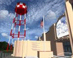
Fantasy of Flight Airport Scenery for FSX SP2 (version 1.0) by Vassilios Dimoulas
Airport details: The scenery represents FA08 Polk City, the private airport housing the "Fantasy of Flight - World's Greatest Aircraft Collection". The collection is owned by the legendary Kermit Weeks and includes over 40 rare and vintage arcraft, many of them restored to flying condition. For more information you may visit http://www.fantasyofflight.com/.
The scenery includes 32 custom built objects in an effort to represent the actual buildings and objects around the field as best as possible. Nearly everything is included except the "Wing Walk Air" attraction. The surrounding grounds are made by landclass polygons. trying to represent the vegetation. A photoreal version might be made in the future.
| Filename: | Fantasy_of_Flight_Scenery.zip |
| License: | Freeware |
| Added: | 22nd June 2012, 03:32:26 |
| Downloads: | 2,143 |
| Author: | Vassilios Dimoulas |
| Size: | 7.95 MB |
| Category: Flight Simulator X - Scenery | |
| KFFZ - Falcon Field - Mesa, Arizona |
|
Images related to this file:
File Description:
Once again I have finally had enough of a bad airfield that I am very familiar with! FSX default KFFZ is "BAD" so here you go!, a much improved Airfield!. Falcon started out as a WW2 British training field and some day I will make a version of it, till then here is my rendition of KFFZ as of 2013, corrected apron's and taxiways to be current, added taxi sighs (so you know what taxiway your on, and lots more!, Hope you like it?, ENJOY!..
| Filename: | KFFZ__Falcon_Field__Mesa_Arizona.zip |
| License: | Freeware |
| Added: | 9th April 2013, 06:50:51 |
| Downloads: | 1,776 |
| Author: | Darrell Meadr |
| Size: | 28.47 MB |
| Category: Flight Simulator X - Scenery | |
| KEKM - Elkhart Municipal Airport - Elkhart, Indiana |
|
Images related to this file:
File Description:
Elkhart Municipal Airport serves Elkhart and Elkhart County and is owned by the City Of Elkhart, Indiana. The airport has more than one runway. The longest is a paved runway extending 6500 feet. The facility is at an elevation of 778 feet at a distance of about 3 miles from Elkhart. For the enjoyment of the FS community, by John B. Loney, Jr.
| Filename: | KEKM__Elkhart_Municipal_Airport__Elkhart_Indiana.zip |
| License: | Freeware, limited distribution |
| Added: | 22nd March 2013, 19:01:03 |
| Downloads: | 571 |
| Author: | John B. Loney, Jr. |
| Size: | 86.56 MB |
| Category: Flight Simulator X - Scenery | |
| Cornelius-Moore (Polk County) Airport 4A4 |
|
Images related to this file:
File Description:

Cornelius-Moore (Polk County) airport-4A4 is situated about 5nm east of Cedartown, Georgia U.S.A.
| Filename: | CorneliusMoore_Polk_County_Airport__4A4.zip |
| License: | Freeware |
| Added: | 16th September 2011, 14:18:57 |
| Downloads: | 536 |
| Author: | Alf Denham |
| Size: | 22.55 MB |
| Category: Flight Simulator X - Scenery | |
| Hawes Aerial Operations Facility |
|
Images related to this file:
File Description:

Hawes Aerial Operations Facility is a reimagined version of an abandoned World War II auxiliary airstrip formerly known as Hawes AAF Aux #1. It was built in the mojave desert, just east of Edwards AFB (then Muroc AAF) during WWII as one of 4 satellite fields for Victorville AAF. After the war, Hawes as used as a private civilian airfield until it's closure in the early 1960's. It is now reborn in FSX as a UAV base by Nevada Systems. Due to it's location in the Mojave desert and the presence of many thermals in FSX, it was also used in production of the Aeroworks ARX-1 civilian glider concept. This scenery uses many custom macros as well as default macros from the Acceleration Expansion Pack, which is required for best performance. Scenery and custom macros by Joshua B. Nyhus and Jason L. Terry
| Filename: | Hawes_Aerial_Operations_Facility.zip |
| License: | Freeware |
| Added: | 7th December 2012, 15:58:27 |
| Downloads: | 538 |
| Author: | Jason L Terry and Josh Nyhus |
| Size: | 5.91 MB |
| Category: Flight Simulator X - Scenery | |
| KHIB - Range Regional (Hibbing) Airport - Hibbing, Minnesota |
|
Images related to this file:
File Description:
FSX Scenery - Range Regional Airport (IATA: HIB, ICAO: KHIB, FAA LID: HIB) is a public use airport located four nautical miles (5 mi, 7 km) southeast of the central business district of Hibbing, in Saint Louis County, Minnesota, United States. It was formerly known as Chisholm-Hibbing Airport or Chisholm-Hibbing Municipal Airport. The airport is mostly used for general aviation but is also served by one commercial and one charter airline. Scheduled passenger service is subsidized by the Essential Air Service program. Created for your flying pleasure by John B. Loney, Jr.
| Filename: | KHIB__Range_Regional_Hibbing_Airport__Hibbing_Minn.zip |
| License: | Freeware, limited distribution |
| Added: | 29th July 2014, 11:43:33 |
| Downloads: | 496 |
| Author: | John B. Loney, Jr. |
| Size: | 15.58 MB |
| Category: Flight Simulator X - Scenery | |
| Knoxville Municipal Airport KOXV |
|
Images related to this file:
File Description:
FSX Scenery - The Knoxville Municipal Airport, (KOXV) renamed Jim Bellamy Field, serves the greater Knoxville community and the surrounding areas of Marion County, Iowa. The airport is comprised of 120 acres, and is located at the southern edge of Knoxville, adjacent to the Highway 14 & Highway 5/92 interchange. The 4,000 foot (by 75 foot) single runway is constructed of concrete, with parallel taxiway. The facility is at an elevation of 928 feet at a distance of about 2 miles from Knoxville. Created for your flying pleasure by John B Loney, Jr.
| Filename: | Knoxville_Municipal_Airport_KOXV.zip |
| License: | Freeware, limited distribution |
| Added: | 13th October 2012, 17:18:20 |
| Downloads: | 540 |
| Author: | John B. Loney, Jr. |
| Size: | 31.45 MB |
| Category: Flight Simulator X - Scenery | |
| North Sea (Belgium) |
|
Images related to this file:
File Description:

FSX North Sea Scenery places several ships in the North Sea, in front of the Belgian coast. Features tankers, passenger boats, fishing vessels and military cruisers. Most of them are landable! Can be used for SAR or naval operations. Created with SDK/FSX Acceleration Pack (SP2), don't know if this works with other versions. By Bert D'Hondt, Belgium.
| Filename: | North_Sea_Belgium.zip |
| License: | Freeware |
| Added: | 24th April 2011, 14:03:06 |
| Downloads: | 2,539 |
| Author: | Bert D'Hondt |
| Size: | 697.01 KB |
© 2001-2026 AVSIM Online
All Rights Reserved
Privacy Policy |