
Where Flight Simulation Enthusiasts Gather from Around the World!
AVSIM Library - Search Results

| Category: Flight Simulator X - Scenery | |
| Skelling Farm |

|
Images related to this file:
File Description:
ORBX England
Skelling Farm home of Eden Soaring Club X5SF
Skirwith Penrith Cumbria.Home to strong rotor known locally as "the Helm"
| Filename: | Skelling_Farm.zip |
| License: | Freeware |
| Added: | 26th August 2014, 07:52:37 |
| Downloads: | 191 |
| Author: | Jon Davidson |
| Size: | 35.15 MB |
| Category: Flight Simulator X - Scenery | |
| KFRR - Front Royal-Warren County Airport - Front Royal - Virginia, USA |
|
Images related to this file:
File Description:
Front Royal-Warren County Airport (IATA: FRR[2], ICAO: KFRR, FAA LID: FRR) is a county owned, public use airport located three nautical miles (6 km) west of the central business district of Front Royal, a town in Warren County, Virginia, United States. It is included in the National Plan of Integrated Airport Systems for 2011-2015, which categorized it as a general aviation facility.
This is a complete re-work of the airport based on Google Maps. Created with Airport Design Editor by ScruffyDuck Software using current FAA documentation and Google Earth measurements, this package offers a replacement for FSX's stock airport. All these enhancements are as close to the real airport as I can get with stock library objects and custom buildings.
| Filename: | KFRR__Front_RoyalWarren_County_Airport__Front_Roya.zip |
| License: | Freeware |
| Added: | 1st October 2014, 14:01:40 |
| Downloads: | 366 |
| Author: | Wayne Roberts |
| Size: | 232.02 KB |
| Category: Flight Simulator X - Scenery | |
| RAF Kimbolton |
|
File Description:
RAF Kimbolton is a former Royal Air Force station located 8 miles (13 km) west of Huntingdon, Cambridgeshire, England.
The airfield was originally built in 1941 for RAF Bomber Command, then expanded to Class A airfield standards for use by American heavy bombers during 1942. Kimbolton was assigned to the United States Army Air Forces (USAAF) Eighth Air Force. It was given the designation USAAF Station 117.
| Filename: | RAF_Kimbolton.zip |
| License: | Freeware |
| Added: | 24th January 2017, 00:47:45 |
| Downloads: | 118 |
| Author: | Terry Boissel |
| Size: | 198.04 KB |
| Category: Flight Simulator X - Scenery | |
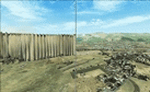
| Hinkley Point Power Station. ORBX recommended |
|
Images related to this file:
File Description:
For ORBX scenery.
Not tested with photo scenery.
Hinkley Point power station with access roads, small smoke, vehicles and vegitation and some building work next door!
Perfectly satisfying rendition of Hinkley Point for Flightsim purposes.
| Filename: | Hinkley_Point_Power_Station_ORBX_recommended.zip |
| License: | Freeware |
| Added: | 26th January 2017, 19:55:49 |
| Downloads: | 253 |
| Author: | John Watts |
| Size: | 990.75 KB |
| Category: Flight Simulator X - Scenery | |
| RAF Bradwell Bay |
|
File Description:
RAF Bradwell Bay is a former Royal Air Force station located 9.5 miles (15.3 km) east of Maldon, Essex, England and 3.1 miles (5.0 km) south west of West Mersea, Essex.
The airfield was first used as grass landing strip for the nearby firing ranges before being turned into a RAF station with concrete runways and hangars.The station is unique as it was the only fighter station where the Fog Investigation and Dispersal Operation (FIDO) was used.
Part of the site is currently being used by the Bradwell nuclear power station. Several of the hangars are still used as storage by the local farmers and the control tower is now a private house. Agricultural buildings, built in the '70s and '80s on runways one and two, are now home to several local businesses.
If you would like a more detailed history follow the following link. http://www.worldwar2heritage.com/en/page/9069/189/Bradwell-Bay-Airfield
| Filename: | RAF_Bradwell_Bay.zip |
| License: | Freeware |
| Added: | 26th January 2017, 20:05:03 |
| Downloads: | 138 |
| Author: | Terry Boissel |
| Size: | 18.06 MB |
| Category: Flight Simulator X - Scenery | |
| RAF Barford St John |
|
File Description:
RAF Barford St John is a Royal Air Force station just north of the village of Barford St. John, Oxfordshire, England. It is now a non-flying facility, operated by the United States Air Force as a communications centre with many large communications aerials, and is a satellite of RAF Croughton.
Source: Wikipedia
| Filename: | RAF_Barford_St_John.zip |
| License: | Freeware |
| Added: | 31st January 2017, 16:57:19 |
| Downloads: | 132 |
| Author: | Terry Boissel |
| Size: | 19.31 MB |
| Category: Flight Simulator X - Scenery | |
| St-Laurence Whales pack v2 |
|
Images related to this file:
File Description:
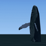
This collection includes seven species of whales encountered in Quebec: white-winged dolphins, belugas, killer whales, minke whales, humpback whales, fin whales and blue whales. To allow you to better appreciate the relative size of each species, a real holographic 3D whale show of this scene is present at each suggested departure airport. It is contained in the expoBaleine file.
| Filename: | StLaurence_Whales_pack_v2.zip |
| License: | Freeware |
| Added: | 1st February 2017, 19:18:56 |
| Downloads: | 321 |
| Author: | Jean-Pierre Fillion |
| Size: | 4.66 MB |
| Category: Flight Simulator X - Scenery | |
| RAF Keevil |
|
File Description:
The airfield was built on a site previously ear-marked for the purpose in the mid-1930s. Consisting of 3 long concrete
runways the airfield was used by the Royal Air Force and the United States Army Air Forces Eighth and Ninth Air
Forces.
In 1942 Keevil airfield was provided to the USAAF and it was assigned USAAF designation 471 (KV). Squadrons based at
the unit transported military freight and supplies using C-47 and C-53 aircraft.
RAF Fighter Command use
Short Stirlings of Nos. 196 and 299 Squadrons RAF lining the runway at RAF Keevil on the evening of 5 June 1944 before
emplaning paratroops of the 5th Parachute Brigade Group for the invasion of Normandy With the departure of the
Americans, the RAF used Keevil beginning in March 1944 for 196 and 299 Squadron Short Stirling glider tugs of No. 38
Group RAF arrived followed by a large number of Horsa gliders, crewed by Army pilots of the Glider Pilot Regiment.
The RAF Stirling aircraft were crewed by RAF, RCAF, RAAF, RNZAF and SAAF personnel and were engaged in SOE and SAS
drops. largely in France, and in glider towing. Their involvement in the Normandy invasion of France and Operation
Market-Garden is well remembered by Keevil and Steeple Ashton villagers. Casualties of army and air force personnel
were heavy and a number of aircraft were lost.
With the end of military control, Keevil airfield is virtually complete with all of its runways, perimeter track and
many of the hardstands still in place. It is used occasionally for British Army and RAF exercises. The airfield is
still frequently used by the RAF for training purposes such as air drops and parachuting, the gate is always locked
and access is restricted to authorized key holders only. Ref ~ http://www.wdrcfc.org.uk/wp/about-2/clubrules/
Since 1992 it has been home to the Bannerdown Gliding Club, an RAF Gliding and Soaring Association Club, affiliated to
RAF Brize Norton since the closure of nearby RAF station at Lyneham. The airfield is also used as a motorsport circuit
for various events. It is also the home of the Warminster and District Radio Control flying club.
In September 1994 the Keevil Society, organised by Paul Vingoe, held a Commemorative Day to mark the 50th anniversary
of the D-Day and Arnhem operations and to dedicate a memorial to all who served at Keevil, especially those who flew
from there and lost their lives.
Source:Wikipedia
| Filename: | RAF_Keevil.zip |
| License: | Freeware |
| Added: | 5th February 2017, 19:55:43 |
| Downloads: | 174 |
| Author: | Terry Boissel |
| Size: | 24.39 KB |
| Category: Flight Simulator X - Scenery | |
| RNAS Henstridge (HMS Dipper) |
|
File Description:
Royal Naval Air Station Henstridge or RNAS Henstridge (HMS Dipper) is a former Fleet Air Arm base located 7 miles (11 km) west of Shaftesbury, Dorset (Now Somerset) and 12.4 miles (20.0 km) east of Yeovil, Somerset in South West England.
The main part of the land (355 acres) was purchased in August 1941, after which building of the airfield and the marsh lane accommodation site commenced, it was commissioned on April 1, 1943 as HMS Dipper, principally as number 2 naval fighter school, on the 11th September 1942, another 18 acres was acquired at the adjoining gibbs marsh area for an aircraft repair and maintenance site. The design and lay-out of the airfield was quite unique, having 5 runways, 2 of these being east west lay-out (07-25) both 1000 yards long, the northern runway incorporated a dummy deck landing strip, complete with under-ground arresting gear with four above ground arrestor wires, which was a duplicate of that installed on HMS Implacable for training of aircraft carrier landings, these mainly being carried out with the Seafire, a naval version of the spitfire with folding wings. The site also had its own cinema and stage hall
March 1952 the airfield became inactive and was placed under care and maintenance, during 1953 Air whaling (now Bristow group) used the facilities for repairs to the whaling fleet of helicopters until moving out in June 1958.June 1957 it was finally closed as a naval establishment, from 1958-1960 the entire site was sold off. 27 June 1980 the BBC purchased the whole site and applied for planning permission to erect at the airfield a shortwave radio station consisting of 21 self-supporting towers holding aerial arrays and ancillary buildings on a 300-acre site. The station would transmit overseas radio services to Eastern Europe, the Soviet Union and perhaps South America the application failed and the BBC sold the land during January 1987 The airfield is also the home of the wessex strut, a general aviation club formed in January 1977, which holds an annual fly in and other events their first fly-in was on 17 April 1977 and attracted 107 aircraft. As of today the only usable runway is the north 07-25 runway, extant with the concrete dummy deck, and the underground machinery chamber, it is also the home to a large number of light aviation enthusiasts aircraft as well as the Yakolevs aerobatic display team and the Dorset and Somerset air ambulance
The current airfield is operated by EGHS and is an unlicensed airfield. The only usable runway is 07/25 tarmac/concrete 750 mts long x 6 mtr wide. Henstridge radio can be contacted on 130.250 MHz, it can be found at the south eastern stub of the Yeovilton MATZ
Source:Wikipedia
| Filename: | RNAS_Henstridge_HMS_Dipper.zip |
| License: | Freeware |
| Added: | 9th February 2017, 22:14:54 |
| Downloads: | 164 |
| Author: | Terry Boissel |
| Size: | 4.53 MB |
| Category: Flight Simulator X - Scenery | |
| Flattening Patch for FSX Tarija (SLTJ), Bolivia When Used with FreeMeshX |
|
Images related to this file:
File Description:
That is a flattening patch for the airport of Tarija (SLTJ), Bolivia when using FreeMeshX terrain by NineTwo Production, a freeware global terrain mesh for FSX. Comes with a French readme too. Freeware
| Filename: | Flattening_Patch_for_FSX_Tarija_SLTJ_Bolivia_When_.zip |
| License: | Freeware |
| Added: | 18th January 2017, 17:11:39 |
| Downloads: | 225 |
| Author: | G. Guichard |
| Size: | 125.39 KB |
© 2001-2026 AVSIM Online
All Rights Reserved
Privacy Policy |