
Where Flight Simulation Enthusiasts Gather from Around the World!
AVSIM Library - Search Results

| Category: Flight Simulator X - Scenery | |
| Pichlingersee - LOW1 |

|
Images related to this file:
File Description:
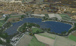
The Pichlingersee (LOW1) is a quarry pond near Linz (LOWL) in Austria (Upperaustria). The ILS approach to the runway 27 cross this lake. The helipad is in possession of Water Rescue Department and was not build on land. It was build "in water".
For the implementation of this area about 500 objects were set by hand from myself. Including not only trees and shrubs, but also signs, park benches, emergency call boxes (gernerated in gmax) etc at there right place. At night it was dark in real, so I does not create night texture. The scenery has 1.5 km ground imagery at 20cm per pixel and vary (hope) with the seasons.
Der Pichlingersee ist ein Baggersee in der Nhe von Linz (LOWL) in sterreich (Obersterreich). Der ILS Anflug auf die Landebahn 27 fhrt genau ber diesen See. Die Hubschrauberplattform gehrt der dortigen Wasserrettung und wurde nicht auf dem Land, sondern in den See hinein gebaut.
Fr die Umsetzung des Areals wurden von mir ber 500 Objekte von Hand gesetzt. Darunter nicht nur Bume und Strucher, sondern ebenso Schilder, Parkbnke, Notrufsulen (in gmax generiert) usw. an ihrem richtigen Platz. Da es dort in der Realitt nachts stockdunkel ist, habe ich auf Nachttexturen verzichtet. Die Szenerie hat eine 1.5 km Bodentextur mit 20cm/px und wechselt (hoffentlich) mit den Jahreszeiten.
| Filename: | Pichlingersee__LOW1.zip |
| License: | Freeware |
| Added: | 9th January 2013, 00:44:19 |
| Downloads: | 1,997 |
| Author: | Oliver Brandl |
| Size: | 54.71 MB |
| Category: Flight Simulator X - Scenery | |
| NY9 - Helms Aero Service - Long Lake, NY |
|
Images related to this file:
File Description:

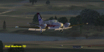
By request, here is an improved version of Helms Aero Service, Long Lake, NY. There was nothing at all there in FSX except a water runway. I moved the runway, added docks, static float planes, buildings, trees, park benches, telephone poles, and a marina. I also placed an Adirondack fire tower in the approximate location where a tower actually exists on Owl's Head. You'll have to search for it.
Due to the shore lines and roads involved in this scenery ULTIMATE TERRAIN X USA IS REQUIRED. Results will not be satisfactory without it.
| Filename: | NY9__Helms_Aero_Service__Long_Lake_NY.zip |
| License: | Freeware |
| Added: | 17th October 2010, 02:49:32 |
| Downloads: | 548 |
| Author: | Jim Cook |
| Size: | 3.54 KB |
| Category: Flight Simulator X - Scenery | |
| PN40 - (Moorhead Airpark - Home of the Erie Skydivers) |
|
File Description:
This is an improvement of what came with the default scenery in FSX for PN40. I have removed the dafault hangar and added two custom hangars using photo textures that are on the airport. The third hangar is one that comes with FSX. Added the peas that the skydivers use as a target when they jump. Replaced the default boundary and roads in the area surrounding the airport. Added the woods that are around the airort using SbuilderX. Also added the split rail fence using SbuilderX.
| Filename: | PN40__Moorhead_Airpark__Home_of_the_Erie_Skydivers.zip |
| License: | Freeware |
| Added: | 21st October 2007, 23:53:58 |
| Downloads: | 513 |
| Author: | Bill Good |
| Size: | 497.29 KB |
| Category: Flight Simulator X - Scenery | |
| KMDS, Madison SD Municipal Airport |
|
Images related to this file:
File Description:
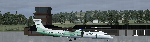
KMDS, Madison SD Municipal Airport
For FSX users only and as accurate
as possible with objects available.
Added lighting to grass runway and
improved lighting overall plus
buildings, people, flea market,
vehicles. Also added ATIS.
jimmy R martin
| Filename: | KMDS_Madison_SD_Municipal_Airport.zip |
| License: | Freeware |
| Added: | 14th June 2010, 01:24:33 |
| Downloads: | 549 |
| Author: | jimmy R martin |
| Size: | 1.39 MB |
| Category: Flight Simulator X - Scenery | |
| Roros Airport (ENRO) in Roros, Norway |
|
Images related to this file:
File Description:
Roros Airport (IATA: RRS, ICAO: ENRO; Norwegian: Roros lufthavn) is a regional airport located 2 kilometers (1.2 mi) from the town of Roros, Norway. The asphalt runway has the physical dimensions 1,740 by 40 meters (5,710 by 130 ft) and is aligned 14/32. Scheduled services are provided to Oslo by Wideroe. The main general aviation user is Rørosfly, a pilot school, and the aviation club Roros Flyklubb. (Source of information: Wikipedia August 20, 2016)
| Filename: | Roros_Airport_ENRO_in_Roros_Norway.zip |
| License: | Freeware |
| Added: | 20th August 2016, 15:40:59 |
| Downloads: | 680 |
| Author: | Hans Christian Knudsen and Knudsenair Simulations |
| Size: | 121.82 KB |
| Category: Flight Simulator X - Scenery | |
| KGDB - Granite Falls Municipal Airport/Lenzen-Roe-Fagen Memorial Field, Granite Falls, Minnesota, USA |
|
Images related to this file:
File Description:

A "Better Than Default" FSX scenery for the Granite Falls Municipal Airport/Lenzen-Roe-Fagen Memorial Field, Granite Falls, Minnesota, USA. See the README.txt file for details.
| Filename: | KGDB__Granite_Falls_Municipal_AirportLenzenRoeFage.zip |
| License: | Freeware, limited distribution |
| Added: | 12th June 2020, 17:08:41 |
| Downloads: | 198 |
| Author: | David Vega |
| Size: | 525.21 KB |
| Category: Flight Simulator X - Scenery | |
| Montmagny, Quebec Airport (CSE5) and airports of The Montmagny archipelago |
|
Images related to this file:
File Description:
Montmagny archipelago is a group of 21 islands located in the St. Lawrence River, between the northeastern tip of the Isle d'Orleans and the city of L'Islet.
Only the Isle-aux-Grues and Grosse-Ile are available to the public, other islands
are private.
This scenery include CSE5 airport, CSE5 hangar and terminal, CSH2 (Ile-aux-Grues) airport, CSH2 hangar and terminal, static planes, private strips, two AI ships moving in this area and many default FSX objects populating islands.
| Filename: | Montmagny_Quebec_Airport_CSE5_and_airports_of_The_.zip |
| License: | Freeware, limited distribution |
| Added: | 3rd November 2011, 16:21:22 |
| Downloads: | 1,925 |
| Author: | Pierre Gallant, Jean-Pierre Fillion |
| Size: | 4.53 MB |
| Category: Flight Simulator X - Scenery | |
| CSD3 Valleyfield, Quebec, Canada |
|
File Description:
This is the scenery CSD3( Valleyfield ) which represents the reality. Valleyfield is a town located on South bank of the St-Laurent river 30 miles west of Montreal, Quebec, Canada. This scenery is design with FSDS and it accepts Mesh of Gilles Gauthier.This scenery has the function for FS-2004 or FS-X.
| Filename: | CSD3_Valleyfield_Quebec_Canada.zip |
| License: | Freeware |
| Added: | 5th December 2009, 04:16:04 |
| Downloads: | 2,852 |
| Author: | Gerald Allaire |
| Size: | 1.73 MB |
| Category: Flight Simulator X - Scenery | |
| KSEA 2008 |
|
File Description:
This scenery adds the new 16R/34L runway and their ILS approaches, the associated taxiways, and flattens/excludes autogen from the new layout. Also includes updated AI/GPS approaches for all runways, and small updates to existing taxiways.
| Filename: | KSEA_2008.zip |
| License: | Freeware |
| Added: | 20th November 2008, 08:13:56 |
| Downloads: | 3,515 |
| Author: | Owen Catherwood |
| Size: | 2.71 MB |
| Category: Flight Simulator X - Scenery | |
| LJLJ - Jozef Puchnik International Airport - Ljubljana, Slovenia |
|
Images related to this file:
File Description:
Decent representation of Slovenian airport named after Jozef Pucnik,
located near the village Spodnji Brnik, some 15 miles north of Slovenia's capital Ljubljana.
The scenery is packed with many features: custom landclass in the walley underlying the approach paths to both runways(12 and 30),
custom airport layout as found after last reconstruction of aprons and taxiways, corrected approaches (so IFR AI traffic in case of a missed approach to runway 30 is no longer turning right crashing into the 8000ft mountains just North of the airport). All airport buildings are placed into their correct
locations and shapes, even if only default generic buildings and library objects were used.
You will also notice airport has 3 runways(AFCAD on steroids),when there is actually
only one in reality and only one is also visible in the simulation.
This was done in order to enable different categories of AI aircraft using different intersections
for departure and the only way possible to recreate this was to use overlayed runways of different lenght.
There are also some surprises hidden in the scenery, but we will leave them for you to discover.
Music titles used in the scenery are published with kind permission of the author, Mr.Slavko Avsenik.
Released as freeware but with limited distribution.
LJLJ2012 by SST - Slovenia Scenery Team
| Filename: | LJLJ__Jozef_Puchnik_International_Airport__Ljublja.zip |
| License: | Freeware, limited distribution |
| Added: | 10th June 2012, 15:30:05 |
| Downloads: | 3,464 |
| Author: | SST - Slovenia Scenery Team |
| Size: | 11.35 MB |
© 2001-2026 AVSIM Online
All Rights Reserved
Privacy Policy |