
Where Flight Simulation Enthusiasts Gather from Around the World!
AVSIM Library - Search Results

| Category: Flight Simulator 2004 - Scenery | |
| Arviat CYEK in Nunavut, Canada |

|
Images related to this file:
File Description:
Arviat is a small town on the west coast of Hudson Bay in Nunavut, around 90 miles south of Whale Cove, 130 miles south of Rankin Inlet, and 160 miles north of Churchill. The airfield is just south of the town, and the 4,000 feet of gravel runway is aligned 149T/329T; these are true bearings and not magnetic as Arviat is just inside the Northern Domestic Airspace zone. There is 100LL fuel available in drums, with 2 hours prior notice. The visiting AI airline is Calm Air, plus a cargo delivery by Buffalo Air. As a town of 2,200 people is too large to model I have used a landclass with autogeneration. The result includes some trees, which is not realistic, but there was no way out. There is a special note in the instructions regarding Flight Ontario replacement textures and "glowing" gravel aprons.
| Filename: | Arviat_CYEK_in_Nunavut_Canada.zip |
| License: | Freeware, limited distribution |
| Added: | 6th January 2012, 16:13:45 |
| Downloads: | 506 |
| Author: | Roger Wensley |
| Size: | 2.19 MB |
| Category: Flight Simulator 2004 - Scenery | |
| Matheson Point CWMP in Nunavut, Canada |
|
Images related to this file:
File Description:
This was a DEW line I Station on the southeast shore of King William Island; the island is around 70 miles square and Gjoa Haven is also on the southeast corner, 20 miles to the south. The station was closed in 1963 and has now been totally dismantled and removed except for a fallen 300 feet communications tower. The runway is still there (mostly) and is around 3,360 feet of gravel 120' wide, aligned 146T/326T. There are no lights, signage, or windsock, or any building remaining. All of these DEW line stations are not particularly impressive or even interesting. However, you can bet that any pilot flying regularly in the north along the coast knows where all these runways are, in case one of them suddenly becomes his favourite in the whole world just after the sudden silence.
| Filename: | Matheson_Point_CWMP_in_Nunavut_Canada.zip |
| License: | Freeware, limited distribution |
| Added: | 22nd November 2012, 16:28:19 |
| Downloads: | 178 |
| Author: | Roger Wensley |
| Size: | 785.57 KB |
| Category: Flight Simulator 2004 - Scenery | |
| CYUX - Hall Beach - Nunavut, Canada |
|
Images related to this file:
File Description:
This is the Fox-Main DEW line station that I somehow omitted to include when I posted Hall Beach. It is all those large radar things in the background in the screen shot.
Just install it like any scenery, just below HallBeachCYUX in the FS9 library priority.
| Filename: | CYUX__Hall_Beach__Nunavut_Canada.zip |
| License: | Freeware, limited distribution |
| Added: | 11th May 2014, 13:44:09 |
| Downloads: | 222 |
| Author: | Roger Wensley |
| Size: | 864.63 KB |
| Category: Flight Simulator 2004 - Scenery | |
| Kugaaruk CYBB and DEW Pelly Bay CWPB in Nunavut, Canada |
|
Images related to this file:
File Description:
Kugaaruk is on the coast of northern mainland Canada on the Boothia Peninsula, 60 miles into a deep north-south fjord-like inlet called Pelly Bay. The name was changed from Pelly Bay in 1999, and the population is around 800. Gjoa Haven is 150 miles to the west, and Hall Beach just over 200 miles to the east. Six miles south of the village, and connected by a gravel road, there is a NWS station and what remains of a DEW Auxiliary Site; the DEW site was closed in 1992, a year after the NWS station became operational. There is also a 3,350 feet long gravel runway beside Barrow Lake 2 miles east of the site, Pelly Bay CWPB. Kugaaruk airfield is adjacent to the village and the 5,000 feet of 100 feet wide gravel runway is aligned 049T/229T where T stands for "true" as opposed to magnetic. There are flights by First Air and Canadian North and the AI includes a daily flight of each from Yellowknife via Gjoa Haven (as per real life) plus a cargo visit by Buffalo. Although the runway is long enough to accomodate a 737 it is not licensed for regular scheduled jet flights; the reason for this is that the approach lighting is "inadequate". Included here is a new .bgl for Gjoa Haven which will remove the small hold short line from the gravel; my mistake.
| Filename: | Kugaaruk_CYBB_and_DEW_Pelly_Bay_CWPB_in_Nunavut_Ca.zip |
| License: | Freeware, limited distribution |
| Added: | 25th November 2012, 00:43:07 |
| Downloads: | 427 |
| Author: | Roger Wensley |
| Size: | 6.1 MB |
| Category: Flight Simulator 2004 - Scenery | |
| Qikiqtarjuaq CYVM (Broughton) and DEW FOX-5 in Nunavut, Canada |
|
Images related to this file:
File Description:
Qikiqtarjuaq is an airfield on the northeast coast of Baffin Island, just over 100 miles north of Pangnirtung. The airfield is the closest Canadian airfield to Greenland and is used for ferry flights from Canada to Europe for small planes, though there is normally only JetA1 fuel available. The airfield is at only 18 feet ASL next to the sea with the village to the north; it was previously (before 1998) called Broughton Island. The runway is 3,800' of 100' wide gravel and is lighted; as it is in the Northern Domestic Airspace the runway is signed as 033T-213T, using "true" bearings instead of magnetic. There is a terminal and a small maintenance building on the apron and these have been modeled specifically for this scenery. There are AI parking spots; the AI visiting aircraft are a Canadian North Dash 8 and a First Air 42-300. Qikiqtarjuaq village is just north of the airfield and has a population of around 520; it is approximately the right size and shape but no buildings were specifically modeled for the village. There is also a North Warning System site called Fox-5 to the northeast, and this too is included. You will need Ultimate Terrain Alaska Canada.
| Filename: | Qikiqtarjuaq_CYVM_Broughton_and_DEW_FOX5_in_Nunavu.zip |
| License: | Freeware, limited distribution |
| Added: | 14th June 2011, 02:04:26 |
| Downloads: | 555 |
| Author: | Roger Wensley |
| Size: | 1.85 MB |
| Category: Flight Simulator 2004 - Scenery | |
| SAE-1, First Soviet Antarctic Expedition |
|
Images related to this file:
File Description:
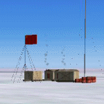
FS2004 Scenery - the First Soviet Antarctic expedition. This scenery represents three permanent Antarctic stations established by the First Soviet Antarctic expedition (Mirny, Pionerskaya, Oasis). By Alexander Belov
| Filename: | SAE1_First_Soviet_Antarctic_Expedition.zip |
| License: | Freeware, limited distribution |
| Added: | 2nd June 2010, 13:46:42 |
| Downloads: | 1,244 |
| Author: | Alexander Belov |
| Size: | 3.85 MB |
| Category: Flight Simulator 2004 - Scenery | |
| LTBQ - Cengiz Topel Naval Air Station Scenery |
|
Images related to this file:
File Description:
LTBQ - Cengiz Topel Naval Air Station Scenery created with ADE9 v.1.79 and static objects libraries with using the latest satellite images available from Google Earth.
| Filename: | LTBQ__Cengiz_Topel_Naval_Air_Station_Scenery.zip |
| License: | Freeware |
| Added: | 27th May 2023, 00:48:20 |
| Downloads: | 231 |
| Author: | Taner Akol |
| Size: | 8.57 MB |
| Category: Flight Simulator 2004 - Scenery | |
| Sanikiluaq CYSK in Hudson Bay, Nunavut, Canada |
|
Images related to this file:
File Description:
Sanikiluaq is a village 740 or so inhabitants at N56 30, W79, which means in the southern part of Hudson Bay, close to James Bay. The village is at the north end of Flaherty Island, which is the largest of the Belcher Islands. You might fly there from La Grande Riviere in Quebec (200 miles SSE) or maybe from Moosonee in Ontario at the bottom of James Bay (350 miles SSW). Sanikiluaq village does not feature in FS9, so the first thing to do was to add it; it is the right shape and with around the right number of houses on the right streets but as I wasn't going to model 100+ individual houses just think of it as a hand-made auto-generated village. I also had to move the airfield over beside the river, so there is a DELETE file and a GRASS file and a ROADS file, as well as an AFCAD for AI and a scenery file. And AI for a visiting Air Inuit plane.
| Filename: | Sanikiluaq_CYSK_in_Hudson_Bay_Nunavut_Canada.zip |
| License: | Freeware, limited distribution |
| Added: | 11th October 2010, 23:15:41 |
| Downloads: | 515 |
| Author: | Roger Wensley |
| Size: | 2.21 MB |
| Category: Flight Simulator 2004 - Scenery | |
| EDON - Wriezen-Neuhardenberg - Berlin, Germany |
|
Images related to this file:
File Description:
Wriezen-Neuhardenberg Airfield (EDON Marxfelde), the former airfield of Deutsche Demokratische Republik (DDR) Airline Interflug. The airfield is located 55 km east of Berlin. There are actual no scheduled flights to Wriezen-Neuhardenberg, so the airfield management decided to take part on alternative energy systems and installed the world biggest solar-powerplant on its apron.
| Filename: | EDON__WriezenNeuhardenberg__Berlin_Germany.zip |
| License: | Freeware |
| Added: | 27th July 2014, 02:48:18 |
| Downloads: | 402 |
| Author: | David Kolas |
| Size: | 1.93 MB |
| Category: Flight Simulator 2004 - Scenery | |
| Rangsdorf Airfield |
|
Images related to this file:
File Description:
Rangsdorf Airfield, the place where Graf Schenk von Stauffenberg once enter a aircraft to kill the fuehrer of the third reich adolf hitler. It was closed in 1990. In former times it was used by the soviet army as helicopter base. In the beginning, it was the homebase of buecker flugzeugwerke till world war II. The airfield is located ca. 2 miles south of Berlin-Schoenefeld Airport which will soon be Berlin-Brandenburg International.
| Filename: | Rangsdorf_Airfield.zip |
| License: | Freeware |
| Added: | 19th July 2014, 17:24:03 |
| Downloads: | 403 |
| Author: | David Kolas |
| Size: | 10.24 MB |
© 2001-2026 AVSIM Online
All Rights Reserved
Privacy Policy |