
Where Flight Simulation Enthusiasts Gather from Around the World!
AVSIM Library - Search Results

| Category: Flight Simulator 2004 - Scenery | |
| Homer PaHO in Alaska US |

|
Images related to this file:
File Description:
Homer is a mainly GA airfield with rows of open air parking, but it also has scheduled flights, a terminal building, a long (for GA) runway of just under 6,700 feet that is 150 feet wide and aligned 03-21 with VASI on both ends and ILS on 03. So I think we can refer to it as an airport. Plus, at the time of this scenery (around 2010) there were three newly completed hangars on the north apron that I was told were for three companies, Bald Mountain Air service, Maritime Helicopters, and Pathfinder Aviation. I do not know which was for whom, but all three companies are in the helicopter and/or plane charter business. The south apron has a number of hangars and other buildings along it's length, starting at the western end with Smokey Bay Air that has an old control tower on the roof, then the Fire Station, and then Homer Air. I am not aware of who owns what after those first three, except that at the far eastern end there are several garages etc for the airport maintenance equipment. Next to the airport at that end there are a number of boat maintenance companies with boats pulled out of the water; this could not be well replicated due to the airport elevation above the sea level and a misplaced road. The nearby Beluga Lake 5BL float base is also included here, with some AI. The lake height above sea level has been adjusted to cope with too many cliffs intruding into the water; this is an annoying FS9 habit. The Homer scenery is as close to the actual airport as I could make it, while coping with inaccurate coast lines and roads, and grassed areas that could not all be modified for reasons that I will not bore you with. The Spit is a major scenery feature next to the airport, and I have added to this to provide some boats, docks, and nearby buildings etc. Small planes use the adjacent gravel taxi path instead of the runway when back-tracking to take off on runway 21. They only go as far as the path takes them and then u-turn onto the runway and take off. By the way, this airport's AI will function at its best if the prevailing wind makes 03 the runway in use. And I will eventually stop writing 03 and just call it 3, as the US, alone in the world, does not put a zero in front of 01, 02, 03, 04 etc. Just one other thing to note is that all access to the runway is from taxiways A and B; there was (in 2010) no access to the extreme western end of the runway as the taxiway there is marked as out of service pending a needed resurfacing.
If you find an error email me please, and note that my email address has been changed to rogwens at Gmail dot com.
| Filename: | Homer_PaHO_in_Alaska_US.zip |
| License: | Freeware, limited distribution |
| Added: | 28th July 2021, 03:31:04 |
| Downloads: | 131 |
| Author: | Roger Wensley |
| Size: | 11.86 MB |
| Category: Flight Simulator 2004 - Scenery | |
| Homer PaHO in Alaska US missing parked planes |
|
Images related to this file:
File Description:
These are the parked planes and their textures that I forgot to include in the Homer PAHO scenery post. Apologies.
| Filename: | Homer_PaHO_in_Alaska_US_missing_parked_planes.zip |
| License: | Freeware, limited distribution |
| Added: | 28th July 2021, 17:02:11 |
| Downloads: | 56 |
| Author: | Roger Wensley |
| Size: | 3.45 MB |
| Category: Flight Simulator 2004 - Scenery | |
| Homer PaHO in Alaska US missing parked planes |
|
Images related to this file:
File Description:
These are the parked planes and their textures that I forgot to include in the Homer PAHO scenery post. Apologies.
| Filename: | Homer_PaHO_in_Alaska_US_missing_parked_planes.zip |
| License: | Freeware, limited distribution |
| Added: | 28th July 2021, 17:02:25 |
| Downloads: | 99 |
| Author: | Roger Wensley |
| Size: | 3.45 MB |
| Category: Flight Simulator 2004 - Scenery | |
| Ketchikan Int airport ( PAKT ) version 2 |
|
File Description:
This is version 2 of my scenery for PAKT in Alaska. As well as fixing a bug in version one, it also has an updated building for aero services Fbo, an added fire station and some more objects added. It remains both default and Misty compatable.
| Filename: | Ketchikan_Int_airport__PAKT__version_2.zip |
| License: | Freeware |
| Added: | 13th May 2006, 02:34:54 |
| Downloads: | 6,703 |
| Author: | Alan Wright |
| Size: | 6.5 MB |
| Category: Flight Simulator 2004 - Scenery | |
| Ketchikan PAKT in southern Alaska plus float planes 5KE and the town |
|
Images related to this file:
File Description:
This is Ketchikan PAKT in southern Alaska, 45 miles north of the Canadian border and 220 miles south of Juneau. It is the closest major Alaskan airport to the lower 48 and most flights from or to Seattle pass through Ketchikan en route. The airport is on the southern side of the stretch of water known as The Narrows and the town is on the northern side, with ferries connecting the two. The town side was somewhat modified as part of one of the three Misty Fjords sceneries, so there were already some marinas and docked cruise liners etc before I started this. In addition, Ketchikan Airport had been partly made way back in 2006, and further modified in 2007; I say "partly" as there is in fact no way to accurately make PAKT within the limitations of FS9 as there is a 50 or 60 feet difference in elevation between runway and apron, and the taxiways are actually ramps up from the apron to the ends of the runway. This has a knock-on effect on the float plane and ferry docks on the water below the airport. I can see why the Misty Fjord sceneries avoided it. This scenery retains the original buildings from the Alan Wright scenery. It also includes the modification made by John Hinson, who created the second taxiway to the western end of the runway; FS9 had not included this as the original airport started operations with only one taxiway in place. There are new vehicles on the apron (fuel etc), new apron markings and some parking modifications to enable AI with Boing 737, DC6, Beechcraft 1900, and GA, plus runway and taxiway signage, windsocks, some car parking, freight items, etc. There is a road and covered bridges down to the docks and ferry, and the town side of the water has been modelled to include other float plane docks along with waterfront buildings, including the ship repair facility with it's dry dock (actually a floating dock that lifts ships out of the water) and the Alaskan Ferry Terminal wharf etc. The ferry forms a part of the AI, generously permitted by FSAddon and originally a part of the payware Tongass Fjords package, as are the AI aircraft also included here. There are new waterside buildings that stretch from the ship repair yard, past the shopping plaza and onward to the stationary cruise liners (that were part of the Tongass payware scenery) including float docks for the float plane companies that are based in Ketchikan, plus a new AI liner. The AI is a further adaptation of the already posted CF36 AI and PAKN AI, as listed in the AI folder. Due to the surrounding hills there may be some interference with AI float aircraft, depending on the wind direction, though I have watched succesful Beaver landings with the wind from the east. The combined AI for float planes creates a float plane take off or landing at, on average, 20 minute intervals; this is still well short of the actual busy summertime period.
| Filename: | Ketchikan_PAKT_in_southern_Alaska_plus_float_plane.zip |
| License: | Freeware, limited distribution |
| Added: | 12th February 2017, 23:27:59 |
| Downloads: | 1,239 |
| Author: | Roger Wensley |
| Size: | 47.11 MB |
| Category: Flight Simulator 2004 - Scenery | |
| Juanda Surabaya Indonesia (WRSJ) |
|
File Description:
Located at East Java of Indonesia, second busiest airport in Indonesia still using photoreal textures and animation. Gmax scenery with low fps and AFCAD includes, moving vehicles and an activedocking system. Please support us to visit www.iscenery.net
| Filename: | Juanda_Surabaya_Indonesia_WRSJ.zip |
| License: | Freeware |
| Added: | 3rd March 2006, 02:52:01 |
| Downloads: | 12,435 |
| Author: | Budi Santoso |
| Size: | 4.86 MB |
| Category: Flight Simulator 2004 - Scenery | |
| LFQX Laon-Couvron AB 1955-62 |
|
Images related to this file:
File Description:
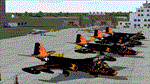
From 1950 to 1967 the USAF set up and maintained bases in France, with the agreement of the French government, as part of its commitment to the North Atlantic Treaty Organisation. Laon AB was one of the ten main air bases which supported both attack and air defence capabilities. Many people do not appreciate the sheer extent of the USAF bases in France at this time and the reasons leading to the USAF departure in 1967. There is a link to a fine article on all this included.
This is the second in a series of USAFE bases in France, the first being LFJA Chaumont AB. This scenery and traffic represent Laon Air Base during the years 1955 to 1962. Custom Tower and Hangars by Dan French with Custom aircraft paints by Ken Lawson and DeltaDart. Traffic files and the aircraft and paints needed are provided for 1955 (including the Black Knights B-57 Demonstration Team), 1957, 1959 and 1962.
| Filename: | LFQX_LaonCouvron_AB_195562.zip |
| License: | Freeware |
| Added: | 22nd November 2023, 16:08:03 |
| Downloads: | 90 |
| Author: | Al Von Pingel, Ken Lawson, Dan French |
| Size: | 35.77 MB |
| Category: Flight Simulator 2004 - Scenery | |
| Oceano County Airport (L52) |
|
File Description:
Oceano County Airport is a public airfield in the coastal city of Oceano, CA. Airport features custom objects, photoreal textures and AI traffic file. Created by Dustin Mosher.
| Filename: | Oceano_County_Airport_L52.zip |
| License: | Freeware, limited distribution |
| Added: | 1st January 2009, 12:46:31 |
| Downloads: | 957 |
| Author: | Dustin Mosher |
| Size: | 9.36 MB |
| Category: Flight Simulator 2004 - Scenery | |
| Soekarno-Hatta Intl Airport, Jakarta Update |
|
File Description:
Update for SOEKARNO-HATTA Scenery for Microsoft FS2004. With AES support.
- this scenery update is FREEWARE
- Buddy is not responsible, in any way, for any problems and
damages occurring from the use or misuse of this scenery (please backup first ur old scenery)
- add palm trees and triangle near gate
- banana trees around airport near fence
- remove default building on gate D (fixed)
| Filename: | SoekarnoHatta_Intl_Airport_Jakarta_Update.zip |
| License: | Freeware, limited distribution |
| Added: | 20th March 2008, 12:45:35 |
| Downloads: | 12,412 |
| Author: | Budi Santoso |
| Size: | 227.55 KB |
| Category: Flight Simulator 2004 - Scenery | |
| Lajes AB, Azores Portugal |
|
Images related to this file:
File Description:
FS2004 scenery for the Lajes Airbase/Airport located in the Azores. Custom scenery and AI included. Scenery is a fully functional stand alone package but can benefit from addtional downloads (see readme in package). Special thanks to Jake Burrus for his P-3 aircraft and Graham King for his eye-popping repaints.
| Filename: | Lajes_AB_Azores_Portugal.zip |
| License: | Freeware, limited distribution |
| Added: | 20th December 2010, 08:43:25 |
| Downloads: | 5,706 |
| Author: | John Stinstrom |
| Size: | 8.1 MB |


© 2001-2026 AVSIM Online
All Rights Reserved
Privacy Policy |