
Where Flight Simulation Enthusiasts Gather from Around the World!
AVSIM Library - Search Results

| Category: Flight Simulator 2004 - Scenery | |
| Chicoutimi / St-Honore CYRC in Quebec Canada |

|
Images related to this file:
File Description:
This is the third of five sceneries around Lac Saint-Jean in Quebec, Canada. Saint-Honore is a village on a crossroads 32 miles east of the lake, and the airport, called Chicoutimi in the Nav Canada Flight Supplement, is a mile or so east of the village. It is of the familiar triangular military design with three runways 12-30, 06-24, and 18-36. Of these, the longest is 12-30 at over 6,000 feet and has approach lighting and glide slope indicators. Of the other two 06-24 is now closed, but this scenery is based on the 2010 situation with all three open. There are two apron areas, one just to the south of 12-30 and a second to the northwest of 06-24 and served by a separate taxiway. The largest operator is a training establishment based on the northern apron and with a sizeable fleet of Beechcraft trainers (Skipper) that does not exist as an FS9 plane, so these are represented by a similar stand-in substitute. There is also a helicopter emergency evacuation operation to the east of the large control tower, and other hangars. The south apron has two main companies, Max Aviation and Exact Air, both of which run local regular scheduled flights in the area (though both appear to have now subcontracted these out to other companies) and also engage in training and charter flights. There is also a parachute training company. The ai includes flights by the companies on the field and also GA. The list of AI planes is explained in the AI folder, with details of downloads etc. The fleet of training aircraft is one of the planes in the revised (by Nick Tselepides) Piper Aircraft, designed for AI Traffic by Andras Neumann with a Paintkit by Charles Dayhuff adapted by Graham Eccleston, and Paints by Graham Eccleston, Andras Neuman and Frank Cooper along with the trainer repaint by Nick Tselepides. The Max and Exact aircraft textures are approximations by me; apologies. The use of the runways also as taxiways complicates the AI on runway 12-30 as directed by ATC. The AI will always leave 12-30 by the earliest exit, which means that the fleet of trainers will exit to the southern apron but will then taxi back onto the runway to reach taxiway A or runway 36 (according to wind direction) to proceed to the northern apron. In real life they land long and then taxi straight to the end of the runway to reach taxiway A or runway 36 without using the south apron at all. There is no way to correct this so just be ready to go around.
| Filename: | Chicoutimi__StHonore_CYRC_in_Quebec_Canada.zip |
| License: | Freeware, limited distribution |
| Added: | 12th November 2017, 17:35:21 |
| Downloads: | 346 |
| Author: | Roger Wensley |
| Size: | 29.03 MB |
| Category: Flight Simulator 2004 - Scenery | |
| CYHU Airport's Ambiance |
|
File Description:
CYHU airport: buildings & statics for FS-2002 & 4, really.
Hello, Flight 200# Simmers ! Here is a very rough
representation of what CYHU looks like.
The kit is made of 2 separate files:
CYHUBLD.ZIP = the buildings, and
CYHPLANE.ZIP = ambiance, with static vehicules.
I made 2 files, for those with slower machines.
! 2002 & 2004 Tested ! The 2 SCENES INSTALLED !
My "machine" = Pentium III, 1000 mhz. 384 megs RAM.
Video= nVIDIA Vanta 32mgs, AGP. So, YOU should be
able to run the FULL kit too !
*** See photos in CYHUBLD.ZIP ***
| Filename: | CYHU_Airports_Ambiance.zip |
| License: | Freeware |
| Added: | 12th August 2004, 22:54:34 |
| Downloads: | 3,787 |
| Author: | Jean Morissette |
| Size: | 1.25 MB |
| Category: Flight Simulator 2004 - Scenery | |
| Alma CYTF in Quebec Canada |
|
Images related to this file:
File Description:
This is the second of five sceneries around Lac Saint-Jean in Quebec, Canada. Alma, the town, is 7 miles east of Lac Saint-Jean, on both the northern and southern banks of the Saguenay River. The airfield is at the southern edge of the town, with a single 13-31 runway 5,000 feet long and approach lighting at both ends. There is a visible ILS sytem but this was no longer in operation by 2010, the approximate date setting of this scenery. The largest operation on the field, by far, is Panorama Helicopters (actually Helicopteres Panorama) and this is reflected in the AI and a parked static helicopter. The ai includes helicopters that were originally posted as part of the payware Alaska Fjords series, with the permission of FSAddon. There are also other planes listed that will be required here or for the future posts in this series and are included here. The amphibious Beaver AI plane will only be available if you already have the payware Aerosoft Beaver installed, and I should have made it clear that the float Beaver included in the CTD3 AI was also an Aerosoft plane.
| Filename: | Alma_CYTF_in_Quebec_Canada.zip |
| License: | Freeware, limited distribution |
| Added: | 6th November 2017, 19:30:34 |
| Downloads: | 230 |
| Author: | Roger Wensley |
| Size: | 17.42 MB |
| Category: Flight Simulator 2004 - Scenery | |
| Maniwaki CYMW in Ontario Canada |
|
Images related to this file:
File Description:
Maniwaki airfield is seven miles south of the town of Maniwaki and some 60 miles north of Ottawa, up the Gatineau River. There is a generous 5,000 feet of runway 03/21 that is 150 feet wide and in bad condition, so bad that there are now almost no markings of any sort (even a centre line, the apron has more paint than the runway!) and the whole lot is going to be redone next summer. The apron is large, and in the summer accomodates two Bombardier CL 415 fire fighting amphibians, which is why there is a large access platform loitering on the apron. There are only five hangars on the field with another one tucked into the trees behind a house. The hangars and the office/cafe building have been modelled specifically for this field. There are further buildings to the north which are not actually on the airfield and which house fire department personnel.
| Filename: | Maniwaki_CYMW_in_Ontario_Canada.zip |
| License: | Freeware, limited distribution |
| Added: | 14th February 2010, 23:12:27 |
| Downloads: | 509 |
| Author: | Roger Wensley |
| Size: | 4.56 MB |
| Category: Flight Simulator 2004 - Scenery | |
| Photoreal landclass of Bayonne Anglet Biarritz |
|
File Description:
This landclass increases visual of the French Basque coast, mainly the city of Bayonne Anglet Biarritz. This landclass has the four seasons textures as well as the night texture. Realized on original textures of (C) ORTHOLITTORALE 2000. v1.1
| Filename: | Photoreal_landclass_of_Bayonne_Anglet_Biarritz.zip |
| License: | Freeware, limited distribution |
| Added: | 13th September 2005, 14:00:08 |
| Downloads: | 5,874 |
| Author: | Julien Scavini |
| Size: | 12.66 MB |
| Category: Flight Simulator 2004 - Scenery | |
| Algiers City PhotoTerrain Scenery |
|
Images related to this file:
File Description:
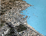
FS2004 Algiers City PhotoTerrain Scenery by Riad GHENIM
Algiers DAAG, Algeria, Mediterannean city.
This phototerrain scenery works with Algiers Real Scenery for FS2004 v1.01
| Filename: | Algiers_City_PhotoTerrain_Scenery.zip |
| License: | Freeware |
| Added: | 3rd June 2011, 22:23:16 |
| Downloads: | 5,957 |
| Author: | Riad Ghenim |
| Size: | 23.88 MB |
| Category: Flight Simulator 2004 - Scenery | |
| North Shore Airfield, NZNE. ( to fit into "RealNZ Auckland City" Photoreal ) |
|
File Description:
Welcome to North Shore, a busy general aviation airfield situated in the Dairy Flat area of northern Auckland , New Zealand. North Shore is among New Zealands busiest GA airfields, and is home to a number of aviation companies such as North Shore Helicopers, and Great Barrier Air also have a base there. This scenery is designed to fit into the "RealNZ Auckland City" photoreal scenery (payware by Robin Corn).
Requires some EZ Scenery object sets (see INSTALL instructions for details).
| Filename: | North_Shore_Airfield_NZNE__to_fit_into_RealNZ_Auck.zip |
| License: | Freeware, limited distribution |
| Added: | 19th April 2008, 10:19:28 |
| Downloads: | 1,063 |
| Author: | Lawrie Roache / Charl Du Toit |
| Size: | 2.28 MB |
| Category: Flight Simulator 2004 - Scenery | |
| Galena PAKP in Alaska |
|
Images related to this file:
File Description:
Galena is a village on the Yukon River, around 30 miles east of the corner where the westward running river turns south. The population is just under 500 and the city is noted for its educational facilities that attract residential students from across the state. Adjacent to the city is the Galena Air Force Station that previously shared the use of the Edward G. Pitna Snr. airport until 2007, when the station was closed and the air force personnel left. The station facilities have been taken over by the community and the airport became the largest state-maintained airport in the interior of Alaska. Substantial resurfacing and finishing work was then carried out, and the new asphalt runway is now 6,000 feet long and aligned 7-25, with VASI at both ends and ILS on 25. There is a secondary gravel runway beside part of the main asphalt runway, and this is treated in radio announcements as if it is not a separate runway and landing or take off are on the adjacent asphalt. The airport is serviced by ERA (now called Ravn) and Wrights Air, with cargo flights by the eternal Everts. Included here is a small modification for Allakaket, which deletes a single remaining stock FS9 taxiway light. The AI included here also provided Allakaket with a Saturday Everts delivery flight, but I neglected to mention that before. A note here about my scenery making. There will not be many more to follow this as I am almost at the end of the photos I either took or found for scenery purposes, plus I expect to move on from FS9 at some point during next year.
| Filename: | Galena_PAKP_in_Alaska.zip |
| License: | Freeware, limited distribution |
| Added: | 27th November 2019, 19:14:00 |
| Downloads: | 262 |
| Author: | Roger Wensley |
| Size: | 13.95 MB |
| Category: Flight Simulator 2004 - Scenery | |
| El Formosa - Taiwan Scenery Project, Part 12 - Taipei City |
|
Images related to this file:
File Description:
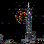
Taipei City is the national capital and the largest metropolitan area of Taiwan. With population more than 2.6 millions, Taipei City is also the hub of political, economic, and cultural center of Taiwan. This scenery el Formosa - Taiwan Scenery Project, Part 12 presents several landmarks for joyful sightseeing flight over Taipei City. Require el Formosa - Taiwan Scenery Part1, Part3, Part4, Part6, Part 7, and Part8 for correct river/coastline matching.
| Filename: | El_Formosa__Taiwan_Scenery_Project_Part_12__Taipei.zip |
| License: | Freeware, limited distribution |
| Added: | 30th November 2011, 02:20:24 |
| Downloads: | 4,669 |
| Author: | Rudolf Liu, Formosa Group |
| Size: | 8.58 MB |
| Category: Flight Simulator 2004 - Scenery | |
| FS9 Fort St John CYXJ in BC Canada |
|
File Description:
Fort St John is close to the border between British Columbia and Alberta, around 40 miles north-northwest of Dawson Creek. The airport was originally a Royal Canadian Air Force base, associated with the wartime construction of the Alaska Highway. The airfield was part of this construction effort and the wartime ferrying of planes to Russia. It is currently named "North Peace Regional Airport", or "North Peace Airport"; apparently there has been no final decision?
The date for this scenery is around 2006. I was given an old video tape cassette which was filmed on an uncertain date, but which had to be before the terminal building was renovated in 2007 and totally changed in appearance. The only way to view the video was to play it in the camera and watch it on a small screen. After I had completed everything except the buildings I started to view the video to establish the building appearances and within an hour or so the camera died. It was so old there was no way to repair it, so I then made some new buildings from memory of the video and what was available online. I also used some that I had already made for other scenery but which were similar. I may replace the terminal building that is in this version with a build of the new one, as I know this one is not a very accurate reproduction. The replacement, if I do it, will be towards the end of this year.
The AI included here is for GA, Air Canada Jazz, and two helicopter companies that were (and still are?) based there. One is at the western end of the apron and the other is at the eastern end but separated from the apron. To gain access to the taxiways and runways (so that all airport users follow the same procedures, for safety reasons) the eastern end helicopters just taxi across the grass. The helicopters are used for maintenance trips to the oil and gas fields in the surrounding area. My screenshots show Westjet at the terminal; this is because I have later Canadian AI installed, while the AI included here is only for the time around 2000 to 2010, when Westjet were not flying to Fort St John.
The airport is square in plan, with the apron running along the northern side and two runways forming diagonals. The two runways are 11-29 (6,882 feet long and 200 feet wide, with ILS at the 29 end and PAPI at the other) and 02-20 (6,684 feet long and 200 feet wide, and with PAPI at each end). The eastern side taxiway that runs north-south is not used. The western side taxiway is in use but only as a race track for cars.
Please email me if you find faults, such as a plane without textures.
| Filename: | FS9_Fort_St_John_CYXJ_in_BC_Canada.zip |
| License: | Freeware, limited distribution |
| Added: | 10th October 2022, 14:03:38 |
| Downloads: | 216 |
| Author: | Roger Wensley |
| Size: | 37.49 MB |


© 2001-2026 AVSIM Online
All Rights Reserved
Privacy Policy |