
Where Flight Simulation Enthusiasts Gather from Around the World!
AVSIM Library - Search Results

| Category: Flight Simulator 2004 - Scenery | |
| Mackenzie CYZY in British Columbia, Canada |

|
Images related to this file:
File Description:
Mackenzie is around 120 miles west of Peace River and the BC/Alberta border, at the southern end of Williston Lake. The lake is 135 miles long and the population of the town is about 3,500; those figures illustrate typical Canada, a huge area enjoyed by the few. The main occupations relate to timber and mining in some form, plus tourism (in particular winter sports tourism). The airport is 2 miles southwest of the town, with no regular scheduled flights but it is not unusual to find Central Mountain Air there delivering either charter passengers or freight. The single runway is aligned 16-34 and 100 feet wide lit asphalt that is just over 5,000 feet long, with (in 2010 or so) an additional 1,500 feet of gravel. There is PAPI at both ends of the asphalt. The largest operation based at the airfield is a helicopter company, at the northern end of the apron. There is a "mandatory frequency" of 123.5 which is a Canadian invention; you MUST have a radio. There is no control tower at the actual airfield, and if or when there is no response from further afield then you announce your intentions etc. In FS9 there is no way to "switch off or on" the monitoring of a MF radio frequency so you will find that this one is always silent.
| Filename: | Mackenzie_CYZY_in_British_Columbia_Canada.zip |
| License: | Freeware, limited distribution |
| Added: | 27th December 2018, 20:19:05 |
| Downloads: | 131 |
| Author: | Roger Wensley |
| Size: | 19.81 MB |
| Category: Flight Simulator 2004 - Scenery | |
| Culebra Scenery Fix |
|
File Description:
Thos is a fix for my recent scenery of Culebra PR , to correct the trees on the runway.(those airport workers didnt cut the trees) please delete the file before pasting these one. sorry for the inconvenience...roberto
| Filename: | Culebra_Scenery_Fix.zip |
| License: | Freeware |
| Added: | 24th July 2004, 05:45:14 |
| Downloads: | 1,153 |
| Author: | Roberto Ayala "rotol" |
| Size: | 165.8 KB |
| Category: Flight Simulator 2004 - Scenery | |
| Mountain View CPZ3 in Ontario, Canada |
|
Images related to this file:
File Description:
This is Mountain View, a small RCAF airfield at the eastern end of Lake Ontario on Prince Edward Island, some 40 miles west of Kingston. Mountain View is used for training during the summer months, and part of this training is for C-130 crews, who practice landing on rough or unprepared landing strips. The crews are based at Trenton, which is a large base 10 miles to the northwest on the mainland. There are (or were, I haven't seen it recently) numerous parked and ancient fighter planes such T-33's and Canadair Tutors; these could also have possibly been used for summer training or perhaps were just stored. Last summer there were only two hangars left standing; in 2002 there were five. In real life you would be on the lookout not only for C-130's but also (at certain times during the summer) for parachutists and also gliders. This airfield is one that you will fly over and not land on; I confess that I have cheated with the length of the 06L-24R gravel "practice" runway, so that it became possible for the FS version of a touch-n-go with a C-130 to be completed without using the grass. The aerial photograph shows the new "practice" gravel runway under construction.
| Filename: | Mountain_View_CPZ3_in_Ontario_Canada.zip |
| License: | Freeware, limited distribution |
| Added: | 9th March 2012, 15:05:57 |
| Downloads: | 350 |
| Author: | Roger Wensley |
| Size: | 7.26 MB |
| Category: Flight Simulator 2004 - Scenery | |
| Buffalo Narrows CYVT in Saskatchewan, Canada |
|
Images related to this file:
File Description:
Buffalo Narrows is a small town (around 1,400 folks) 130 miles west and a bit north of La Ronge in Saskatchewan, and I discovered that the Buffalo Narrows airfield, wrongly positioned in FS9, had been flooded out by Ultimate Terrain's lake; this is the rescue package. Actually that would be several lakes as the place is surrounded by water including Churchill Lake, Little Peter Pond Lake, and of course Big Peter Pond Lake.
There are two runways, the longest being 5,006' of 100' wide asphalt aligned 11/29, and the other 2,297 and 75' wide, also asphalt. Both runways are lit, and there is JetA and 100LL fuel available. I have placed taxiway lights, but I haven't made proper signage or placed runway lights, or a ton of other things, but it is now landable and with the buildings and fire chemical retarder tanks etc, and there is AI that includes a CL-415. The roads have also been modified to fit.
| Filename: | Buffalo_Narrows_CYVT_in_Saskatchewan_Canada.zip |
| License: | Freeware, limited distribution |
| Added: | 15th July 2012, 19:31:20 |
| Downloads: | 499 |
| Author: | Roger Wensley |
| Size: | 1.8 MB |
| Category: Flight Simulator 2004 - Scenery | |
| Dervio scenery - Como lake Italy |
|
Images related to this file:
File Description:
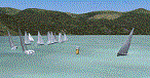
Scenery homage to a beautifull little town in north of Como lake of Italy; builded-up mainly with some existing objects and some buildings sintax made. It DOES NOT INCLUDE any airport, but represents only some pictures of Dervio town, reachable from Como Idroscalo floating airport or Samolaco or Sondrio Caiolo airports (closest ones); this is one of the moorings of Navigazione del Lago di Como. Informations: Dervio is one of the beautiful towns on north east area of Como lake, on a handland created by Varrone river. North and closed to the town, you can find Corenno Plinio old castle and in the opposite side of the lake the S. Bernardo church; you can also have some fireworks, obviously suggested with the night. Contents:
Mooring pier at snack bar, with awning and tables; Ferryboat in the lake with some sailbots in race between two buoys; Walk alongside the shore of the lake, with benches and some fisher piers; Main church with related church house and footbal soil; Several buildings, parking area, factories, bar and restaurant with tables chairs and gazebos, gas station and cars; Rail station with a small train and road gates; Sailbots on ground inside Centro Vela Dervio area and slipway with dinghy; Little marina with boats; Public park with entering gate, covered stand and tables; Residence La Boldona bloks with buildings, swimmin pool and tennis facilities, fenced; Campsite with campers, roulottes and tents; Corenno Plinio castle with tower and S. Bernardo little church; Spread of trees in all the scenery; (night scenery)two floating platforms wiht fireworks; six wood bonfires on shore of lake and on the mountains; One big ship with some other sailboats and speedboats
| Filename: | Dervio_scenery__Como_lake_Italy.zip |
| License: | Freeware |
| Added: | 22nd February 2011, 22:59:46 |
| Downloads: | 949 |
| Author: | Aldo Della Vedova |
| Size: | 12.71 MB |
| Category: Flight Simulator 2004 - Scenery | |
| Wakefield riverfront in Quebec Canada |
|
Images related to this file:
File Description:
The village of Wakefield is 18 miles northwest of Ottawa on the west shore of the Gatineau River, and I seem to have been flying north up that river from Rock cliffe for years, past the village in a bend of the river just a few miles north of Cascades float base. It is where the tourist steam train goes through, and by "through" I mean that literally as the tracks are at the side of the main street, and one of the things it goes past is the Black Sheep Inn which hosts Canadian musical groups and individuals at the weekends. Though the radio in Ottawa uses the name in English it is actually and visibly called "Mouton Noir" on the sign. There is no airfield, and no float base. There aren't even all the buildings that are on the riverfront as it stretches further south and north. There is a public dock where you can tie up. Apart from the fact that the idea caught my fancy one afternoon outside the Mouton Noir I really can't think why I made this.
| Filename: | Wakefield_riverfront_in_Quebec_Canada.zip |
| License: | Freeware, limited distribution |
| Added: | 1st May 2010, 00:39:24 |
| Downloads: | 406 |
| Author: | Roger Wensley |
| Size: | 11.23 MB |
| Category: Flight Simulator 2004 - Scenery | |
| Suisse 2004 Fricktal-Schupfart LSZI |
|
File Description:
Totally exclusive scenery, never published as freeware till now. Fricktal-Schupfart is a small airfield North of Switzerland, between Basel and Zurich, in the Jura. It has a short grass runway. South of LSZI there is the Atomic Plant of Goesgen. Very detailled scenery with smoke effect, seasonal change (people, textures,...), animated landing T. Also works perfectly with FS2002.
| Filename: | Suisse_2004_FricktalSchupfart_LSZI.zip |
| License: | Freeware, limited distribution |
| Added: | 5th October 2003, 17:01:30 |
| Downloads: | 8,079 |
| Author: | Daniel Gauthier |
| Size: | 4.06 MB |
| Category: Flight Simulator 2004 - Scenery | |
| Suisse 2004 Bad Ragaz LSZE |
|
File Description:
Last Suisse 2002 update for FS2004 and FS2002. Bad Ragaz is far East of Switzerland and has a very narrow runway and a special approach over a moutain with a restaurant. Be careful. Two files are included depending on which mesh you're using. Read the readme doc please.
| Filename: | Suisse_2004_Bad_Ragaz_LSZE.zip |
| License: | Freeware, limited distribution |
| Added: | 19th October 2003, 17:33:03 |
| Downloads: | 9,316 |
| Author: | Daniel Gauthier |
| Size: | 2.4 MB |
| Category: Flight Simulator 2004 - Scenery | |
| Suisse 2004 Biel-Kappelen LSZP |
|
File Description:
Biel-Kappelen is a small airfield West of Switzerland not far from Bern with a grass runway. Update scenery with new photoreal textures, animated landing T, but better frame rates. Works with FS2002 too.
| Filename: | Suisse_2004_BielKappelen_LSZP.zip |
| License: | Freeware, limited distribution |
| Added: | 5th October 2003, 17:05:08 |
| Downloads: | 7,329 |
| Author: | Daniel Gauthier |
| Size: | 2.39 MB |
| Category: Flight Simulator 2004 - Scenery | |
| Yverdon-les-Bains LSGY Suisse 2004 |
|
File Description:
Yverdon is a small airfield West of Switzerland. Updated file to work with FS2004, but is always a FS2002 scenery. New animation (landing T) and better frame rate.
| Filename: | YverdonlesBains_LSGY_Suisse_2004.zip |
| License: | Freeware, limited distribution |
| Added: | 2nd October 2003, 15:26:23 |
| Downloads: | 7,830 |
| Author: | Daniel Gauthier |
| Size: | 3.65 MB |
© 2001-2026 AVSIM Online
All Rights Reserved
Privacy Policy |