
Where Flight Simulation Enthusiasts Gather from Around the World!
AVSIM Library - Search Results

| Category: Flight Simulator 2004 - Scenery | |
| MESH 2010 SurAmerica - Brasil 4 |

|
Images related to this file:
File Description:
MESH FERMANDOIS 2010 V1.0 / Brasil / index(BR7, BR8) / A highly detailed 30m SRTM mesh for South America (FS2004 and FSX)
| Filename: | MESH_2010_SurAmerica__Brasil_4.zip |
| License: | Freeware |
| Added: | 2nd December 2009, 18:07:08 |
| Downloads: | 1,811 |
| Author: | Jose Fermandois |
| Size: | 82.29 MB |
| Category: Flight Simulator 2004 - Scenery | |
| MESH 2010 SurAmerica - Brasil 5 |
|
Images related to this file:
File Description:
MESH FERMANDOIS 2010 V1.0 / Brasil / index(BR9, BR10) / A highly detailed 30m SRTM mesh for South America (FS2004 and FSX)
| Filename: | MESH_2010_SurAmerica__Brasil_5.zip |
| License: | Freeware |
| Added: | 2nd December 2009, 18:07:46 |
| Downloads: | 1,759 |
| Author: | Jose Fermandois |
| Size: | 83.93 MB |
| Category: Flight Simulator 2004 - Scenery | |
| "Trump and Palazzo" Las Vegas, NV |
|
Images related to this file:
File Description:

"Trump and Palazzo" Las Vegas, Nevada. DSDG is proud to present "Trump and Palazzo" scenery. This scenery is intended for FS2004, and adds the Trump and Palazzo hotels in Las Vegas, NV. By Andrea Bertolucci. dsdg.webs.com
| Filename: | Trump_and_Palazzo_Las_Vegas_NV.zip |
| License: | Freeware |
| Added: | 7th December 2009, 10:27:06 |
| Downloads: | 2,278 |
| Author: | DSDG, Andrea Bertolucci |
| Size: | 3.89 MB |
| Category: Flight Simulator 2004 - Scenery | |
| Correctif_projet_Abitibi_2 |
|
File Description:
A scenery file was missing in Abitbi project_2 and Lac des Baies coordinates were wrong. English and french instructions in the read_me files.
| Filename: | Correctif_projet_Abitibi_2.zip |
| License: | Freeware |
| Added: | 20th December 2009, 17:01:03 |
| Downloads: | 99 |
| Author: | Pierre Fauteux |
| Size: | 26.46 KB |
| Category: Flight Simulator 2004 - Scenery | |
| Europe SRTM mesh part 05: Poland |
|
File Description:
Europe SRTM LOD9 mesh part 5 of 13: Covers all parts of Poland north of 50'N. This Europe SRTM project was optimized for the lowest HDD space use: Each part matching exactly the boundaries of its neighbors, you'll have a complete coverage of Europe without gap or overlapping scenery.
Based on SRTM Data v1 and v2 (3 arcsec, 90m) and sampled to LOD9 resolution (90m). Each SRTM tile was carefully checked and repaired with Blackart v4.02: water areas are now flattened (lighter mesh), and SRTM voids were treated taking advantage of Blackart's sophisticated interpolation algorithm. When required, biggest voids were patched with oversampled SRTM 30 arcsec data and/or manual input.
| Filename: | Europe_SRTM_mesh_part_05_Poland.zip |
| License: | Freeware, limited distribution |
| Added: | 23rd December 2009, 10:34:50 |
| Downloads: | 17,169 |
| Author: | Yohann Baptiste |
| Size: | 35.01 MB |
| Category: Flight Simulator 2004 - Scenery | |
| Boulder (KBDU) / Longmont / Loveland, Colorado, Photo-Scenery (FS9 & FSX) |
|
Images related to this file:
File Description:

Boulder is situated where the Rocky Mountains meet the Great Plains. Just west of the city are imposing slabs of sedimentary stone tilted up on the foothills, known as Flatirons. Located at the base of the foothills is Boulder's main campus of the University of Colarado which is clearly visible from the sky. Longmont is home of the Denver ARTCC (Air Route Traffic Control Center) which controls all flights in the upper airspace of most of Colorado and parts of adjoining states. To explore the scenery depart from Boulder (KBDU) and head northeast. Extends my Rocky Mountain Park scenery to the east and my Denver scenery to the north. Provides another 3.500 sq km in 4.7m/pix quality. High resolution versions for FS9 and FSX (much sharper, but larger and multiple downloads) are available at www.blueskyscenery.com/GNB_East.html . The screenies are taken from the high-res versions, so expect this version to be slightly more blurry. YourDonation@Work: Dedicated to Senges and Eric.
| Filename: | Boulder_KBDU__Longmont__Loveland_Colorado_PhotoSce.zip |
| License: | Freeware, limited distribution |
| Added: | 28th December 2009, 20:14:09 |
| Downloads: | 2,388 |
| Author: | Gottfried Razek - blueskyscenery.com |
| Size: | 94.26 MB |
| Category: Flight Simulator 2004 - Scenery | |
| Las Vegas (KLAS), Nevada, Photo Scenery (FSX too) |
|
Images related to this file:
File Description:

This package contains photo-scenery for the greater area of Las Vegas, covering an area of 3.250 sq km and is dedicated to the donators Donald, John and David. The scenery reaches from the foothills of Mt. Charleston to Lake Mead (partly covered). The quality is in standard FS2004-resolution of 4.7m/pixel. It works equally well in FS2004 and FSX. Hi-Res overlays fill follow. For a complete list of available titles please visit us at www.blueskyscenery.com
| Filename: | Las_Vegas_KLAS_Nevada_Photo_Scenery_FSX_too.zip |
| License: | Freeware, limited distribution |
| Added: | 30th December 2009, 18:01:52 |
| Downloads: | 10,855 |
| Author: | Gottfried Razek - blueskyscenery.com |
| Size: | 80.59 MB |
| Category: Flight Simulator 2004 - Scenery | |
| Longue-Pointe de Mingan CYLP, Quebec, Canada |
|
Images related to this file:
File Description:
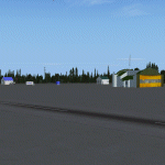
This scenery represents real the airport of Longue-Pointe of Mingan (CYLP). I carried out this scenery with FSDS. Longue-Pointe of Mingan is localised on northern bank of the St-Laurent river in Quebec, Canada. This scenery is built for both FS-2004 and FS-X.
| Filename: | LonguePointe_de_Mingan_CYLP_Quebec_Canada.zip |
| License: | Freeware |
| Added: | 30th December 2009, 21:28:47 |
| Downloads: | 899 |
| Author: | Regis Dassylva |
| Size: | 9.69 MB |
| Category: Flight Simulator 2004 - Scenery | |
| Natashquan CYNA , Quebec, Canada |
|
Images related to this file:
File Description:
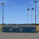
This scenery represents as much as possible the airport of Natashquan (CYNA). However, certain frontages of the buildings can farier, not having had the authorization to take photographs on the ground. This scene was built with FSDS and it is compatible for FS-X and FS-2004. Natashquan is located at Quebec, Canada on banks of the St-Laurent river. It is a small village of the Cote-Nord.
| Filename: | Natashquan_CYNA__Quebec_Canada.zip |
| License: | Freeware |
| Added: | 30th December 2009, 21:33:27 |
| Downloads: | 1,137 |
| Author: | Regis Dassylva |
| Size: | 7.6 MB |
| Category: Flight Simulator 2004 - Scenery | |
| Canyonlands National Park South, Monticello (U43), Utah, Photo-Scenery (FSX too) |
|
Images related to this file:
File Description:
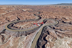
This scenery covers the southern part of Canyonlands National Park (Needles District) in Utah. The colorful layers of sand- and limestone that you can see today built over hundreds of millions years by advancing and retreating oceans as well as rivers that deposited huge amounts of sediment. About 15 million years ago these layers began to rise due to a colliding movement of plates in the earth's crust, forming what is today called the Colorado Plateau. As the land rose higher, erosion accelerated, resulting in countless canyons, mesas and buttes. The uplifting land caused the rivers to carve in even faster, resulting in the deep canyons of the Colorado and Green Rivers. The needles and fins in the Needles District have yet another story: First uplifts and later slides created a system of perpendicular cracks. Then he resulting crosshatched pattern of "joints" widened by erosion until only thin fins and needles of rock remained. The scenery extends my Arches National Park scenery to the south and brings you another 3.500 sq km in 4.7m/pix quality. To explore the scenery depart from Monticello (U43) and head north. YourDonation@Work: Dedicated to Nels, David and Michael. Thanks!
| Filename: | Canyonlands_National_Park_South_Monticello_U43_Uta.zip |
| License: | Freeware, limited distribution |
| Added: | 30th December 2009, 21:44:56 |
| Downloads: | 1,528 |
| Author: | Gottfried Razek - blueskyscenery.com |
| Size: | 95.76 MB |


© 2001-2026 AVSIM Online
All Rights Reserved
Privacy Policy |