
Where Flight Simulation Enthusiasts Gather from Around the World!
AVSIM Library - Search Results

| Category: Flight Simulator 2004 - Scenery | |
| VFR of Lario, Area A3 - Como lake, Italy |

|
Images related to this file:
File Description:
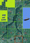
This scenery, 16th of the project, covers approximately an area of 7.5x6 kmt, from Corneno-Galliano-Carella-Mariaga (NW) to Valmadrera (NE), from Costa Masnaga (SW) to Colle Brianza, Nava (SE); specific buildings are included as overpasses of highway SS36 at inlet of Barro mountain and Cross at Cornizzolo mountain. Have nice flights on Como lake.
Check video available here: http://youtu.be/E4QB-HqlUt4
| Filename: | VFR_of_Lario_Area_A3__Como_lake_Italy.zip |
| License: | Freeware |
| Added: | 19th October 2013, 20:21:51 |
| Downloads: | 624 |
| Author: | Aldo Della Vedova, Daniele Lanfranchi, Gian Mario Verga |
| Size: | 12.47 MB |
| Category: Flight Simulator 2004 - Scenery | |
| LPBV - Benavente, Portugal |
|
File Description:
BENAVENTE AIRFIELD V1. This certificate aerodrome for ULM's has no published ICAO assigned, so for ease of flight simulation, I've gave it the fake LPBV and is to be used with freeware PTTerrain of PTSIM (http://www.ptsim.com); digital photos taken at the place that have been applied to buildings and other equipment.
Freeware for FS9. Not tested for FSX.
| Filename: | LPBV__Benavente_Portugal.zip |
| License: | Freeware |
| Added: | 24th October 2013, 19:04:43 |
| Downloads: | 404 |
| Author: | Joao A. Graca Ferreira |
| Size: | 10.92 MB |
| Category: Flight Simulator 2004 - Scenery | |
| TVSV - ET Joshua Airport |
|
Images related to this file:
File Description:
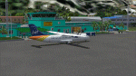
Airport of Saint-Vincent Island:"ET-Joshua (TVSV)".
(Version 2)
| Filename: | TVSV__ET_Joshua_Airport.zip |
| License: | Freeware |
| Added: | 28th October 2013, 08:40:57 |
| Downloads: | 1,117 |
| Author: | Delblond Christian |
| Size: | 6.37 MB |
| Category: Flight Simulator 2004 - Scenery | |
| Mattala Intl. Airport (VCRI), Sri Lanka |
|
Images related to this file:
File Description:
Sri Lankan Virtual Airlines (ALK-VA) has developed Sri Lanka's newest airport VCRI-Mattala Rajapaksa Intl. airport, Hambantota scenery for FS2004. All data is accurate as per the currently available airport information. Scenery files will be updated when new information is received. Please check ALK-VA website for the latest revision.
| Filename: | Mattala_Intl_Airport_VCRI_Sri_Lanka.zip |
| License: | Freeware |
| Added: | 30th October 2013, 21:01:00 |
| Downloads: | 413 |
| Author: | Imal Mille |
| Size: | 298.43 KB |
| Category: Flight Simulator 2004 - Scenery | |
| WIOD/WIKD - H.A.S. Hanandjoeddin Airport - Tanjung Pandan, Indonesia |
|
File Description:
H.A.S. Hanandjoeddin Airport or Buluh Tumbang Airport (IATA: TJQ, ICAO: WIOD, formerly WIKD) is an airport in Tanjung Pandan, Bangka-Belitung, Indonesia. It is the main airport serving Belitung Island.
| Filename: | WIODWIKD__HAS_Hanandjoeddin_Airport__Tanjung_Panda.zip |
| License: | Freeware |
| Added: | 31st October 2013, 14:09:26 |
| Downloads: | 698 |
| Author: | Billy Guo |
| Size: | 196.59 KB |
| Category: Flight Simulator 2004 - Scenery | |
| KMLB Melbourne International |
|
Images related to this file:
File Description:
Rwy12 objects (lights, jetways, and vehicles), and an AFCAD for Melbourne International Airport in Melbourne, FL. No custom buildings, but it's much improved from the default. Requires ESDG Ramp Lights and S. Ansari Jetways libraries.
| Filename: | KMLB_Melbourne_International.zip |
| License: | Freeware |
| Added: | 3rd November 2013, 22:24:21 |
| Downloads: | 544 |
| Author: | Dave Athay |
| Size: | 269.96 KB |
| Category: Flight Simulator 2004 - Scenery | |
| Fort Resolution CYFR in the Northwest Territories, Canada |
|
Images related to this file:
File Description:
Fort Resolution is on the south side of Great Slave Lake, 75 miles east of Hay River and just west of where the Slave River flows into the lake from Fort Smith. Fort Resolution, the oldest community in the Territories and once a vital link in the fur trade business, is a small town with a population of around 500. It was not included in the original FS9 or Ultimate Terrain so I have added it here.
The airfield is next to the town on the lakeshore. The runway is 4,000 feet of gravel with a displaced threshold at the southern (town) end; it is lit and there is PAPI. There are no scheduled flights to Fort Resolution, just occasional charters; the AI includes a stock FS9 Cessna and a Wasaya Airways PC12.
| Filename: | Fort_Resolution_CYFR_in_the_Northwest_Territories_.zip |
| License: | Freeware, limited distribution |
| Added: | 4th October 2013, 22:11:26 |
| Downloads: | 294 |
| Author: | Roger Wensley |
| Size: | 2.31 MB |
| Category: Flight Simulator 2004 - Scenery | |
| Albian CAL4, Firebag CFG6, Horizon CYNR, Mildred Lake CER4, and Muskeg Tower CFW4 in Alberta Canada |
|
Images related to this file:
File Description:
All of these airfields are in or close to the Athabasca Tar Sands in Alberta, modelled here along with the airfields. The tar sands workings extend along the Athabasca River for over 60 miles north of Fort McMurray in northern Alberta, and the huge cleared areas, surface mining, tailings ponds, and refineries along the Athabasca are right up there as Alberta's biggest VFR landmark. One look at a tailings pond (sea? ocean?) makes it clear that someone was worried about public reaction to the size. As well as the surface mining there are also large areas where there is underground extraction with a grid of dirt tracks between equipment installations. There are four airfields associated with the tar sands. Horizon CYNR is a public service airport operated by Canadian Natural Reources Ltd. Mildred Lake CER4 is owned and operated by Syncrude. Albian CAL4 is owned and operated by Shell Canada, and Firebag CFG6 is owned and operated by Suncor Energy. The fifth airfield is the nearby Muskeg Tower CFW4, which is there solely to support folks during their fire watch in the 120 feet tall tower. There is also a sixth airfield east of Horizon across the river and still visible, Bitumount; this is no longer in use. There is Ai included involving Canadian North, North Cariboo, Wasaya, HTS, First Air, Suncor, etc.
| Filename: | Albian_CAL4_Firebag_CFG6_Horizon_CYNR_Mildred_Lake.zip |
| License: | Freeware, limited distribution |
| Added: | 4th October 2013, 22:12:42 |
| Downloads: | 938 |
| Author: | Roger Wensley |
| Size: | 16.75 MB |
| Category: Flight Simulator 2004 - Scenery | |
| RAF Wittering 1990 |
|
Images related to this file:
File Description:

Wittering was opened as an RAF station in 1924, but flying here started way back in 1916 with the Royal Flying Corps.
Initially the Central Flying School was based here from 1926 until 1935. During World War 2, Wittering was a part of 12 Group, which was responsible for the defence of the Midlands.
The station took on a nuclear responsibility in 1956 with the arrival of the V-Force Valiants, and later Victor bombers. Because of this, the runway was increased in length.
After the V-Bombers left, the station took on the mantle of Home of the Harrier, a title it carried with it from 1969, until the stations closure in 2010.
This scenery is made up of various library objects, using ScruffyDuck's ADE9X, to make a close representation of the base, as opposed to being factually accurate.
Brian has incorporated most of the extra runways and representations of deck landing areas that were used at Wittering for V/STOL training - these runways are not active, but may still obviously be used for taking off and landing yourself.
Also included are repaints of John Young's Harrier GR3/T4 AI model, available from flightsim.com. These represent the aircraft of No.1(F) Squadron and No.233 OCU, during 1989-90.
There are also a set of representative flightplans to allow the Harriers to fly "typical" missions and flights.
| Filename: | RAF_Wittering_1990.zip |
| License: | Freeware, limited distribution |
| Added: | 6th October 2013, 17:17:42 |
| Downloads: | 1,392 |
| Author: | Brian Clarke, Daryl Payne |
| Size: | 20.58 MB |
| Category: Flight Simulator 2004 - Scenery | |
| ETUO - RAF Gutersloh AB |
|
Images related to this file:
File Description:
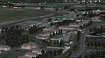
FS 2004 scenery - RAF Gutersloh AB (ICAO: ETUO)
The scenery represents the former airbase of RAF Gutersloh, one of the most populated military bases in West Germany during the Cold War, due to its location near the former East/West border. This scenery reflects the era at the end of the 1980s/beginning of the 90s, when the Harrier GR3 was in operation there, along with Chinook helicopters.
The airfield was built in 1935 and was used by the German Air Force during WW2, flying the Junkers JU-86 and Heinkel H-111. The first British squadrons were stationed there from 1947, with Mosquitos, Vampires and then Canberras.
The first Harrier arrived at Gutersloh in January 1977 and 3 and 4 Squadrons became resident until their farewell in 1993, after the cold war had ended. The airfield is currently used by the British army, but they will leave in 2014 to relinquish the area to the Government of Gutersloh for civil usage.
High detailed scenery by Manfred Schyma and Pete Beeby, supported by the Airfield Construction Group.
| Filename: | ETUO__RAF_Gutersloh_AB.zip |
| License: | Freeware |
| Added: | 10th October 2013, 20:30:01 |
| Downloads: | 1,925 |
| Author: | Manfred Schyma / Pete Beeby |
| Size: | 173.25 MB |


© 2001-2026 AVSIM Online
All Rights Reserved
Privacy Policy |