|
AVSIM Library - Search Results
|
|
Login | Register | About logging in and out
|
Searching for:
Author matching 'rick keller'
in AVSIM File Library and below.
|

|
|
|
|
|
|
Images related to this file:
|
File Description:
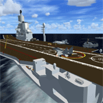
INS Vikramaditya was commisioned into the Soviet Navy as Baku in 1988. It is the third and final remaining Kiev class carrier, the other two being Admiral Kuznetsov and Lioning. Like Lioning, Vikramaditya was purchased from Russia but that is pretty much where the similarity ends. The Chinese quietly bought Varyag under the guise that it would be converted into another floating hotel or casino as had been done several times in the past; then, almost to everyones surprise, they re-built and announced they had an aircraft carrier. India contracted with Russia to complete the refit which began an epic saga of international proportions that encompassed espionage, honey traps and logarithmically expanding budgets. Originally promised for 2008, the latest quotes expect delivery in October/November 2013.
I think the carrier looks very sporty or yacht-like, with the ski-jump bow and the oversized island which has been criticized for being too far into the middle of the deck; it is said to be India's final non-indigenous warship and future flagship to serve for the next 20 to 30 years.
This model is intended for placement with AI Carriers, by Lamont Clark. It has animated radars, working cables, catapults and deck lights. The IFLOS is calibrated, but the catapults will only activate if the airplane deploys a launch bar. The Vikramaditya uses retractable chocks to allow aircraft to develop full thrust, but I could not find a way to lock an aircraft to represent the STOBAR configuration without using catapults. I did not define the elevators because they do not operate and are in the middle of the deck. There are two ships included for escort, the INS Talwar and a Russian Fregat II class ASW destroyer. They have hard decks and night lighting, animated radars, funnel smoke, etc.
|
| Filename: |
vikramaditya_314261_314261.zip |
| License: |
Freeware, limited distribution |
| Added: |
23rd August 2013, 21:43:41 |
| Downloads: |
965 |
| Author: |
Rick Keller |
| Size: |
19030kb |
|
|
Other files which are related to, or may be required by, this file:
Images related to this file:
File Description:
KHIO Hillsboro, home to Hillsboro Aviation, Aero Air, Global Aviation, the Oregon Classic Aircraft Aviation Museum, Premier Space Systems, the Oregon International Air Show and the Nike hangar. The scenery is extremely detailed and has a large photo ground .bgl (KHIO photo ground) that must be joined and added separately.
Part 1 of 3, the remaining 2 parts contain the .BGL file.
| Filename: |
khio_hillsboro.zip |
| License: |
Freeware, limited distribution |
| Added: |
20th September 2014, 19:56:41 |
| Downloads: |
1423 |
| Author: |
Rick Keller |
| Size: |
200680kb |
|
|
Other files which are related to, or may be required by, this file:
File Description:
Part 2 of the original scenery, this contains the first half of the .BGL file. The scenery package consists of 3 parts: Main scenery and the BGL which is divided into 2 parts of its own.
Part 1: Main scenery (khio_hillsboro.zip)
Part 2: BGL file part A (KHIO_bgl_a.zip)
Part 3: BGL file part B (KHIO_bgl_b.zip)
This is BGL Part A. Please follow the readme carefully and pay attention to the order of the files.
| Filename: |
khio_bgl_a.zip |
| License: |
Freeware, limited distribution |
| Added: |
23rd September 2014, 18:51:09 |
| Downloads: |
935 |
| Author: |
Rick Keller |
| Size: |
479561kb |
|
|
Other files which are related to, or may be required by, this file:
File Description:
Part 3 of the original scenery, this contains the first half of the .BGL file. The scenery consists of 3 parts: Main scenery and the BGL which is divided into 2 parts of its own.
Part 1: Main scenery
Part 2: BGL file part A
Part 3: BGL file part B
This is BGL Part B. Please follow the readme carefully and pay attention to the order of the files.
| Filename: |
khio_bgl_b.zip |
| License: |
Freeware, limited distribution |
| Added: |
24th September 2014, 12:33:10 |
| Downloads: |
901 |
| Author: |
Rick Keller |
| Size: |
481282kb |
|
|
Images related to this file:
|
File Description:
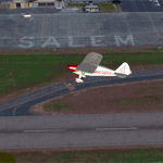
The original AFCAD was created by Kevin Burns, but the airport looked kind of barren in the surrounding coverage area; so I added 650 odd objects and seasonally adjusted photo ground textures to spruce it up a bit, then reworked all the aprons and taxiways to match the photo. Tools used were: Airport Design Editor 1.55, SBuilderX, ModelConverterX.
|
| Filename: |
ksle.zip |
| License: |
Freeware, limited distribution |
| Added: |
20th April 2013, 04:57:50 |
| Downloads: |
1423 |
| Author: |
Rick Keller |
| Size: |
179620kb |
|
|
Images related to this file:
File Description:
Situated at the gateway to the Columbia River Gorge and one of the bases for Hillsboro Aviation's largest helicopter school in the Pacific Northwest, Troutdale Airport regularly endures winds in excess of 50 mph during the winter easterlies.
This version was made with adjusted photographic ground imagery and a custom ground polygon runway. The airport has many custom objects; lights with attached effects, buildings, aircraft and vehicles. Airport Design Editor and ModelConverterX were instrumental in producing this add-on.
| Filename: |
kttd_troutdale_oregon.zip |
| License: |
Freeware, limited distribution |
| Added: |
30th March 2014, 14:14:17 |
| Downloads: |
1003 |
| Author: |
Rick Keller |
| Size: |
123646kb |
|
|
Images related to this file:
File Description:
Pearson Field, Vancouver Washington. This airport was originally created to accompany a large photo-scenery, which is the reason there are so many buildings that are placed accurately, but outside the area of the included photo ground. All of the buildings are straight renders from Google Earth or the Trimble Warehouse and Fort Vancouver, the Army Air Museum, the nearby mall with Fred Meyer and several other landmarks are included. The photo ground has 4 seasons and night and if the ground is a little gray, apologies, I kind of overdid it for hard winter. You can just change seasons for greener pastures.
| Filename: |
kvuo_pearson_field_vancouver,_wa.zip |
| License: |
Freeware, limited distribution |
| Added: |
1st February 2014, 00:02:10 |
| Downloads: |
859 |
| Author: |
Rick Keller |
| Size: |
87945kb |
|
|
Images related to this file:
|
File Description:
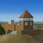
The museum and visitor center house a diorama of the parks ecosystems, complete with the sounds found in nature, and a topographic model of the mountain. On one wall, an instructional video and lighted display case describes the geologic forces that created the mountain. On anther wall, cultural history is chronicled with splendid photographs. The lower level of the summit building contains panels describing the Native American history of the region and an audio-visual room. Rotating displays of art and photography complement the permanent exhibits. In addition to the exhibits, there is a small gift center within the building.
Outside the summit building, telescopes are mounted on the observation deck. A close-up view of the Delta and the surrounding geology is just a quarter. On a clear day, the Sierra Nevada can be seen with the naked eye. If you look carefully, ancient marine fossils embedded in the sandstone walls can be seen along the stairway walls leading to the observation deck. The rotunda on top of the summit building is a reminder of Mount Diablo's importance as a survey point. Sitting atop the rotunda is the old navigation beacon, lighted once a year on December 7 in memory of Pearl Harbor.
http://www.mdia.org/site/park-information/park-info/summit-museum/2-information/21-summit-building.
Made with SketchUp, designed for ORBX FTXNCA Northern California using Prepar3d V3.2. The files are simple and will probably work with other versions of the simulator.
|
| Filename: |
mt_diablo_summit_museum.zip |
| License: |
Freeware, limited distribution |
| Added: |
13th June 2016, 20:46:13 |
| Downloads: |
183 |
| Author: |
Rick Keller |
| Size: |
1109kb |
|
|
Images related to this file:
File Description:
Four general aviation fields that I developed in collaboration with a scenery project. 1W1 Grove Field, 4S9 Mulino, S48 Country Squire and WA67 Green Mountain. Photo ground, adjusted "afcad" and added objects, enjoy!
| Filename: |
oregon_ga.zip |
| License: |
Freeware, limited distribution |
| Added: |
25th December 2013, 07:51:06 |
| Downloads: |
575 |
| Author: |
Rick Keller |
| Size: |
310194kb |
|
|
Images related to this file:
|
File Description:
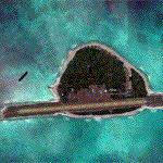
Pagasa Island is a jewel in the South China Sea. It is the one pictured - an emerald splash in an azure sea slashed by a coral runway - whenever new collisions or confrontations are reported in the news for the region. Occupied continuously by the Philippines since 1971, historical use dates back to the Han dynasty, which many believe forms the basis of the Chinese claim to the island. Each country has it's own interpretation of international law and the Filipinos are clearly banking on the precedence of continuous occupation, at no small expense, as Rancudo Field is the farthest airport from Manila within the Philippine sphere of control.
Surprisingly, the geography of the island serves to capture and retain rainwater, although the aquifer is stagnant and the water must be treated for consumption. Sea life remains abundant, poachers take coral heads and sea turtles. There is a solar farm and recently installed solar street lights, fuel for the generators is a precious commodity this far from the mainland.
Sadly, nature may solve the struggle for possession by withdrawing the island from the arena. It is believed that the construction of the runway may have compromised the islands basic integrity, allowing it to crumble into the sea. Whatever the cause, the evidence is clear. Bunkers built during the Japanese occupation in WWII are already slipping beneath the waves and the rate of salt water encroachment has been recorded at close to 6" per day.
There are some things to explore, the grounded BRP Laneo Del Norte to the west; over to the north near the resort grounds are a dugout fishing canoe and some authentic Philippine bangka boats; you may want to load up and head east to do some low warning passes over the Chinese fishing fleet. Standing at the east end of the field, you can just barely spot the China Coast Guard cutter's smoke on the horizon.
The tower is marked by a bright strobe that fires once every five seconds and at night it is bright enough to guide you back to the island from the distance of the fleet. There are no published procedures and the tower is not staffed. Airport ICAO is RPPN.
|
| Filename: |
pagasa_island.zip |
| License: |
Freeware, limited distribution |
| Added: |
10th May 2014, 12:21:19 |
| Downloads: |
1782 |
| Author: |
Rick Keller |
| Size: |
16556kb |
|
  |


