|
AVSIM Library - Search Results
|
|
Login | Register | About logging in and out
|
Searching for:
Author matching 'Rainer Duda'
in Flight Simulator 2004 - Scenery and below.
|

|
|
|
|
|
|
File Description:
Canals/rivers in North Germany (in LWM-style):
Weser, Ems, Eider, Hase, Leine, Aller, Nord-Ostsee-Kanal, Schlei, Mittelland-Kanal, Kuesten-Kanal, Dortmund-Ems-Kanal, Steinhuder Meer.
V1.1 to avoid crashes in FS2004
| Filename: |
ngerriv2.zip |
| License: |
Freeware, limited distribution |
| Added: |
31st August 2003, 00:07:49 |
| Downloads: |
11188 |
| Author: |
Rainer Duda |
| Size: |
835kb |
|
|
File Description:
FS2002/FS2004 The Donau/Danube-River between Tuttlingen and Passau in LWM-style.
With small parts of Inn, Lech and Isar.
| Filename: |
donaurvr.zip |
| License: |
Freeware, limited distribution |
| Added: |
19th September 2003, 22:34:23 |
| Downloads: |
7603 |
| Author: |
Rainer Duda |
| Size: |
456kb |
|
|
File Description:
Eastgerman Rivers for FS2002 and FS2004. The following canals and rivers in LWM-style: Elbe, Mulde, Saale, Havel, Berlin lakes and canals, Spree, Mittelland-Canal, Ilmenau, Elbe-Seitenkanal, Elbe-Havel-Canal, Havelland.
| Filename: |
egerrivs.zip |
| License: |
Freeware, limited distribution |
| Added: |
9th November 2003, 23:12:36 |
| Downloads: |
6859 |
| Author: |
Rainer Duda |
| Size: |
799kb |
|
|
Other files which are related to, or may be required by, this file:
Images related to this file:
|
File Description:
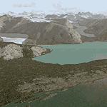
Glacier Bay v2 is a complete replacement of the default FS2004 landscape and scenery of more than 90,000 square kilometers (36,000 sq miles) of Southeast Alaska and adjacent areas of Yukon and British Columbia. File 1 of 2 (also requires glbayv2b.zip)
Landscape enhancements include high-resolution terrain mesh, detailed shorelines, rivers, lakes, and glaciers, and accurate land cover data with custom seasonal ground textures. Inland water bodies can be made to "freeze over" via an on/off switch. Other landmarks include the settlements of Juneau, Haines, Skagway, Yakutat, Atlin, and Carcross as well as road and railroad networks, cabins, lodges, and lighthouses. We modeled or enhanced 16 main airfields (plus one fictitious airstrip), 20 unlisted airstrips, 16 seaplane bases, and seven heliports. We've also included AI ship traffic in various locations as well as optional flightplans for GA and floatplane AI traffic.
Glacier Bay v2 is fully compatible with other third-party add-ons, including terrain mesh (FSGlobal, FS Genesis, etc.), ground textures (Ground Environment, BEV, FScene, etc.), and landscape enhancements (Ultimate Terrain Canada/Alaska, Misty Fjords, Tongass Fjords, Freight Dogs). A configurator panel (requires .Net Framework!) allows users to set compatibility options and to choose levels of scenery detail. We provide an autoinstaller and detailed documentation with a sectional map of the coverage area and a list of weblinks to real-world information.
For feedback and questions, please visit the Glacier Bay v2 support forum at http://forums.fsaddon.eu/viewforum.php?f=10. This project is a collaboration of nine FS developers from Germany, Austria, USA, and Canada, logging more than 1000 hours of work over the past 14 months. We acknowledge the kind support of FSAddon.com. However, this project is independent of any commercial company or product. Enjoy!
|
| Filename: |
glbayv2a.zip |
| License: |
Freeware, limited distribution |
| Added: |
28th May 2010, 19:34:54 |
| Downloads: |
41088 |
| Author: |
Holger Sandmann, Rainer Duda, Michael Eder, Scot Fraser, Manfred Herz, Jay Langham, Jon Patch, Larry Silsbee, and Jim Vile |
| Size: |
57818kb |
|
|
Other files which are related to, or may be required by, this file:
Images related to this file:
|
File Description:
Glacier Bay v2 is a complete replacement of the default FS2004 landscape and scenery of more than 90,000 square kilometers (36,000 sq miles) of Southeast Alaska and adjacent areas of Yukon and British Columbia. File 2 of 2 (also requires glbayv2a.zip)
Landscape enhancements include high-resolution terrain mesh, detailed shorelines, rivers, lakes, and glaciers, and accurate land cover data with custom seasonal ground textures. Inland water bodies can be made to "freeze over" via an on/off switch. Other landmarks include the settlements of Juneau, Haines, Skagway, Yakutat, Atlin, and Carcross as well as road and railroad networks, cabins, lodges, and lighthouses. We modeled or enhanced 16 main airfields (plus one fictitious airstrip), 20 unlisted airstrips, 16 seaplane bases, and seven heliports. We've also included AI ship traffic in various locations as well as optional flightplans for GA and floatplane AI traffic.
Glacier Bay v2 is fully compatible with other third-party add-ons, including terrain mesh (FSGlobal, FS Genesis, etc.), ground textures (Ground Environment, BEV, FScene, etc.), and landscape enhancements (Ultimate Terrain Canada/Alaska, Misty Fjords, Tongass Fjords, Freight Dogs). A configurator panel (requires .Net Framework!) allows users to set compatibility options and to choose levels of scenery detail. We provide an autoinstaller and detailed documentation with a sectional map of the coverage area and a list of weblinks to real-world information.
For feedback and questions, please visit the Glacier Bay v2 support forum at http://forums.fsaddon.eu/viewforum.php?f=10. This project is a collaboration of nine FS developers from Germany, Austria, USA, and Canada, logging more than 1000 hours of work over the past 14 months. We acknowledge the kind support of FSAddon.com. However, this project is independent of any commercial company or product. Enjoy!
|
| Filename: |
glbayv2b.zip |
| License: |
Freeware, limited distribution |
| Added: |
28th May 2010, 19:36:31 |
| Downloads: |
40390 |
| Author: |
Holger Sandmann, Rainer Duda, Michael Eder, Scot Fraser, Manfred Herz, Jay Langham, Jon Patch, Larry Silsbee, and Jim Vile |
| Size: |
88054kb |
|
|
File Description:
Connecting link between my river-main- and river-danube scenery. The following rivers in LWM-style are included:
* river Main from Bamberg to Wuerzburg (link to the river-main-scenery)
* Main-Donau-Canal from Bamberg to Dietfurt/Kelheim
* river Regnitz/Rednitz from Roth/Nbg to Bamberg
* river Altmuehl from Pappenheim to Dietfurt/Kelheim
* Aischgrund (hundred of lakes)
* lake Brombachsee
* lake Altmuehlsee
* lake Rothsee
* river Nahe from Norheim to Rhine
* river Lahn from Wetzlar to Rhine
| Filename: |
sgerrivs.zip |
| License: |
Freeware, limited distribution |
| Added: |
18th October 2003, 17:29:42 |
| Downloads: |
5268 |
| Author: |
Rainer Duda |
| Size: |
548kb |
|
|
File Description:
FS2002/FS2004 SW-German Rivers.
The following lakes and rivers in LWM-style:
Rhein, Schaffhausen Waterfall (Rheinfall), Neckar, Mosel, Bodensee, Feldsee, Titisee, Schluchsee, Stausee Losheim, Bostalsee, Talsperre Nonnweiler, Riveris-Talsperre, Eifel-Maare.
| Filename: |
swgerrvs.zip |
| License: |
Freeware, limited distribution |
| Added: |
30th December 2003, 00:00:08 |
| Downloads: |
7326 |
| Author: |
Rainer Duda |
| Size: |
1513kb |
|
  |


