|
AVSIM Library - Search Results
|
|
Login | Register | About logging in and out
|
Searching for:
in Flight Simulator 2004 - Scenery and below.
|

|
|
|
|
|
|
File Description:
Lake Of The Clouds - Ontonagon, Michigan scenery by Al Heline and Jim Bosworth.
This scenery includes the waterfalls on the Carp River on its way to Lk Superior.
Additional LandClass for Whitefish Point included.
| Filename: |
lotc.zip |
| License: |
Freeware, limited distribution |
| Added: |
4th February 2004, 04:22:08 |
| Downloads: |
2715 |
| Author: |
Al Heline, Jim Bosworth |
| Size: |
600kb |
|
|
File Description:
Update for "X4OX" Oxenhope private airfield. Improvements include better night textures, better placing of caravan park and the addition of more scenery. This airfield sit's ontop of a valley, and sits right next to a caravan park which offers a place to stay the night or camp, and spend a relaxing time in Bronteland, Yorkshire in the UK. For FS2002 or FS2004
| Filename: |
x4oxv1.1.zip |
| License: |
Freeware, limited distribution |
| Added: |
10th January 2004, 17:46:49 |
| Downloads: |
1841 |
| Author: |
Dale Sedgwick |
| Size: |
2609kb |
|
|
Images related to this file:

|
File Description:
In this airport reside AvioValtellina and VolaValtellina, as well as the operational base of the Health Service 118 and Mountain Rescue. It also base of the Aeroclub Sondrio with its Flight School VDS. Site at the beginning of the Valtellina, in Caiolo municipality (N46 09.0 E09 48.0), has an asphalt runway from 1050x23 mts, ground communication frequency 129.50; ICAO code: LILO. It is also enclosed the base of INAER Aviation, located in Colico-Piantedo (N46 08.18 E09 24.19 - code LIEI), that operates in Medical Emergency, rescue operations in the mountains and off-shore. Scenery realized on the real cooordinates of the airport (except for elevation) including the scenery of the heliport INAER Colico. Requires the use of the libraries' dva51 "and the system of vegetations "TreePlanter".
Enjoy!
A presentation video is available here.
|
| Filename: |
lilo_sondrio-caiolo.zip |
| License: |
Freeware |
| Added: |
25th October 2014, 11:52:25 |
| Downloads: |
812 |
| Author: |
Aldo Della Vedova |
| Size: |
30288kb |
|
|
File Description:
Fly over the city of Manila as you have never done it before!
Lots of landmarks of Manila city are represented in these files.
These files are optimized for a good frame rate performance.
| Filename: |
manila_08_v1.zip |
| License: |
Freeware |
| Added: |
8th May 2008, 19:49:15 |
| Downloads: |
7757 |
| Author: |
Nestor D'Angelo |
| Size: |
6946kb |
|
|
File Description:
Upon the permission of the author, this scenery enhancement is released as a separate download compatible for RPLL v8 or later. Please see Installation readme for details.
| Filename: |
manila_08_v2.zip |
| License: |
Freeware, limited distribution |
| Added: |
22nd November 2011, 08:21:35 |
| Downloads: |
3539 |
| Author: |
Lowil Espada for Nestor D'Angelo |
| Size: |
5340kb |
|
|
File Description:
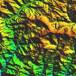
Highly detailed terrain mesh of the Namcha Barwa area, N29�-31� E94�-96�. The files in this package are based on Shuttle Radar (SRTM) Version 2 data but with many of the void areas, especially the most significant sections, filled with elevation data generated from topographic maps by Jonathan de Ferranti. While Jonathan's work is unrelated to flight simulation he kindly gave me permission to compile his data for use in FS. The result is a wonderful improvement in detail and accuracy over any existing mesh file, freeware or commercial, based on SRTM or DTED data alone. Due to the large area of the Himalayas I've compiled the source data as two separate series: the "Himalayan Peaks" series covers prominent mountains and ranges in higher detail and locally overrides any existing LOD9 terrain mesh. In addition, a LOD9 "base mesh" series covering the entire Himalayas will be available for those who do not yet have an add-on terrain mesh of these beautiful mountains.
| Filename: |
fs_him_03.zip |
| License: |
Freeware, limited distribution |
| Added: |
18th February 2006, 23:15:17 |
| Downloads: |
12139 |
| Author: |
Holger Sandmann and Jonathan de Ferranti |
| Size: |
15451kb |
|
|
|
File Description:
Highly detailed terrain mesh of the Annapurna area, N28-30 E83-85. The files in this package are based on Shuttle Radar (SRTM) Version 2 data but with many of the void areas, especially the most significant sections, filled with elevation data generated from topographic maps by Jonathan de Ferranti. While Jonathan's work is unrelated to flight simulation he kindly gave me permission to compile his data for use in FS. The result is a wonderful improvement in detail and accuracy over any existing mesh file, freeware or commercial, based on SRTM or DTED data alone.
Due to the large area of the Himalayas I've compiled the source data as two separate series: the "Himalayan Peaks" series covers prominent mountains and ranges in higher detail and locally overrides any existing LOD9 terrain mesh. In addition, a LOD9 "base mesh" series covering the entire Himalayas will be available for those who do not yet have an add-on terrain mesh of these beautiful mountains.
|
| Filename: |
fs_him_04.zip |
| License: |
Freeware, limited distribution |
| Added: |
29th May 2010, 08:59:29 |
| Downloads: |
10414 |
| Author: |
Holger Sandmann, Jonathan de Ferranti |
| Size: |
15427kb |
|
|
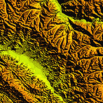
File Description:
Highly detailed terrain mesh of the Garhwal area, N30�-32� E78�-81�. The files in this package are based on Shuttle Radar (SRTM) Version 2 data but with many of the void areas, especially the most significant sections, filled with elevation data generated from topographic maps by Jonathan de Ferranti. While Jonathan's work is unrelated to flight simulation he kindly gave me permission to compile his data for use in FS. The result is a wonderful improvement in detail and accuracy over any existing mesh file, freeware or commercial, based on SRTM or DTED data alone. Due to the large area of the Himalayas I've compiled the source data as two separate series: the "Himalayan Peaks" series covers prominent mountains and ranges in higher detail and locally overrides any existing LOD9 terrain mesh. In addition, a LOD9 "base mesh" series covering the entire Himalayas will be available for those who do not yet have an add-on terrain mesh of these beautiful mountains.
| Filename: |
fs_him_05.zip |
| License: |
Freeware, limited distribution |
| Added: |
18th February 2006, 23:16:47 |
| Downloads: |
10071 |
| Author: |
Holger Sandmann and Jonathan de Ferranti |
| Size: |
28382kb |
|
|
|
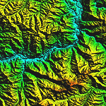
File Description:
Highly detailed terrain mesh of the Jammu and Kashmir areas, N31-36 E76-78. The files in this package are based on Shuttle Radar (SRTM) Version 2 data but with many of the void areas, especially the most significant sections, filled with elevation data generated from topographic maps by Jonathan de Ferranti. While Jonathan's work is unrelated to flight simulation he kindly gave me permission to compile his data for use in FS. The result is a wonderful improvement in detail and accuracy over any existing mesh file, freeware or commercial, based on SRTM or DTED data alone.
Due to the large area of the Himalayas I've compiled the source data as two separate series: the "Himalayan Peaks" series covers prominent mountains and ranges in higher detail and locally overrides any existing LOD9 terrain mesh. In addition, a LOD9 "base mesh" series covering the entire Himalayas will be available for those who do not yet have an add-on terrain mesh of these beautiful mountains.
|
| Filename: |
fs_him_06.zip |
| License: |
Freeware, limited distribution |
| Added: |
29th May 2010, 08:55:43 |
| Downloads: |
9606 |
| Author: |
Holger Sandmann, Jonathan de Ferranti |
| Size: |
53444kb |
|
|
|
File Description:
Highly detailed terrain mesh of the Karakoram area, N35-37 E73-77. The files in this package are based on Shuttle Radar (SRTM) Version 2 data but with many of the void areas, especially the most significant sections, filled with elevation data generated from topographic maps by Jonathan de Ferranti. While Jonathan's work is unrelated to flight simulation he kindly gave me permission to compile his data for use in FS. The result is a wonderful improvement in detail and accuracy over any existing mesh file, freeware or commercial, based on SRTM or DTED data alone.
Due to the large area of the Himalayas I've compiled the source data as two separate series: the "Himalayan Peaks" series covers prominent mountains and ranges in higher detail and locally overrides any existing LOD9 terrain mesh. In addition, a LOD9 "base mesh" series covering the entire Himalayas will be available for those who do not yet have an add-on terrain mesh of these beautiful mountains.
|
| Filename: |
fs_him_07.zip |
| License: |
Freeware, limited distribution |
| Added: |
30th May 2010, 09:56:27 |
| Downloads: |
9420 |
| Author: |
Holger Sandmann, Jonathan de Ferranti |
| Size: |
39503kb |
|
  |


