|
AVSIM Library - Search Results
|
|
Login | Register | About logging in and out
|
|
Searching for: 'sandmann ' in Flight Simulator 2004 - Scenery and below.
|

|
|
|
|
|
|
Other files which are related to, or may be required by, this file:
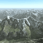
Images related to this file:
|
File Description:
Yet another terrain mesh package of the European Alps? Well, this one is different in that it is NOT primarily based on the Shuttle Radar (SRTM) data with their incomplete coverage of prominent peaks and ridges. Instead, most of the source data for this project were developed over many months by Jonathan de Ferranti using detailed topographic maps. While Jonathan's work is unrelated to flight simulation he kindly gave me permission to compile his data for use in FS. The result is a wonderful improvement in detail and accuracy over any existing SRTM- or DTED-based mesh file, freeware or commercial (a link to an extensive set of screenshot comparisons is included in the read-me file).
I've compiled the source data at LOD10 (38-m) grid resolution because the coverage area is smaller than most existing mesh files. Thus, anyone can use these files without having to first uninstall their current mesh set. Also included are LOD9 and LO8 buffer mesh files. Note: if you own Switzerland Professional with its high-resolution terrain mesh then you don't need this package, at least not the Switzerland files!
|
| Filename: |
alpsw_fe.zip |
| License: |
Freeware, limited distribution |
| Added: |
30th May 2010, 09:51:03 |
| Downloads: |
58803 |
| Author: |
Holger Sandmann, Jonathan de Ferranti |
| Size: |
51234kb |
|
|
Other files which are related to, or may be required by, this file:
File Description:
Patch files to remove tall spike in terrain near Salzburg at N47 44´ E13 00´ and to add the missing/distorted peaks of La Grande Moucherolle at N45 00´ E5 34´ and Mont Aiguille at N44 50' E5 33'.
Requires the full version of our Alps LOD10 mesh files, alpse_fe.zip and alpsw_fe.zip. Source data by Jonathan de Ferranti, compiled for FS by Holger Sandmann. Fully compatible with FS2002. A big thank-you to those who reported the "Salzbug" and the missing peaks in the French Alps.
| Filename: |
alps_up1.zip |
| License: |
Freeware, limited distribution |
| Added: |
9th February 2006, 15:02:59 |
| Downloads: |
32221 |
| Author: |
Holger Sandmann, Jonathan de Ferranti |
| Size: |
2635kb |
|
|
|
File Description:
One of the most spectacular watersheds of British Columbia's Midcoast, the Bella Coola Valley looks pretty boring in its default FS rendition. These files provide a LOD10 (38-m) mesh made from CDED1 0.75-arcsec data, a new landclass file, and accurate placements of lakes, rivers, streams, and roads. Also includes the glaciers of the Monarch Mt. Icefield and several forestry roads and clearcuts along the side valleys. Made with Ground2K4 based on Landsat 7 ETM+ satellite imagery.
| Filename: |
bc_bella.zip |
| License: |
Freeware, limited distribution |
| Added: |
1st April 2004, 20:49:32 |
| Downloads: |
8839 |
| Author: |
Holger Sandmann |
| Size: |
21239kb |
|
|
File Description:
Calgary, Alberta, Canada
Version 1.1
This version contains the same 58 downtown buildings including the Calgary Tower and over 40 of the largest buildings, as of September, 2006. There are no new buildings in this version but several scenery (terrain) files have been added which replace Microsoft's default scenery for the Calgary area. This allows all the downtown buildings to be moved to their proper location rather than sitting in the default Bow River which looked more like a long lake. This version should work with Ultimate Terrain and other add on scenery files such as Holger Sandmann's bcmesh9e. Other enhancements include some VFR scenery based on the VFR Terminal Area Chart for Calgary, a more realistic Bow River, Elbow River, Glenmore Reservoir, Chestermere Lake and Ghost Lake.
| Filename: |
calgary1.1.zip |
| License: |
Freeware |
| Added: |
18th May 2010, 02:18:28 |
| Downloads: |
1539 |
| Author: |
Rick Engler |
| Size: |
752kb |
|
|
File Description:
FS2004 Scenery - This file creates 12 new airports in six of Canada's National Parks (Banff, Jasper, Kootenay, Yoho, Glacier and Mt Revelstoke). Required is Holger Sandmann's excellent BC mesh, which is the reason for this file in the first place, and Lago's FSE demo file. Pack designed for low level visual 30 mile scenic flights with some tourist attraction additions (Takakkaw Falls, Emerald Lake, Lake Louise, Morainne Lake, Spiral Tunnel etc). The strips are ficticious, but the names and places are real. There is parking for you to add your own AI traffic as well. There are also improvements to other area strips (mainly lights and taxiways). Six flights included.
| Filename: |
cmpcanmtpks_v1.zip |
| License: |
Freeware |
| Added: |
11th April 2004, 23:15:31 |
| Downloads: |
5236 |
| Author: |
Peter Vibe |
| Size: |
1734kb |
|
|
File Description:
This project features the Blue Mesa Reservoir and the Black Canyon of the Gunnison and adds over 300 highly detailed lakes to the central portion of western Colorado. Three reservoirs, named for corresponding dams on the Gunnison River, form the heart of Curecanti National Recreation Area. Panoramic mesas, fjord-like reservoirs, and deep, steep and narrow canyons abound. Blue Mesa Reservoir is Colorado's largest body of water, and is the largest Kokanee Salmon fishery in the United States. Morrow Point Reservoir is the beginning of the Black Canyon of the Gunnison and below it is Crystal Reservoir.
These lakes are specifically designed to show off their photo realistic detail when used in combination with "FSGenesis-The Rockies 38.2m Terrain Mesh-Colorado" available as "fsg_dem38m_usrk_co.zip" at avsim.com, or comparable mesh. The free FSGenesis US National Landclass Project Beta 6 also adds beautifully to the landscape. These lakes work equally as well with the default mesh.
All lake information was projected from satellite imagery and compiled with a beta version of Jim Keir's "Slartibartfast" utility. Much thanks to Holger Sandmann and Jim Keir for their help and advice on interpreting the satellite data properly.
| Filename: |
colorado_lakes_project_2.zip |
| License: |
Freeware |
| Added: |
1st June 2004, 02:34:42 |
| Downloads: |
6032 |
| Author: |
Carlyle Sharpe |
| Size: |
332kb |
|
|
Images related to this file:
File Description:
The town of Chetwynd (population around 2,600) is on the east side of the Rocky Mountains, the first town to be encountered when descending from the Rockies on highway 97. Previously known as Little Prairie, the town name was changed in 1962. The main occupations of the town are linked to forestry, fossil fuels, and transportation; there are railway lines north to Fort St John, east to Dawson Creek, and south to Prince George. The airport is on the southern side of the town, with one runway aligned 05-23, asphalted in 1975 and just under 4,500 feet long. There are no scheduled services, although a new terminal building was constructed in 2008, and the helicopter operations by at least two companies (oil and gas and medical evacuation flights) are the primary operations from the field. These are included in the AI, incorporating helicopter modifications made by Holger Sandmann so that they function properly as AI at an airfield. As an aside, landing like a plane and using the runway and taxiways is in fact exactly what a helicopter does at a normal airfield in real life; everyone does the same thing so that guessing is unneccesary.
| Filename: |
chetwynd.zip |
| License: |
Freeware, limited distribution |
| Added: |
28th March 2016, 21:36:33 |
| Downloads: |
289 |
| Author: |
Roger Wensley |
| Size: |
20094kb |
|
|
File Description:
Excursion Inlet is in Alaska and in the area covered by Holger Sandmann's scenery called "Glacier Bay" which you will need to have already installed. It might work with just Ultimate Terrain, but then there will be no float base in the same inlet (nicely modelled by Holger and the team) which from the air is pushed off to one side (as a significant landmark, not literally!) by a large cannery which has been there since 1908. And rebuilt several times, I hasten to add, so don't think you're getting a museum piece here. And the only thing nearby that looms larger than the cannery is nature; lots of water, mountains, and trees. For me to start this Holger's scenery had to be there, so without it you won't get the same result.
| Filename: |
excursion_inlet_cannery.zip |
| License: |
Freeware |
| Added: |
17th June 2008, 07:37:59 |
| Downloads: |
1455 |
| Author: |
Roger Wensley & Jim Turner |
| Size: |
1473kb |
|
|
File Description:
Based on googleEarth and fotos. Ez-scenery and rwy12 objects included. Includes the airport, as well as landclass for the town of Arandis and a textured area to represent the uranium mine east-south-east of the airport. Roads in the vicinity have been added and adjusted. Compatible with Holger Sandmann's Namibia LOD9 Terrain mesh (namibia_ne.zip, namibia_nw.zip, namibia_se.zip, namibia_sw.zip, namibia_cp.zip) as well as his namibia_scenery_updates.zip, all found at avsim.com.
| Filename: |
fyar.zip |
| License: |
Freeware |
| Added: |
4th January 2009, 12:17:39 |
| Downloads: |
857 |
| Author: |
Detlev J. Rohmer |
| Size: |
7675kb |
|
|
File Description:
FYKM Katima Mulilo Airport, Mpacha, Namibia for FS9. Needs ez-scenery and/or rwy12 objects. I recommend to download "ezoliv33.zip" from flightsim.com (205 MB!), which is a collection of all available ez scenery object libraries. Compatible with the LOD9 (76-m) Terrain Mesh of Namibia, southwestern Africa, by Holger Sandmann found at avsim.com (File Names: namibia_ne.zip, namibia_nw.zip, namibia_se.zip, namibia_sw.zip, namibia_cp.zip) as well as his Landclass and Scenery enhancements of Namibia (namibia_lc.zip). Not tested with default scenery.
| Filename: |
fykm.zip |
| License: |
Freeware |
| Added: |
8th November 2008, 00:14:34 |
| Downloads: |
1222 |
| Author: |
Detlev J. Rohmer |
| Size: |
1204kb |
|
  |


