|
AVSIM Library - Search Results
|
|
Login | Register | About logging in and out
|
|
Searching for: 'military ' in Flight Simulator 2004 - Scenery and below.
|

|
|
|
|
|
|
Images related to this file:
File Description:
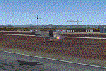
There are four main northwestern Alaska towns which have good airports and are serviced by Alaska Airlines. From these airports local flights connect to nearby villages, "nearby" in Alaska meaning up to 200 miles away. The northernmost is Barrow. Southwest of Barrow is Kotzebue, then Nome, and the furthest south is this one, Bethel. The town of Bethel has a population of just over 6,000 and is 50 miles from the sea on the Kuskowim River, that splits and forks into many tributaries. Bethel Airport is close to the town and provides the only contact with the rest of Alaska, as there is no connecting highway system. There are scheduled flights by Alaska Airlines, ERA (now called Ravn) and Grant Aviation, plus others such as Ryan Air. There are cargo flights by Everts, Northern, and Lynden, and redistribution onwards to nearby villages by the smaller locally-based planes; all of these are included in the AI. There are two main runways, one just under 6,400 feet and another just under 3,900 feet, both of them aligned 19-1. The third runway is around 1,800 feet and mainly gravel, aligned 11-29. Parking at PABE is on three aprons, the northern for smaller commercial planes of Grant, ERA, Ryan etc, the central for larger planes of Alaska, Northern, Everts, and Lynden, and the southern for a large collection of GA; each apron has further hangars for maintenance companies and smaller operators. There is also another separate apron for the local military and Coastguard. There is not much photographic information available for PABE, and I have never been there; as a result it was impossible to make detailed photographic textures for some of the buildings. However, for most hangars I have made textures of at least the right colour etc based on the information I assembled and if it is green with white trim and side windows then that is how it now appears here. The exceptions are the Alaska Airlines terminal building which has complicated curved elements, and the two military hangars and workshops where I had to settle for an Alaska terminal building from another airport and the same for the military. There are numerous small villages in the vicinity of Bethel, all of them being beside either a river tributary or the coast. There are two Google Earth screenshots to show the villages that are served by the flights from Bethel and that are (mostly) included in the AI. Some of these airfields were not included in FS9 but AI will still operate in and out of Bethel. The smaller area screenshot shows the villages that are close to Bethel, and of these eight I have so far made six and they are included in this post: Napaskiak PKA, Napakiak WNA, Kwethluk KWT, Atmautluak 4A2, Nunapitchuk 16A, and Kasigluk Z09. I will work my way through the rest of the area.
| Filename: |
bethel_373821.zip |
| License: |
Freeware, limited distribution |
| Added: |
8th March 2019, 00:37:58 |
| Downloads: |
274 |
| Author: |
Roger Wensley |
| Size: |
33760kb |
|
|
File Description:
The Boise airport had outdated default scenery, so I created improved scenery with a new control tower and additional taxiways. I also included scenery for the military helicopter BOI2. Please read my readme.txt for more information.
| Filename: |
kboi_396736.zip |
| License: |
Freeware |
| Added: |
6th February 2024, 18:08:22 |
| Downloads: |
49 |
| Author: |
Stuart John Gilbert II |
| Size: |
4788kb |
|
|
|
Other files which are related to, or may be required by, this file:
Images related to this file:
File Description:
Boundary Bay is south of Vancouver in British Columbia, close to the US/Canada border. It is the 5th busiest airfield in Canada measured in terms of take offs and landings as there are several training companies based there. The airfield was purchased by Alpha Aviation in 2009 and and modernised for the 2010 Winter Olympics, the main addition being a new terminal. This is an ex-military training base which was built in 1941, and one of the original hangars still survives. The two runways in use now (07/25 5,600' and 12/30 2,750', both of them 100' wide) are reduced asphalted areas of the original runways; the third runway is now an apron for GA parking and has had hangars built along it. There is JetA and 100LL available. The large building at the east end of the north apron is a HQ and maintenance facility for a helicopter company, Heli-one. All of the north apron buildings on the field have been modelled specifically for this scenery, plus the nearby huge greenhouse farm structures which are visible from further away than the airfield is. AI for Boundary Bay will be posted later this week.
| Filename: |
boundary_bay.zip |
| License: |
Freeware, limited distribution |
| Added: |
12th May 2011, 13:30:18 |
| Downloads: |
838 |
| Author: |
Roger Wensley |
| Size: |
4657kb |
|
|
File Description:
Scenery of LIPB Bolzano airport (Trentino-Alto Adige).
Features also the military zone, the flying club and the Hospital Heliport.
Completely designed using Gmax.
Compatible with Fs9 default.
For the best results, it is useful to have Ultimate Terrain Europe installed in your system.
| Filename: |
bozendolomiten.zip |
| License: |
Freeware, limited distribution |
| Added: |
17th December 2008, 10:26:18 |
| Downloads: |
7821 |
| Author: |
Claudio "Werwolf" Carra |
| Size: |
5966kb |
|
|
Images related to this file:
File Description:
Burg military airfield, Paratrooper-training base-40. The airfield Cottbus is the one field of a row of military airfield sceneries. In the scenery are included the airfield and the technical supplies.
The airfield was put into operation in 1982 in duty of the NVA. Here were trained paratroopers of the NVA and other airborne-units.
| Filename: |
burg.zip |
| License: |
Freeware |
| Added: |
4th May 2012, 15:51:13 |
| Downloads: |
463 |
| Author: |
Volker Loew, Frithjof Koch |
| Size: |
1465kb |
|
|
Images related to this file:
|
File Description:
The following files are required by this file:
http://library.avsim.net/esearch.php?DLID=163723&UploadID=&Name=&FileName=&Author=&CatID=root
http://library.avsim.net/esearch.php?DLID=186350&UploadID=&Name=&FileName=&Author=&CatID=root
This scenery includes a global review of the previous Sceneries of Cameri Military airport (rev.2 Oct 2011), Cameri Museum (rev. 2 Oct 2011), Cameri Babini (rev. 2 oct 2011), Turbigo power station (rev. 2 Sep 2011 and update rev. 2.1 Oct 2014). All the above ARE NOW INCLUDED in this new unique scenery. Contents: Terrain in new version photo-realistic multi-seasons/night; adapted to Western Europe special elevation meshes; cover area of over 120 sqkm from Bellinzago-Oleggio (NW) to Magnago-Bienate (NE), from Novara (SW) to Cuggiono-Inveruno (SE); all the terrain has been restorated with 3D buildings, either through autogen that with specific dedicated objects (by GMax) and with significant addition of library objects ("dva51" and other existings). This scenery (located on the final approach to the Milan Malpensa international airport) includes the Cameri's Mil Airport with the Babini closed Army area and the planes of the Historical Museum of the airport; it is also included the thermoelectric power station of Turbigo. All the buildings are placed to recreate cities and villages covered in the photo-realistic terrain, including Bellinzago, Bienate, Buscate, Caltignaga, Cameri, Castano Primo, Castelletto Ticino, Cuggiono, Galliate, Inveruno, Magnago, Malvaglio, Nibbia, Novara, Oleggio, Pernate, Robecchetto, Romentino, Sant'Anna, San Pietro Mosezzo, Turbigo , Vanzaghello, and the covered Turin-Milan highway.
Details of the new buildings for the care and maintenance to F35 completely recreated, as obtainable from the current satellite view.
It REQUIRES the use of the following, to be downloaded separately :
- the libraries dva51 - the system of vegetations TreePlanter - the West Europe Meshes of Daniele Lanfranchi. See the Readme file. Enjoy!
Videos available here:
https://dl.dropboxusercontent.com/u/38829151/FS9/Cameri_Turbigo_v3%20shots.WMV
http://youtu.be/yVI2KeJKS5o
http://youtu.be/oKa0e_5kxIk
|
| Filename: |
cameri-turbigo_v3.zip |
| License: |
Freeware |
| Added: |
21st January 2015, 21:32:36 |
| Downloads: |
922 |
| Author: |
Aldo Della Vedova, Daniele Lanfranchi and Gian Mario Verga |
| Size: |
107266kb |
|
|
File Description:
Camp Dawson 3G5 WV is a real world training post for ARNG and others in northern West Virginia. I don't like making military sceneries very accurate for obvious reasons. The runway and the roads are close to what you see as you fly over the Camp. My afcad is included inside the scenery folder. Thanks to those AVSIM object makers and credits are in readme file.
| Filename: |
dawsonaaf-3g5.zip |
| License: |
Freeware |
| Added: |
27th August 2005, 01:30:52 |
| Downloads: |
1005 |
| Author: |
Rick Connolly |
| Size: |
2827kb |
|
|
File Description:
This file installs under FS2004 a good reproduction (thanks go to Google Earth and AFX) of the Little airport LIAU Capua, Italy. It consists in a simple dirt runway for VFR GA planes with no apron of sorts (even in Real Life it's like that), long about 3300 feet and wide about 75 feet, few miles inland from the military airport of Grazzanise LIRM.
For all the VFR pilots, Italians and/or from afar, who like to fly in FS2004 Italy.
| Filename: |
liau.zip |
| License: |
Freeware |
| Added: |
16th April 2009, 19:24:05 |
| Downloads: |
559 |
| Author: |
Iandiorio Sabato |
| Size: |
3kb |
|
|
Other files which are related to, or may be required by, this file:
Images related to this file:
|
File Description:
This scenery package contains twelve airports in Germany, nine in the Netherlands, one in Luxembourg, three in Switzerland , and three in Austria - providing taxiways and details as they were at the beginning of the 1960's.
We also created the harbors of Rotterdam, Hamburg and Den Helder, all the lighthouses along the Dutch coast and some along the German coast, and created the island of Helgoland from scratch. Although most of the airports of the package are for civil use, we also produced some Dutch military bases with AI and static aircraft. At many of the airports you will find moving crash tenders and at Amsterdam moving airport buses. Although we did not always have enough photos and information we tried to come as close as possible. Our goal was to reflect something of the atmosphere and feel of that period, prior to the all-jet era of today.
|
| Filename: |
central_europe_1961.zip |
| License: |
Freeware, limited distribution |
| Added: |
17th May 2013, 20:07:54 |
| Downloads: |
6390 |
| Author: |
Wolfgang Gersch, Harry Biard, Michael Schneider,Jaap de Baare, Nikko Yaginuma, Tom Gibson, Bernard Leuenberger and Mike Stevens |
| Size: |
56570kb |
|
|
File Description:
CFB North Star (CYNS) fictional Canadian military base for FS2004. This is a complete rework of the previous offering. Features two runways of 12,500' length, custom buildings, and numerous "extras". Liven up the Great White North. FREEWARE by Brian Sturton.
| Filename: |
yns91_9.zip |
| License: |
Freeware, limited distribution |
| Added: |
18th March 2009, 18:30:16 |
| Downloads: |
299 |
| Author: |
Brian Sturton |
| Size: |
3912kb |
|
  |


