|
AVSIM Library - Search Results
|
|
Login | Register | About logging in and out
|
|
Searching for: 'mesh' in Flight Simulator X - Scenery and below.
|

|
|
|
|
|
|
File Description:
Anegada, British Virgin Islands,
including
the correct redefinition of coasts and landscape
-airport: Capt Auguste George (TUPA) ville :The Settlement
running Window XP and Vista: FSX SP1 and SP2
Please Note:
This scenery works with the MESH in LOD 10 (30 m) of Caribbean arc that I have
generated from Nasa GDEM and deposited on the same web site files in a file
named Meshantilles.zip
| Filename: |
anegadav2.zip |
| License: |
Freeware |
| Added: |
26th July 2013, 17:22:11 |
| Downloads: |
1065 |
| Author: |
Valladier Jean Louis |
| Size: |
45845kb |
|
|
File Description:
Revised accurate afcad and Scenery for Araxos AB
- 116 Combat Wing
335 Mira "Tigris" (Tigers) and 336"Olymbos" (Hawk)
Served by A-7E TA-7C
Installation
1.Copy the .bgl Files in the folder to Microsoft FLight Simulator X\Addon Scenery\scenery\
2.Run FSX
3.You might have to activate this first
Works with Greece MESH TERRAIN Scenery v1 for FSX by Panos Georgotas member of:
Hellas Scenery Project (HSP)
| Filename: |
araxos_ab_greece.zip |
| License: |
Freeware |
| Added: |
1st January 2008, 21:50:07 |
| Downloads: |
2338 |
| Author: |
Alan Mccarthy |
| Size: |
189kb |
|
|
|
File Description:
"The archipelago of St Pierre (LFVP) and Miquelon (LFVM)".
Theses islands are situated in the south of New Foundland island, beetwin Canada and United States.
All the archipelago is made up of a new local mesh, landclass, photorealists textures in 2m/pixel in St-Pierre island (4 seasons and the night) with specific autogen, the harbour, various buildings, churches, and reference marks
visual.
The airport of St-Pierre (LFVP) is created with a non-flat runway, as it
is in reality, whith a true lenght profil.
A basic mission named "De Miquelon � St Pierre" is placed at "beginner"
level for discover easely the archipelago.
This scenery is only for FsX and is not compatible with Fs 2004 (Fs9)."
| Filename: |
st-pierre_miquelon.zip |
| License: |
Freeware, limited distribution |
| Added: |
4th July 2008, 16:11:23 |
| Downloads: |
3881 |
| Author: |
Marc-henri Guitteny |
| Size: |
17825kb |
|
|
Images related to this file:
|
File Description:
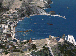
The city of Avalon on Catalina Island with many custom built objects including the Turret House, Wrigley Memorial, Pier, working Bell Tower (sounds), and several businesses and hotels. This scenery was designed around the freeware Catalina Island by Aerosoft and is required for this scenery to display correctly. FS2002 version of this scenery has over 5500 downloads. Tested on FSX Gold Edition (FSX Deluxe and Acceleration Expansion Pack), FSGenesis 9.6 terrain mesh, and Win7 operating system. Requires RWEOBJv5.zip & RWEOBJc5.zip (or later) Object Libraries. By Ron Ezra
|
| Filename: |
avalonv5.zip |
| License: |
Freeware |
| Added: |
14th January 2016, 19:29:50 |
| Downloads: |
811 |
| Author: |
Ron Ezra |
| Size: |
1562kb |
|
|
File Description:
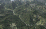
One of the most spectacular watersheds of British Columbia's Midcoast, the Bella Coola Valley looks pretty boring in its default FSX rendition and the oddly shaped default Bella Coola River cuts deep into the terrain. These files provide a terrain mesh made from CDED1 0.75-arcsec data (multi-LOD, with maximum resolution of 38-m grid spacing), updated land class, water class, and seasons files, and accurate placements of lakes, rivers, streams, roads, and bridges. Also added are the glaciers of the Monarch Mountain Icefield as well as several forestry roads and clearcuts in the side valleys. Main roads have vehicle traffic moving in both directions. Coverage area is N51*45'-52*40' and W125*35'-127*25'. These files are fully compatible with other landscape enhancements for FSX, such as FS Genesis North America terrain mesh, Cloud 9's X-class, Adam Mill's ground texture replacements, or Flight1's Ultimate Terrain Canada/Alaska.
| Filename: |
bellafsx.zip |
| License: |
Freeware, limited distribution |
| Added: |
24th February 2007, 08:27:54 |
| Downloads: |
12620 |
| Author: |
Holger Sandmann |
| Size: |
16058kb |
|
|
Other files which are related to, or may be required by, this file:
Images related to this file:
|
File Description:
This project adds and updates all of the airports of Bhutan. Bathpalathang (VQBT) and Gelephu (VQGP) are added, Yongphulla (VQ10) is updated and recoded as VQTY, and Paro (VQPR) is fully updated to reflect current satellite imagery. These are all fully functioning AI airports as well. Special attention was given to the entire Paro Valley, and numerous road/river vectors were updated around Gelephu. Accurate coastlines, lakes, road and river data, as well as corrected landclass are provided based on the latest available satellite imagery. They are optimized to fit seamlessly with FTX Vector's roads/water, but they should be fully functional in all FSX configurations.
GA-encoded flight plans for the Buddha Air/Kathmandu charter are provided to enhance service to Paro. NASA SRTM Global 3 arc second terrain mesh is also included for all of Bhutan. Updates were created or rebuilt in a manner which carefully aligned airport data with current satellite imagery, when available. Scenery was created using Airport Design Editor X v1.61.5298, SBuilderX 3.13, and the FSX Object Placement Tool. Scenery objects were added and modified from stock FSX scenery to resemble as closely as possible the actual airports.
|
| Filename: |
bhutan_airports_and_paro_valley.zip |
| License: |
Freeware |
| Added: |
19th January 2015, 06:09:17 |
| Downloads: |
10784 |
| Author: |
Carlyle Sharpe |
| Size: |
21861kb |
|
|
File Description:
A scenery for Voss airport Bomoen (B�moen), ENBM,in Norway. Perfectly fits with the Norwegian landclass and mesh files for FSX too. Please read the included text file for more information.
Have fun!
| Filename: |
bmx1.0.zip |
| License: |
Freeware |
| Added: |
16th April 2007, 14:03:03 |
| Downloads: |
2411 |
| Author: |
Geir Groenlien |
| Size: |
4963kb |
|
|
File Description:
These file supersedes all my previous BOP Islands releases and was re-uploaded due to the AVSIM hack- It contains all of the 4 BOP Island releases (including the High Resolution Whale Island aerial and mesh).
Sceneries contain autogenned aerial images, placed objects, effects and runways where appropriate in order to increase the realism of these Islands off the coast of New Zealand.
| Filename: |
bopislands_redux.zip |
| License: |
Freeware, limited distribution |
| Added: |
17th April 2010, 19:38:50 |
| Downloads: |
1645 |
| Author: |
Tim Barnes |
| Size: |
56855kb |
|
|
File Description:
Brisland Bridge Air Park (WAHC) by Bill and Phil specifically for FSX. Designed for use with Ultimate Terrain X (UTX), the FSX Mesh Resolution set to 10m, the Mesh Resolution set to 80, and some older (FS9) object libraries (see list below). Other settings or without UTX installed, may cause unpredictable results... like the airport sitting on a plateau or the nearby lake missing. It won't hurt anything but may look strange.
| Filename: |
brisland_bridge_air_park.zip |
| License: |
Freeware, limited distribution |
| Added: |
12th October 2007, 02:26:17 |
| Downloads: |
960 |
| Author: |
Bill Dick and Phil Cayton |
| Size: |
79kb |
|
|
File Description:
British and US Virgin Islands,including the correct redefinition of coasts islands and landscape.
Includes 3 airports:
-The Cyril E. King airport at St. Thomas located on the southwestern side of St Thomas US Virgin Isl (TIST)
-Terrance B Lettsome Intl Airport Information. Located in Tortola, Virgin Isl (br) : TUPJ
-Virgin Gorda Airport located in Virgin Gorda, Virgin Islands,(br): TUPW and MESH in LOD 10 (30 m) of Virgins islands arc
| Filename: |
ilesviergesv2.zip |
| License: |
Freeware |
| Added: |
23rd May 2014, 22:32:37 |
| Downloads: |
2731 |
| Author: |
Valladier Jean Louis |
| Size: |
14467kb |
|
  |


