|
AVSIM Library - Search Results
|
|
Login | Register | About logging in and out
|
|
Searching for: 'fs-blaze' in AVSIM File Library and below.
|

|
|
|
|
|
|
File Description:
"Swiss hangar" is a large repaint collection for payware and freeware aircraft that will give you the opportunity to fly over the FS 2004 swiss and european sky with aircraft in original swiss livery. Every aircraft is perfectly reproduced like the original one. Drawing are based on the author photo documentation or from photos available on internet (Airliners.net, MyAviation.net etc.) For the "payware" Piper Cherokee of CARENADO (www.carenado.com) I have painted several livery of real life Pipers from the major clubs and flying school of Switzerland. This aircraft, Piper Cherokee HB-OHX belongs to "Elkair" a group of friends that organize flying holidays in Scandinavia and is based on the regional Bern-Belp airport (BRN/LSZB), Bern.
| Filename: |
carenado_piper_cherokee_180_hb-ohx.zip |
| License: |
Freeware |
| Added: |
28th April 2007, 11:50:35 |
| Downloads: |
1597 |
| Author: |
Antonio Iozzi / Carenado |
| Size: |
4004kb |
|
|
File Description:
This tutorial offers tips to enhance your Flight Simulator realism.
Covers: Simulated flights realism, how to make FS look real, being an experienced captain,
inside the aircraft, and more!
A must-have tutorial!
For FS98 thru FS2004 pilots who cares about flight simulation realism.
| Filename: |
fs_realism.zip |
| License: |
Freeware, limited distribution |
| Added: |
30th July 2004, 00:55:42 |
| Downloads: |
24303 |
| Author: |
Luciano Ferreira |
| Size: |
356kb |
|
|
|
Images related to this file:

|
File Description:
This is a repaint for the payware Warbirdsim P-51D "Mustang Tales" product. This is a new and vastly improved/updated version of my previous repaint, depicting the restored P-51D (F-6K) 44-12852, owned by Dan Friedkin/Comanche Fighters, based at Comanche Ranch, Eagle Pass, Texas. The aircraft is painted in the markings of General Tommy Hayes' P-51D-5-NA "Frenesi", of the 364th FS, 357th FG, 8th AF, which was named after the 1940 Artie Shaw tune. Starting in 2009, this aircraft was sent to Midwest Aero Restorations for restoration to complete WWII-stock condition/configuration, and first flew in January 2017. This repaint is stand-alone and does not require my previous version to be installed. New bump maps and modified cockpit textures included.
|
| Filename: |
jt_p51_frenesi_v2.zip |
| License: |
Freeware |
| Added: |
7th July 2017, 17:11:01 |
| Downloads: |
153 |
| Author: |
John Terrell |
| Size: |
35126kb |
|
|
File Description:
Newly released version of the instructor station for FS2004 based FTDs (Flight Training Devices) with a lots of new enhanced features like multi desktop and multi printers features. FSIP200X is a (Microsoft) Flight Simulator Tool, which is primarily designed to act as a workstation for the flight instructor in combination with any kind of procedure trainer. FSIP can be used for flight tracking, flight guiding, flight logging and for any manipulation on lots of parameters, such as weather, aircraft systems, positioning data, etc. It also gives you a detailed overview to the actual flight situation.
| Filename: |
fsip_188060.zip |
| License: |
Shareware, time limited |
| Added: |
23rd April 2006, 18:40:44 |
| Downloads: |
2288 |
| Author: |
Roland Wukovits |
| Size: |
4217kb |
|
|
File Description:
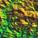
Highly detailed terrain mesh of the Namcha Barwa area, N29�-31� E94�-96�. The files in this package are based on Shuttle Radar (SRTM) Version 2 data but with many of the void areas, especially the most significant sections, filled with elevation data generated from topographic maps by Jonathan de Ferranti. While Jonathan's work is unrelated to flight simulation he kindly gave me permission to compile his data for use in FS. The result is a wonderful improvement in detail and accuracy over any existing mesh file, freeware or commercial, based on SRTM or DTED data alone. Due to the large area of the Himalayas I've compiled the source data as two separate series: the "Himalayan Peaks" series covers prominent mountains and ranges in higher detail and locally overrides any existing LOD9 terrain mesh. In addition, a LOD9 "base mesh" series covering the entire Himalayas will be available for those who do not yet have an add-on terrain mesh of these beautiful mountains.
| Filename: |
fs_him_03.zip |
| License: |
Freeware, limited distribution |
| Added: |
18th February 2006, 23:15:17 |
| Downloads: |
12139 |
| Author: |
Holger Sandmann and Jonathan de Ferranti |
| Size: |
15451kb |
|
|
|
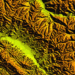
File Description:
Highly detailed terrain mesh of the Annapurna area, N28-30 E83-85. The files in this package are based on Shuttle Radar (SRTM) Version 2 data but with many of the void areas, especially the most significant sections, filled with elevation data generated from topographic maps by Jonathan de Ferranti. While Jonathan's work is unrelated to flight simulation he kindly gave me permission to compile his data for use in FS. The result is a wonderful improvement in detail and accuracy over any existing mesh file, freeware or commercial, based on SRTM or DTED data alone.
Due to the large area of the Himalayas I've compiled the source data as two separate series: the "Himalayan Peaks" series covers prominent mountains and ranges in higher detail and locally overrides any existing LOD9 terrain mesh. In addition, a LOD9 "base mesh" series covering the entire Himalayas will be available for those who do not yet have an add-on terrain mesh of these beautiful mountains.
|
| Filename: |
fs_him_04.zip |
| License: |
Freeware, limited distribution |
| Added: |
29th May 2010, 08:59:29 |
| Downloads: |
10415 |
| Author: |
Holger Sandmann, Jonathan de Ferranti |
| Size: |
15427kb |
|
|
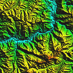
File Description:
Highly detailed terrain mesh of the Garhwal area, N30�-32� E78�-81�. The files in this package are based on Shuttle Radar (SRTM) Version 2 data but with many of the void areas, especially the most significant sections, filled with elevation data generated from topographic maps by Jonathan de Ferranti. While Jonathan's work is unrelated to flight simulation he kindly gave me permission to compile his data for use in FS. The result is a wonderful improvement in detail and accuracy over any existing mesh file, freeware or commercial, based on SRTM or DTED data alone. Due to the large area of the Himalayas I've compiled the source data as two separate series: the "Himalayan Peaks" series covers prominent mountains and ranges in higher detail and locally overrides any existing LOD9 terrain mesh. In addition, a LOD9 "base mesh" series covering the entire Himalayas will be available for those who do not yet have an add-on terrain mesh of these beautiful mountains.
| Filename: |
fs_him_05.zip |
| License: |
Freeware, limited distribution |
| Added: |
18th February 2006, 23:16:47 |
| Downloads: |
10071 |
| Author: |
Holger Sandmann and Jonathan de Ferranti |
| Size: |
28382kb |
|
|
|
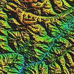
File Description:
Highly detailed terrain mesh of the Jammu and Kashmir areas, N31-36 E76-78. The files in this package are based on Shuttle Radar (SRTM) Version 2 data but with many of the void areas, especially the most significant sections, filled with elevation data generated from topographic maps by Jonathan de Ferranti. While Jonathan's work is unrelated to flight simulation he kindly gave me permission to compile his data for use in FS. The result is a wonderful improvement in detail and accuracy over any existing mesh file, freeware or commercial, based on SRTM or DTED data alone.
Due to the large area of the Himalayas I've compiled the source data as two separate series: the "Himalayan Peaks" series covers prominent mountains and ranges in higher detail and locally overrides any existing LOD9 terrain mesh. In addition, a LOD9 "base mesh" series covering the entire Himalayas will be available for those who do not yet have an add-on terrain mesh of these beautiful mountains.
|
| Filename: |
fs_him_06.zip |
| License: |
Freeware, limited distribution |
| Added: |
29th May 2010, 08:55:43 |
| Downloads: |
9606 |
| Author: |
Holger Sandmann, Jonathan de Ferranti |
| Size: |
53444kb |
|
|
|
File Description:
Highly detailed terrain mesh of the Karakoram area, N35-37 E73-77. The files in this package are based on Shuttle Radar (SRTM) Version 2 data but with many of the void areas, especially the most significant sections, filled with elevation data generated from topographic maps by Jonathan de Ferranti. While Jonathan's work is unrelated to flight simulation he kindly gave me permission to compile his data for use in FS. The result is a wonderful improvement in detail and accuracy over any existing mesh file, freeware or commercial, based on SRTM or DTED data alone.
Due to the large area of the Himalayas I've compiled the source data as two separate series: the "Himalayan Peaks" series covers prominent mountains and ranges in higher detail and locally overrides any existing LOD9 terrain mesh. In addition, a LOD9 "base mesh" series covering the entire Himalayas will be available for those who do not yet have an add-on terrain mesh of these beautiful mountains.
|
| Filename: |
fs_him_07.zip |
| License: |
Freeware, limited distribution |
| Added: |
30th May 2010, 09:56:27 |
| Downloads: |
9420 |
| Author: |
Holger Sandmann, Jonathan de Ferranti |
| Size: |
39503kb |
|
|
|
File Description:
Highly detailed terrain mesh of the Tirich Mir and Pamir areas, N36-39 E71-74. The files in this package are based on Shuttle Radar (SRTM) Version 2 data but with many of the void areas, especially the most significant sections, filled with elevation data generated from topographic maps by Jonathan de Ferranti. While Jonathan's work is unrelated to flight simulation he kindly gave me permission to compile his data for use in FS. The result is a wonderful improvement in detail and accuracy over any existing mesh file, freeware or commercial, based on SRTM or DTED data alone.
Due to the large area of the Himalayas I've compiled the source data as two separate series: the "Himalayan Peaks" series covers prominent mountains and ranges in higher detail and locally overrides any existing LOD9 terrain mesh. In addition, a LOD9 "base mesh" series covering the entire Himalayas will be available for those who do not yet have an add-on terrain mesh of these beautiful mountains.
|
| Filename: |
fs_him_08.zip |
| License: |
Freeware, limited distribution |
| Added: |
29th May 2010, 08:52:47 |
| Downloads: |
9059 |
| Author: |
Holger Sandmann, Jonathan de Ferranti |
| Size: |
49093kb |
|
  |


