|
AVSIM Library - Search Results
|
|
Login | Register | About logging in and out
|
|
Searching for: 'colorado' in Flight Simulator 2004 - Scenery and below.
|

|
|
|
|
|
|
File Description:
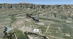
For helicopter lovers. In this scenery you will find several spots around Denver, CO. Updated Jeffco airport ("Rotors of the Rockies" hangars, new control tower, new main building, Fire station, McCair building, R22 School...), helipads in some airports in the near area, S&R Base, "The Fort" Restaurant, "Manor House" Restaurant, Mountain Resort, Swedish Medical Center, North Suburban Medical Center, St Anthony North Hospital...
| Filename: |
colorado_hops.zip |
| License: |
Freeware, limited distribution |
| Added: |
25th November 2005, 23:05:57 |
| Downloads: |
1388 |
| Author: |
Martin Lopez a.k.a. LBMartin |
| Size: |
10857kb |
|
|
File Description:
These files ADD 15 highly detailed lakes to Colorado. Although these lakes are specifically designed to show off their photo realistic detail when used in combination with 38.2m mesh, they work equally as well with the default mesh. All lake information was derived from detailed map data.
Included lakes are: the Antero, Eleven Mile, Spinney, Paonia, Lemon, Vallecito, Ruedi and Taylor Reservoirs, Cheesman Lake, Lake Grant, Peanut Lake, Meridian Lake, Nicholson Lake, Lake Irwin, and McPhee Reservoir, which is the second largest reservoir in the state.
| Filename: |
colorado_lakes_project_1.zip |
| License: |
Freeware |
| Added: |
8th February 2004, 23:33:51 |
| Downloads: |
5259 |
| Author: |
Carlyle Sharpe |
| Size: |
253kb |
|
|
|
File Description:
This project features the Blue Mesa Reservoir and the Black Canyon of the Gunnison and adds over 300 highly detailed lakes to the central portion of western Colorado. Three reservoirs, named for corresponding dams on the Gunnison River, form the heart of Curecanti National Recreation Area. Panoramic mesas, fjord-like reservoirs, and deep, steep and narrow canyons abound. Blue Mesa Reservoir is Colorado's largest body of water, and is the largest Kokanee Salmon fishery in the United States. Morrow Point Reservoir is the beginning of the Black Canyon of the Gunnison and below it is Crystal Reservoir.
These lakes are specifically designed to show off their photo realistic detail when used in combination with "FSGenesis-The Rockies 38.2m Terrain Mesh-Colorado" available as "fsg_dem38m_usrk_co.zip" at avsim.com, or comparable mesh. The free FSGenesis US National Landclass Project Beta 6 also adds beautifully to the landscape. These lakes work equally as well with the default mesh.
All lake information was projected from satellite imagery and compiled with a beta version of Jim Keir's "Slartibartfast" utility. Much thanks to Holger Sandmann and Jim Keir for their help and advice on interpreting the satellite data properly.
| Filename: |
colorado_lakes_project_2.zip |
| License: |
Freeware |
| Added: |
1st June 2004, 02:34:42 |
| Downloads: |
6032 |
| Author: |
Carlyle Sharpe |
| Size: |
332kb |
|
|
File Description:
This project features the lakes of Southwest Colorado, replaces the default Navajo Lake on the Colorado-New Mexico border, and adds over 300 highly detailed lakes to Colorado. They fit seamlessly with my "Colorado Lakes Project II" (colorado_lakes_project_2.zip) and "Colorado Lakes Project I" (colorado_lakes_project_1.zip) lakes. The original "Colorado Lakes Project I" is recommended to complete this package, as it contains McPhee, Lemon, and Vallecito Reservoirs.
These lakes are specifically designed to show off their photo realistic detail when used in combination with "FSGenesis-The Rockies 38.2m Terrain Mesh-Colorado" available as "fsg_dem38m_usrk_co.zip" at avsim.com, or comparable mesh. The free FSGenesis US National Landclass Project Beta 6 also adds beautifully to the landscape. These lakes work equally as well with the default mesh.
All lake information was projected from satellite imagery and compiled with a beta version of Jim Keir's "Slartibartfast" utility.
| Filename: |
colorado_lakes_project_3.zip |
| License: |
Freeware |
| Added: |
3rd June 2004, 21:54:46 |
| Downloads: |
4993 |
| Author: |
Carlyle Sharpe |
| Size: |
444kb |
|
|
File Description:
This project features the lakes of North Central Colorado, replaces all of the prominent reservoirs and lakes of the region (Dillon, Green Mountain, Granby, Williams Fork, and more), and adds over 500 highly detailed lakes to Colorado. They fit seamlessly with my "Colorado Lakes Project III" (colorado_lakes_project_3.zip), "Colorado Lakes Project II" (colorado_lakes_project_2.zip) and "Colorado Lakes Project I" (colorado_lakes_project_1.zip) lakes.
These lakes are specifically designed to show off their photo realistic detail when used in combination with "FSGenesis-The Rockies 38.2m Terrain Mesh-Colorado" available as "fsg_dem38m_usrk_co.zip" at avsim.com, or comparable mesh. The free FSGenesis US National Landclass Project Beta 6 also adds beautifully to the landscape. These lakes work equally as well with the default mesh.
All lake information was projected from satellite imagery and compiled with a beta version of Jim Keir's "Slartibartfast" utility.
| Filename: |
colorado_lakes_project_4.zip |
| License: |
Freeware |
| Added: |
10th June 2004, 04:27:10 |
| Downloads: |
4811 |
| Author: |
Carlyle Sharpe |
| Size: |
743kb |
|
|
File Description:
This scenery adds a highly detailed terminal replacement along with parking spots, vehicles, and more. The RWY-12 Libraries must be installed for this to work.
| Filename: |
kcos_full_v1.zip |
| License: |
Freeware |
| Added: |
9th March 2007, 22:46:35 |
| Downloads: |
4740 |
| Author: |
Brandon DePalo / Watsup Sceneries |
| Size: |
1565kb |
|
|
Images related to this file:
|
File Description:
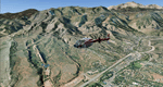
This region covers the area between Denver and Colorado Springs. It extends my Denver scenery to the south.
Just north of Colorado Springs you can see the widespread United States Air Force Academy which, with it's
many buildings, covers a huge area of 18.000 acres. The Academy Airfield (KAFF) which lays in the northeastern
corner of the area is used for training cadets in airmanship courses, including parachute training,
soaring and powered flight.
High resolution versions of this scenery for FS9 and FSX (much sharper, but larger and multiple downloads)
are available at www.blueskyscenery.com/GNB_South2East.html . The screenies are taken from the high-res versions,
so expect this version to be slightly more blurry. YourDonation@Work: Dedicated to Robin and Raymond.
|
| Filename: |
gnb_south2east_2010_lr.zip |
| License: |
Freeware, limited distribution |
| Added: |
3rd February 2010, 02:09:59 |
| Downloads: |
2148 |
| Author: |
Gottfried Razek - blueskyscenery.com |
| Size: |
99241kb |
|
|
Images related to this file:
|
File Description:
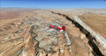
Colorado Springs South (KCOS), Colorado, Photo-Scenery (FS9 & FSX)
This region covers the area of Colorado Springs. Just west of the city you can fly around Pikes Peak. At 14.115ft it is the easternmost of Colorado's 54 fourteeners. Northwest of the city lies the Garden Of Gods with its many vertical rock formations. They are made of sedimentary beds red and white sandstones, conclomerates and limestone that were deposited horizontally but have been tilted vertically and faulted by the immense mountain building forces caused by the uplift of the Pikes Peak massiv. Deep within Chayenne Mountain is the North American Aerospace Defense Command's (NORAD) main technical facility which collects and evaluates data from a worldwide system of satellites, radars and other sensors.
High resolution versions of this scenery for FS9 and FSX (much sharper, but larger and multiple downloads) are available at www.blueskyscenery.com/GNB_South3East.html . The screenies are taken from the high-res versions, so expect this version to be slightly more blurry. YourDonation@Work: Dedicated to Veit and Hector.
|
| Filename: |
gnb_south3east_2010_lr.zip |
| License: |
Freeware, limited distribution |
| Added: |
5th February 2010, 16:30:42 |
| Downloads: |
1937 |
| Author: |
Gottfried Razek, blueskyscenery.com |
| Size: |
97923kb |
|
|
Images related to this file:
|
File Description:
Comb Ridge, Rock Point (49AZ), Utah/Arizona, Photo-Scenery (FS9 & FSX)
This scenery extends my Monument Valley scenery to the east. It covers the area between the San Juan River in the north down to Rock Point, AZ (49AZ). Most of the scenery lies on the Navajo Nation Reservation. It completes the southeastern corner of Utah and paves our way into Colorado.
High resolution versions of this scenery for FS9 and FSX (much sharper, but larger and multiple downloads) are available at www.blueskyscenery.com/CNY_South3West6.html . The screenies are taken from the high-res versions, so expect this version to be slightly more blurry. Thanks to Joop Mak for providing custom AFCADs that correct airport layouts so that they align with the photo-textures! They are available at www.blueskyscenery.com/AFCADs.html . YourDonation@Work: Dedicated to Olivier, Kevin and Ruben.
|
| Filename: |
cny_south3_2010_lr.zip |
| License: |
Freeware, limited distribution |
| Added: |
9th April 2010, 21:57:41 |
| Downloads: |
1325 |
| Author: |
Gottfried Razek, blueskyscenery.com |
| Size: |
93174kb |
|
|
File Description:
This changes the FS9 default Crawford, Colorado 99V airport from a 25 x 5200 ft gravel strip to more like it is today with most of its buildings and greatly changed runway-taxiway structure. It also adds Crawford Reservior SE of the airport and a small pond on the airport.
This is a replacement upload for 99Vaprt.zip that had the wrong texture folder in it. Simply download this and follow the improved installation instructions. You need not bother to remove the wrong textures you may have installed from the original upload.
| Filename: |
99vaprt_139482.zip |
| License: |
Freeware |
| Added: |
21st April 2004, 18:32:02 |
| Downloads: |
1213 |
| Author: |
Larry Costa |
| Size: |
1022kb |
|
  |


