|
AVSIM Library - Search Results
|
|
Login | Register | About logging in and out
|
|
Searching for: 'canyon ' in AVSIM File Library and below.
|

|
|
|
|
|
|
File Description:
The Flight Simulator default scenery has no lakes for the Beartooth Mountains of south-central Montana and adjacent Wyoming. Streams and roads follow unnatural paths up and down mountainsides and valley and canyon walls. These modifications add more than 1,150 lakes and ponds to the Beartooth Mountain landscape and major streams and highways are more accurately located. Some secondary and other roads and the Red Lodge ski area have been added. Addon 38.2m mesh such as the excellent FSGenesis Rocky Mountains freeware is necessary to properly view these modifications.
| Filename: |
beartooth_lakes_v1.zip |
| License: |
Freeware, limited distribution |
| Added: |
25th April 2004, 20:48:35 |
| Downloads: |
3152 |
| Author: |
Wilfred Husted |
| Size: |
110kb |
|
|
File Description:
This is a repaint of the FSD Bell 206B (3) helicopter in the livery of "Papillon Grand Canyon" fro FS9 (FS2004) only. This is a complete package and no other files are required for its use. Installation, Distribution and contact details for me are found in the Read Me file.
| Filename: |
bell_206b_111.zip |
| License: |
Freeware, limited distribution |
| Added: |
7th January 2012, 17:13:45 |
| Downloads: |
219 |
| Author: |
Tony Cannon, FSD Team |
| Size: |
5865kb |
|
|
|
File Description:
Scenery adding the Blue Canyon Wind Farm (Phase 1) north of Lawton, Oklahoma with antimated windmills and upgrading the nearby Jennings Ranch and airfield (OL09). This scenery was created with Airport Design Editor, utilizes an antimated windmill model posted at the FS Developer Community by hcornea, and has been tested using Ultimate Terrain X.
| Filename: |
blue_canyon_wind_farm.zip |
| License: |
Freeware |
| Added: |
28th October 2008, 20:40:19 |
| Downloads: |
605 |
| Author: |
Art Poole |
| Size: |
335kb |
|
|
Images related to this file:
|
File Description:
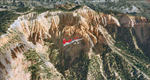
Bryce Canyon National Park (KBCE), Utah, Photo-Scenery (FS9 & FSX)
Despite its name, Bryce Canyon is not actually a canyon that was formed by a river, but rather a giant natural cliff shaped through erosion by wind, water, and ice. Bryce is distinctive due to its geological formations, delicate and colorful pinnacles called hoodoos that are up to 200ft high. The bizarre forms and red, orange and white colors of the rocks provide spectacular views. Unfortunately the hoodoos are too small for the elevation mesh in flight simulator. But you can enjoy the colors and shape of the cliffs. The cliffs in main region of the park, just south of the airport are partly covered
by snow. But on the southern and western part of the plateau you can enjoy them free of snow. Bryce Canyon is named after the Mormon pioneer Ebenezer Bryce who settled in this area in the 1850s. It was designated as a national park in 1928.
Bryce Canyon Airport (KBCE) just handles small aircraft on a daily basis. But is was actually built to handle larger aircraft in case of emergency. And so on Oct.6th 2000 an American Airlines MD-82 from Denver to Los Angeles made a successful emergency landing after reporting smoke in the cockpit and a loss of cabin pressure.
High resolution versions of this scenery for FS9 and FSX (much sharper, but larger and multiple downloads)are available at www.blueskyscenery.com/CNY_South2West4.html . The screenies are taken from the high-res versions, so expect this version to be slightly more blurry. Thanks to Joop Mak for providing a custom AFCADs that correct airport layouts so that they align with the photo-textures! They are available here: www.blueskyscenery.com/AFCADs.html . YourDonation@Work: Dedicated to Michael, Pat and Keith.
|
| Filename: |
cny_south2west4_2010_lr.zip |
| License: |
Freeware, limited distribution |
| Added: |
7th March 2010, 11:17:56 |
| Downloads: |
2163 |
| Author: |
Gottfried Razek, blueskyscenery.com |
| Size: |
98666kb |
|
|
File Description:
These little camps in the Bell Island, Alaska area are the first in a group of fictional sceneries covering Southeast AK. Should work fine with or without Eddy Denny's terrain mesh. I hope you enjoy them as much as I have.
Menu entries on the Add-on Scenery menu will get you to the starting points. Requires trees_v3 from Garrish Gray. Each includes a beach and water start. They make for nice hops to deliver hunters, fisherman, tourists, and supplies from Wrangell, or Ketchikan, AK.
| Filename: |
canyon_lakes_camps.zip |
| License: |
Freeware |
| Added: |
16th January 2004, 21:06:01 |
| Downloads: |
2193 |
| Author: |
Todd Hudgel |
| Size: |
1589kb |
|
|
File Description:
Canyon-Country USA is a flightplan through America�s beautiful canyons
and mountains of the southwest. It was designed to fly slow & low
(small/medium propeller planes recommended).
Many famous places and National Parks are directly enroute.
The flightplan is a roundtrip from/to North Las Vegas [KVGT]
with a total of 805nm.
| Filename: |
canyon-country.zip |
| License: |
Freeware, limited distribution |
| Added: |
24th March 2006, 03:09:02 |
| Downloads: |
1921 |
| Author: |
Andreas Trawny |
| Size: |
871kb |
|
|
Images related to this file:
|
File Description:
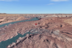
This is a re-upload of a package that was corrupted during the crash of the AVSIM library. This is the fourth package of the Arches/Canyonlands area. It covers the area southwest and including the confluence of the Colorado and Green Rivers. From there you can fly down Cataract Canyon which is famed for its premium whitewater rafting oportunities. Or explore the Maze (the area west of the Green and north of the Colorado River) with it's labyrinth of canyons and colorful sandstone formations. The scenery extends west to Hite (UT03) on Lake Powell. Brings the total Southern Utah coverage to 14.000 sq km in 4.7m/pix quality. YourDonation@Work: Dedicated to Patrick, Hideyuki and Art. Thanks!
|
| Filename: |
cny_southwest2009_lr.zip |
| License: |
Freeware, limited distribution |
| Added: |
31st December 2009, 22:33:46 |
| Downloads: |
2051 |
| Author: |
Gottfried Razek - blueskyscenery.com |
| Size: |
97965kb |
|
|
File Description:
Good to have LAGO FSSE.
| Filename: |
canyonchall.zip |
| License: |
Freeware |
| Added: |
23rd August 2002, 22:59:15 |
| Downloads: |
293 |
| Author: |
pinokio |
| Size: |
3kb |
|
|
File Description:
This project features the Blue Mesa Reservoir and the Black Canyon of the Gunnison and adds over 300 highly detailed lakes to the central portion of western Colorado. Three reservoirs, named for corresponding dams on the Gunnison River, form the heart of Curecanti National Recreation Area. Panoramic mesas, fjord-like reservoirs, and deep, steep and narrow canyons abound. Blue Mesa Reservoir is Colorado's largest body of water, and is the largest Kokanee Salmon fishery in the United States. Morrow Point Reservoir is the beginning of the Black Canyon of the Gunnison and below it is Crystal Reservoir.
These lakes are specifically designed to show off their photo realistic detail when used in combination with "FSGenesis-The Rockies 38.2m Terrain Mesh-Colorado" available as "fsg_dem38m_usrk_co.zip" at avsim.com, or comparable mesh. The free FSGenesis US National Landclass Project Beta 6 also adds beautifully to the landscape. These lakes work equally as well with the default mesh.
All lake information was projected from satellite imagery and compiled with a beta version of Jim Keir's "Slartibartfast" utility. Much thanks to Holger Sandmann and Jim Keir for their help and advice on interpreting the satellite data properly.
| Filename: |
colorado_lakes_project_2.zip |
| License: |
Freeware |
| Added: |
1st June 2004, 02:34:42 |
| Downloads: |
6032 |
| Author: |
Carlyle Sharpe |
| Size: |
332kb |
|
|
Images related to this file:
|
File Description:
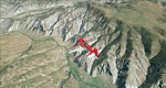
To explore this region depart from Eagle County Regional Airport (KEGE) which is a popular regional airport used in winter to transport skiers to nearby Vail. Northwest of the airport you can see the pit gypsum mine of American Gypsum which produces a variety of wallboard products. When you fly to the west and along the Eagle River, you soon pass its confluence with the Colorado River. Further west you can fly along Glennwood Canyon and finally reach Glennwood Springs where the Colorado meets the Roaring Fork River. Here you can turn south and fly direct Glenwood Springs Airport (KGWS) which lies south of the city. This scenery brings you another 3.500 sq km of beautiful Colorado in 4.7m/pix quality.
High resolution versions of this scenery for FS9 and FSX (much sharper, but larger and multiple downloads) are available at www.blueskyscenery.com/GNB_SouthWest2.html . The screenies are taken from the high-res versions, so expect this version to be slightly more blurry. YourDonation@Work: Dedicated to Alain and James.
|
| Filename: |
gnb_southwest2_2010_lr.zip |
| License: |
Freeware, limited distribution |
| Added: |
30th January 2010, 17:01:49 |
| Downloads: |
2649 |
| Author: |
Gottfried Razek - blueskyscenery.com |
| Size: |
96052kb |
|
  |


