
Where Flight Simulation Enthusiasts Gather from Around the World!
AVSIM Library - Search Results

| Category: Navigation and ATC - Navigation | |
| Israel IFR Charts |

|
File Description:
Contains three charts for IFR flying to and within Israel: low-level, high-level, and Tel Aviv terminal area. Charts are in Adobe Acrobat format (PDF) and have been cropped to fit Israel and its immediate environs on one sheet of paper. Source: Europe/North Africa/Middle East (ENAME) enroute charts L-16, H-13, and T-2, supplied online by the National Geospatial-Intelligence Agency.
| Filename: | Israel_IFR_Charts.zip |
| License: | Freeware |
| Added: | 7th August 2005, 23:51:56 |
| Downloads: | 719 |
| Author: | David Wilson-Okamura |
| Size: | 9.94 MB |
| Category: Miscellaneous Files - Miscellaneous Files | |
| QNH conversion table |
|
File Description:
Table to convert altimeter settings from metric to imperial. Usage is simple: millibars (mb) and hectopascals (hPa) are in one column, equivalent inches of mercury (Hg) are in the other column. Fits on one page. Two formats: Microsoft Word (.doc) and Adobe Acrobat (PDF).
| Filename: | QNH_conversion_table.zip |
| License: | Freeware |
| Added: | 1st August 2005, 23:32:16 |
| Downloads: | 674 |
| Author: | David Wilson-Okamura |
| Size: | 23.47 KB |
| Category: Flight Simulator 2004 - Miscellaneous Files | |
| Default Seaplane Bases in FS2004 |
|
File Description:
A sortable, Excel-format list of all the default seaplane bases in FS2004. Now you know where they are! Unfortunately, they are all in the United States.
| Filename: | Default_Seaplane_Bases_in_FS2004.zip |
| License: | Freeware |
| Added: | 29th April 2005, 00:08:21 |
| Downloads: | 1,673 |
| Author: | David Wilson-Okamura |
| Size: | 31.56 KB |
| Category: Navigation and ATC - Navigation | |
| Israel CVFR waypoints |
|
File Description:
All VFR in the state of Israel is conducted under the CONTROL of ATC; hence the acronym "CVFR" for "Controlled Visual Flight Rules." Israel has a special set of waypoints for CVFR, which do not appear in the standard GPS. The charts which do show these waypoints are in Hebrew. I do not read Hebrew, but Yuval Elbaz provided me with some data that translates the Hebrew names into Roman characters. Using this data, I have created a file which will put the waypoints into your Flight Simulator, so that they show up on your map and GPS.
| Filename: | Israel_CVFR_waypoints.zip |
| License: | Freeware |
| Added: | 1st August 2005, 23:33:00 |
| Downloads: | 749 |
| Author: | David Wilson-Okamura |
| Size: | 7.1 KB |
| Category: AVSIM File Library - Navigation and ATC | |
| Israel CVFR charts for FSM Moving Map |
|
File Description:
The two charts included here cover northern and southern Israel and show the required waypoints and flight paths for Controlled VFR (CVFR). They are calibrated for use in FSM Moving Map (FSMMM) by Rana Hossain. Calibration was performed primarily using the marked intersections of latitude and longitude lines. I am not entirely satisfied with the results. In most places, the accuracy seems to be off by about one mile. I do not know if this is my fault, or simply a limitation of the original map.
| Filename: | Israel_CVFR_charts_for_FSM_Moving_Map.zip |
| License: | Freeware |
| Added: | 2nd August 2005, 02:35:05 |
| Downloads: | 1,387 |
| Author: | David Wilson-Okamura |
| Size: | 3.75 MB |
| Category: Flight Simulator 2004 - Panels | |
| Streamlined panel for Grumman Goose G-21 |
|
File Description:
This panel streamlines the cockpit and virtual cockpit (VC) views in Lynn and Bill Lyons' Grumman Goose G-21 (cc9g21f2.zip). Why mess with perfection, you might ask? I like the Goose a lot: it's elegant, versatile, and has great views for VFR sightseeing. But on my system, the virtual cockpit's a bit sluggish. There's nothing wrong here with the airplane: it's just what happens when you try to run a complex piece of software on old hardware. Rather than give up, I decided to reduce the number of gauge objects, first in the cockpit (which I don't use very much anyway) and then in the virtual cockpit (which is where you should be flying this great old bird anyway). I also eliminated some of the hotspots. With fewer gauge objects, there are more system resources left over for the sim. The result, on my system, is smoother flying. While I was at it, I also replaced the magnetic compass with a VOR gauge. I know that's unrealistic, but that's what I did.
| Filename: | Streamlined_panel_for_Grumman_Goose_G21.zip |
| License: | Freeware |
| Added: | 13th November 2005, 23:12:02 |
| Downloads: | 1,237 |
| Author: | David Wilson-Okamura |
| Size: | 3.5 KB |
| Category: Flight Simulator X - Aircraft Repaints, Textures and Modifications | |
| Arado Ar-196 |
|
File Description:
The purpose of this package is to make the Alphasim Arado Ar-196, now freeware, usable in FSX. What needs to be done? First, we need to replace the gauges; the old ones don't work. I have done this for the virtual cockpit, but the 2D cockpit needs some work (which I am leaving to someone else). Second, we need to use some different sounds; the old ones don't exist in FSX. Third, we need a thumbnail image for the Aircraft selection menu. These three items are provided here: new panel.cfg, new sound.cfg, and a thumbnail. In addition, you'll also need the original package for FS2004 (ar196_fs9.zip) and a freeware gauge set by Hauke Keitel (kedigau_ud2.zip). Instructions for putting it all together are provided here in readme.txt.Also requires:
1. ar196_fs9.zip
2. kedigau_ud2.zip
| Filename: | Arado_Ar196.zip |
| License: | Freeware |
| Added: | 13th July 2008, 03:48:21 |
| Downloads: | 1,735 |
| Author: | David Wilson-Okamura |
| Size: | 17.62 KB |
| Category: Flight Simulator X - Scenery | |
| List of Western Kansas Airfields |
|
File Description:
This is just a printable list of all the airfields in Steve Ziegler's "Western Kansas Airfields" scenery for FSX. Page one orders the airfields by name; page two orders them by ICAO code. Two versions are included, one in Word format, the other in portable document format (PDF).
| Filename: | List_of_Western_Kansas_Airfields.zip |
| License: | Freeware |
| Added: | 15th September 2008, 23:05:07 |
| Downloads: | 295 |
| Author: | David Wilson-Okamura |
| Size: | 33.57 KB |
| Category: Navigation and ATC - Navigation | |
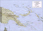
| Papua New Guinea charts 1 of 3 |
|
Images related to this file:
File Description:

Calibrated for FSMap, but scanned images can be used in other map software, such as FSM Moving Map (FSMMM) by Rana Hossain. Chart source: Topographic Maps U.S. Army Map Service, Series T504, original scale 1:250,000, date 1964-. Courtesy of the University of Texas Libraries, The University of Texas at Austin. Missing: I could not find equivalent charts for New Britain; for this island, a lower-quality chart is included.
| Filename: | Papua_New_Guinea_charts_1_of_3.zip |
| License: | Freeware |
| Added: | 5th June 2010, 03:40:04 |
| Downloads: | 1,213 |
| Author: | David Wilson-Okamura |
| Size: | 34.25 MB |
| Category: Navigation and ATC - Navigation | |
| Papua New Guinea charts 3 of 3 |
|
Images related to this file:
File Description:
Re-upload. Calibrated for FSMap, but scanned images can be used in other map software, such as FSM Moving Map (FSMMM) by Rana Hossain. Chart source: Topographic Maps U.S. Army Map Service, Series T504, original scale 1:250,000, date 1964-. Courtesy of the University of Texas Libraries, The University of Texas at Austin. Missing: I could not find equivalent charts for New Britain; for this island, a lower-quality chart is included.
| Filename: | Papua_New_Guinea_charts_3_of_3.zip |
| License: | Freeware |
| Added: | 5th June 2010, 05:26:20 |
| Downloads: | 516 |
| Author: | David Wilson-Okamura |
| Size: | 35.88 MB |
© 2001-2026 AVSIM Online
All Rights Reserved
Privacy Policy |