
Where Flight Simulation Enthusiasts Gather from Around the World!
AVSIM Library - Search Results

| Category: Flight Simulator 2004 - Scenery | |
| Alps LOD10 Topo Mesh - Update 1 |

|
File Description:
Patch files to remove tall spike in terrain near Salzburg at N47 44´ E13 00´ and to add the missing/distorted peaks of La Grande Moucherolle at N45 00´ E5 34´ and Mont Aiguille at N44 50' E5 33'.
Requires the full version of our Alps LOD10 mesh files, alpse_fe.zip and alpsw_fe.zip. Source data by Jonathan de Ferranti, compiled for FS by Holger Sandmann. Fully compatible with FS2002. A big thank-you to those who reported the "Salzbug" and the missing peaks in the French Alps.
| Filename: | Alps_LOD10_Topo_Mesh__Update_1.zip |
| License: | Freeware, limited distribution |
| Added: | 9th February 2006, 15:02:59 |
| Downloads: | 32,355 |
| Author: | Holger Sandmann, Jonathan de Ferranti |
| Size: | 2.57 MB |
| Category: Flight Simulator 2004 - Scenery | |
| Alps LOD10 Topo Mesh - Switzerland and France |
|
Images related to this file:
File Description:
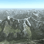
Yet another terrain mesh package of the European Alps? Well, this one is different in that it is NOT primarily based on the Shuttle Radar (SRTM) data with their incomplete coverage of prominent peaks and ridges. Instead, most of the source data for this project were developed over many months by Jonathan de Ferranti using detailed topographic maps. While Jonathan's work is unrelated to flight simulation he kindly gave me permission to compile his data for use in FS. The result is a wonderful improvement in detail and accuracy over any existing SRTM- or DTED-based mesh file, freeware or commercial (a link to an extensive set of screenshot comparisons is included in the read-me file).
I've compiled the source data at LOD10 (38-m) grid resolution because the coverage area is smaller than most existing mesh files. Thus, anyone can use these files without having to first uninstall their current mesh set. Also included are LOD9 and LO8 buffer mesh files. Note: if you own Switzerland Professional with its high-resolution terrain mesh then you don't need this package, at least not the Switzerland files!
| Filename: | Alps_LOD10_Topo_Mesh__Switzerland_and_France.zip |
| License: | Freeware, limited distribution |
| Added: | 30th May 2010, 09:51:03 |
| Downloads: | 58,986 |
| Author: | Holger Sandmann, Jonathan de Ferranti |
| Size: | 50.03 MB |
| Category: Flight Simulator 2004 - Scenery | |
| Alps LOD10 Topo Mesh - Austria and Italy |
|
Images related to this file:
File Description:
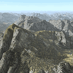
Yet another terrain mesh package of the European Alps? Well, this one is different in that it is NOT primarily based on the Shuttle Radar (SRTM) data with their incomplete coverage of prominent peaks and ridges. Instead, most of the source data for this project were developed over many months by Jonathan de Ferranti using detailed topographic maps. While Jonathan's work is unrelated to flight simulation he kindly gave me permission to compile his data for use in FS. The result is a wonderful improvement in detail and accuracy over any existing SRTM- or DTED-based mesh file, freeware or commercial (a link to an extensive set of screenshot comparisons is included in the read-me file).
I've compiled the source data at LOD10 (38-m) grid resolution because the coverage area is smaller than most existing mesh files. Thus, anyone can use these files without having to first uninstall their current mesh set. Also included are LOD9 and LO8 buffer mesh files. Note: if you own Austria Professional 2004 with its 1:50,000 scale terrain mesh then you don't need this package!
| Filename: | Alps_LOD10_Topo_Mesh__Austria_and_Italy.zip |
| License: | Freeware, limited distribution |
| Added: | 30th May 2010, 09:46:58 |
| Downloads: | 62,947 |
| Author: | Holger Sandmann, Jonathan de Ferranti |
| Size: | 73.32 MB |
| Category: Flight Simulator X - Scenery | |
| Nunavut Landscape - Canada |
|
File Description:
Elevation data (mesh-Lod10), land cover, water polygons, rivers, stream lines, lanes and shorelines around airports of Nunavut, Canada
| Filename: | Nunavut_Landscape__Canada.zip |
| License: | Freeware, limited distribution |
| Added: | 20th November 2010, 00:10:27 |
| Downloads: | 2,507 |
| Author: | Gilles Gauthier |
| Size: | 49.62 MB |
| Category: Flight Simulator X - Scenery | |
| Quebec Mesh (Lod10), between N56°-N57° and W66°-W77°, Prov. of Quebec (Canada) |
|
File Description:
FSX 38m (Lod10) terrain mesh files of territory included between N56°-N57° and W66°-W77°, province of Quebec, Canada.
| Filename: | Quebec_Mesh_Lod10_between_N56N57_and_W66W77_Prov_o.zip |
| License: | Freeware, limited distribution |
| Added: | 1st March 2008, 14:37:15 |
| Downloads: | 3,039 |
| Author: | Gilles Gauthier |
| Size: | 21.6 MB |
| Category: Flight Simulator X - Scenery | |
| Yukon Landscape - Canada |
|
File Description:
Elevation data (mesh-Lod10 - 38m), land cover, water polygons, rivers, stream lines, lanes and shorelines around airports of Yukon, Canada.
| Filename: | Yukon_Landscape__Canada.zip |
| License: | Freeware, limited distribution |
| Added: | 17th March 2011, 13:45:13 |
| Downloads: | 2,599 |
| Author: | Gilles Gauthier |
| Size: | 128.81 MB |
| Category: Flight Simulator X - Scenery | |
| NWT Landscape - Canada |
|
File Description:
Elevation data (mesh-Lod10 - 38m), land cover, water polygons, rivers, stream lines, lanes and shorelines around airports of Northwest Territories, Canada.
| Filename: | NWT_Landscape__Canada.zip |
| License: | Freeware, limited distribution |
| Added: | 9th February 2011, 17:43:21 |
| Downloads: | 3,349 |
| Author: | Gilles Gauthier |
| Size: | 89.42 MB |
| Category: Flight Simulator 2004 - Scenery | |
| Wairoa Airport - NZWO |
|
Images related to this file:
File Description:

Northern Hawkes' Bay. Made for Christian Stock's NZ mesh in the form of "Mountains of New Zealand" and topo in the form of "Lakes and Rivers of New Zealand".
| Filename: | Wairoa_Airport__NZWO.zip |
| License: | Freeware |
| Added: | 18th January 2011, 05:57:56 |
| Downloads: | 303 |
| Author: | Godfrey Tier |
| Size: | 1.74 MB |
| Category: Flight Simulator X - Scenery | |
| Labrador Landscape, Canada - 2/2 |
|
File Description:
Labrador (Province of Newfoundland and Labrador, Canada) elevation data (mesh-Lod10), land cover around airport, water polygons, rivers, stream lines, lanes and shorelines
| Filename: | Labrador_Landscape_Canada__22.zip |
| License: | Freeware, limited distribution |
| Added: | 24th May 2010, 11:36:42 |
| Downloads: | 2,345 |
| Author: | Gilles Gauthier |
| Size: | 58.49 MB |
| Category: Flight Simulator X - Scenery | |
| Labrador Landscape, Canada - 1/2 |
|
File Description:
Labrador (Province of Newfoundland and Labrador, Canada) elevation data (mesh-Lod10), land cover around airport, water polygons, rivers, stream lines, lanes and shorelines.
| Filename: | Labrador_Landscape_Canada__12.zip |
| License: | Freeware, limited distribution |
| Added: | 24th May 2010, 11:36:17 |
| Downloads: | 2,946 |
| Author: | Gilles Gauthier |
| Size: | 50.48 MB |
© 2001-2026 AVSIM Online
All Rights Reserved
Privacy Policy |