|
AVSIM Library - Search Results
|
|
Login | Register | About logging in and out
|
|
Searching for: 'airstrips' in AVSIM File Library and below.
|

|
|
|
|
|
|
File Description:
This package includes 13 detailed airstrips that are scattered within Nigeria. Enjoy!
| Filename: |
nigeria_airstrips_package_fsxp3d.zip |
| License: |
Freeware, limited distribution |
| Added: |
28th December 2019, 19:53:03 |
| Downloads: |
359 |
| Author: |
Raheem Adeleke |
| Size: |
457608kb |
|
|

|
File Description:
The OV-10 Bronco was a twin turboprop light attack and observation aircraft developed in the 1960’s. It proved very successful, with its capability of operating out of remote, unprepared airstrips whilst still carrying a significant payload and offering significant range and performance benefits.
As a result, a design was drawn up to modify the Bronco into a Cargo variant capable of carrying 8-12 combat troops or up to 4,500 pounds of cargo. Although never progressed beyond the design stage, it remains an interesting what-if of the aviation world.
This is a rework of Tim "Piglet" Conrad's FS9 original. Updated for FSX and P3D along with additional modifications. Please refer to the included manual for full list of changes and credits.
|
| Filename: |
n24_cv-10t_v1.0.zip |
| License: |
Freeware, limited distribution |
| Added: |
31st March 2017, 15:07:51 |
| Downloads: |
1154 |
| Author: |
Tristan "Novawing24" Ayton |
| Size: |
102758kb |
|
|
|
Other files which are related to, or may be required by, this file:
Images related to this file:
|
File Description:
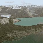
Glacier Bay v2 is a complete replacement of the default FS2004 landscape and scenery of more than 90,000 square kilometers (36,000 sq miles) of Southeast Alaska and adjacent areas of Yukon and British Columbia. File 2 of 2 (also requires glbayv2a.zip)
Landscape enhancements include high-resolution terrain mesh, detailed shorelines, rivers, lakes, and glaciers, and accurate land cover data with custom seasonal ground textures. Inland water bodies can be made to "freeze over" via an on/off switch. Other landmarks include the settlements of Juneau, Haines, Skagway, Yakutat, Atlin, and Carcross as well as road and railroad networks, cabins, lodges, and lighthouses. We modeled or enhanced 16 main airfields (plus one fictitious airstrip), 20 unlisted airstrips, 16 seaplane bases, and seven heliports. We've also included AI ship traffic in various locations as well as optional flightplans for GA and floatplane AI traffic.
Glacier Bay v2 is fully compatible with other third-party add-ons, including terrain mesh (FSGlobal, FS Genesis, etc.), ground textures (Ground Environment, BEV, FScene, etc.), and landscape enhancements (Ultimate Terrain Canada/Alaska, Misty Fjords, Tongass Fjords, Freight Dogs). A configurator panel (requires .Net Framework!) allows users to set compatibility options and to choose levels of scenery detail. We provide an autoinstaller and detailed documentation with a sectional map of the coverage area and a list of weblinks to real-world information.
For feedback and questions, please visit the Glacier Bay v2 support forum at http://forums.fsaddon.eu/viewforum.php?f=10. This project is a collaboration of nine FS developers from Germany, Austria, USA, and Canada, logging more than 1000 hours of work over the past 14 months. We acknowledge the kind support of FSAddon.com. However, this project is independent of any commercial company or product. Enjoy!
|
| Filename: |
glbayv2b.zip |
| License: |
Freeware, limited distribution |
| Added: |
28th May 2010, 19:36:31 |
| Downloads: |
40427 |
| Author: |
Holger Sandmann, Rainer Duda, Michael Eder, Scot Fraser, Manfred Herz, Jay Langham, Jon Patch, Larry Silsbee, and Jim Vile |
| Size: |
88054kb |
|
|
File Description:
This is Part 1 of the second release of the NASA elevation, this time with flattened airstrips and readjusted packages. This part also includes the AI files. The original release by Andre Meystre improved the terrain accuracy, especially near rivers, mountains and sea. This version has most strips updated and should also be very stable (no CTDs!) as it includes all necessary models and files. There are 2 parts to this update - make sure that you get both. Enjoy ;-)
| Filename: |
sea0801.zip |
| License: |
Freeware |
| Added: |
30th January 2013, 12:33:04 |
| Downloads: |
179 |
| Author: |
Jon Point, Andre Meystre |
| Size: |
87510kb |
|
|
File Description:
Ireland EICM Galway Airport. Galway airport is a small regional airport situated on the West coast of Ireland. The runway is 1289m(4230ft) in length and is therefore only suitable for GA and small jets. This scenery also includes EICA Connemara and the three airstrips of the Aran Islands, EIIM Inishmore, EIMN Inishmaan, and EIIR Inisheer. EICA Connemara plays host to the shortest scheduled airline service in the world, operated by Aer Arann, and appropriately using BN2 Islanders. In June of 1919, Alcock and Brown crashlanded their converted Vickers Vimy in a Connemara bog, having successfully completed the first non-stop transatlantic flight.
All the terminals and buildings are custom made and static aircraft add a sense of realism. The BGL files have been subdivided so the user can switch various elements of the scenery on or off according to preference. For added realism I have also added some sound effects, animations, people, grass, and rocks. Each airport has a complete set of night textures with wash lighting in the carparks and terminal areas.
The scenery has been primarily designed for VFR photographic scenery using 10m mesh, but will also work with the default terrain, although there are some variations with the default 38m mesh at Inishmore. All the five airports use objects from my Ireland Static object library, 3d aircrew and VFR trees. Full installation instructions are given in the Readme file. I hope you enjoy the scenery as much as I enjoyed making it.
| Filename: |
ireland_eicm_galway_airport.zip |
| License: |
Freeware |
| Added: |
5th November 2011, 22:04:59 |
| Downloads: |
3113 |
| Author: |
George Keogh |
| Size: |
79788kb |
|
|
File Description:
This is Part 2 of the second release of the NASA elevation, this time with flattened airstrips and readjusted packages. This part also includes the AI files.
The original release by Andre Meystre improved the terrain accuracy, especially near rivers, mountains and sea. This version has most strips updated and should also be very stable (no CTDs!) as it includes all necessary models and files. There are 2 parts to this update - make sure that you get both.
Enjoy ;-)
| Filename: |
sea0802.zip |
| License: |
Freeware |
| Added: |
24th December 2007, 14:46:47 |
| Downloads: |
514 |
| Author: |
Jon Point |
| Size: |
74911kb |
|
|
Other files which are related to, or may be required by, this file:
Images related to this file:
|
File Description:
Glacier Bay v2 is a complete replacement of the default FS2004 landscape and scenery of more than 90,000 square kilometers (36,000 sq miles) of Southeast Alaska and adjacent areas of Yukon and British Columbia. File 1 of 2 (also requires glbayv2b.zip)
Landscape enhancements include high-resolution terrain mesh, detailed shorelines, rivers, lakes, and glaciers, and accurate land cover data with custom seasonal ground textures. Inland water bodies can be made to "freeze over" via an on/off switch. Other landmarks include the settlements of Juneau, Haines, Skagway, Yakutat, Atlin, and Carcross as well as road and railroad networks, cabins, lodges, and lighthouses. We modeled or enhanced 16 main airfields (plus one fictitious airstrip), 20 unlisted airstrips, 16 seaplane bases, and seven heliports. We've also included AI ship traffic in various locations as well as optional flightplans for GA and floatplane AI traffic.
Glacier Bay v2 is fully compatible with other third-party add-ons, including terrain mesh (FSGlobal, FS Genesis, etc.), ground textures (Ground Environment, BEV, FScene, etc.), and landscape enhancements (Ultimate Terrain Canada/Alaska, Misty Fjords, Tongass Fjords, Freight Dogs). A configurator panel (requires .Net Framework!) allows users to set compatibility options and to choose levels of scenery detail. We provide an autoinstaller and detailed documentation with a sectional map of the coverage area and a list of weblinks to real-world information.
For feedback and questions, please visit the Glacier Bay v2 support forum at http://forums.fsaddon.eu/viewforum.php?f=10. This project is a collaboration of nine FS developers from Germany, Austria, USA, and Canada, logging more than 1000 hours of work over the past 14 months. We acknowledge the kind support of FSAddon.com. However, this project is independent of any commercial company or product. Enjoy!
|
| Filename: |
glbayv2a.zip |
| License: |
Freeware, limited distribution |
| Added: |
28th May 2010, 19:34:54 |
| Downloads: |
41157 |
| Author: |
Holger Sandmann, Rainer Duda, Michael Eder, Scot Fraser, Manfred Herz, Jay Langham, Jon Patch, Larry Silsbee, and Jim Vile |
| Size: |
57818kb |
|
|
Images related to this file:
|
File Description:
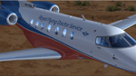
Royal Flying Doctors Services - VH-VSA. The Pilatus PC-24 long range jet is set to revolutionise aero medicine for the patients of the Royal Flying Doctor Service, ensuring better outcomes for people in WA. The RFDS will welcome the first of 3 new Pilatus PC-24 long range jet aircraft from 2017. The innovative aircraft will deliver increased fuel efficiency with twice the cruising speed of the PC-12. With an increased capacity to carry three stretchered patients, the ability to land on unpaved airstrips and shorter take off and landing capabilities, the PC-24 jets will be a game changer for the RFDS. Ultimately, it means we will be able to retrieve patients even more efficiently, and faster, from a greater number of locations around the state. Textures only. You need a legal copy of the IRIS PC-24.
|
| Filename: |
iris_pc-24_svj_vh-vsa.zip |
| License: |
Freeware |
| Added: |
29th April 2018, 16:25:35 |
| Downloads: |
923 |
| Author: |
Eberhard Haberkorn / IRIS Simulations |
| Size: |
44063kb |
|
|
Other files which are related to, or may be required by, this file:
- Detailed Terrain Features for Southern Africa (Download #170982)
- Land Class for Southern Africa, Update 1 (Download #171941)
- Detailed Terrain Features for Southern Africa, Update 3 (Download #173325)
- Detailed Terrain Features for Southern Africa, Update 2 (Download #172596)
- FACY - Stilbaai Airfield, South Africa (Download #181954)
- Detailed Terrain Features for Southern Africa, Update 1 (Download #172166)
- Land class for Southern Africa (Download #171046)
- Dam Walls for Southern Africa (Download #172176)
- Non-Airport Scenery for Southern Africa (Download #172598)
- Ysterplaat Airport (FAYP), South Africa (Download #175396)
- Robben Island Airstrip (AX78), Table Bay, South Africa (Download #172995)
- Stellenbosch Airport (FASH), South Africa (Download #173018)
- Arnot Power Station Airfield (FAAP), South Africa (Download #173328)
- Beaufort West Airfield (FABW), South Africa (Download #173517)
- Detailed Terrain Features for Southern Africa, Update 4 (Download #174826)
- Non-Airport Scenery for Southern Africa, Update 1 (Download #175147)
- Detailed Terrain Features for Southern Africa, Update 5 (Download #176374)
- Ermelo Airport (FAEO), South Africa (Download #176373)
- FAKT - Kitty Hawk Airfield - Boschkop, South Africa (Download #176245)
- Detailed Terrain Features for Southern Africa, Update 6 (Download #178457)
- FADB (Dwaalboom), AW15 (Batavia) Airstrips, South Africa (Download #177614)
- Middelburg Airfield (FAMB), South Africa (Download #179362)
- Detailed Terrain Features for Southern Africa, Update 7 (Download #179615)
- Inhambane International Airport (FQIN), Mozambique (Download #179792)
- Non-Airport Scenery for Southern Africa, Flamingo Bay Water Lodge, Mozambique (Download #181233)
- Detailed Terrain Features for Southern Africa, Update 8 (Download #181801)
- Detailed Terrain Features for Southern Africa, Update 9 (Download #183248)
- Detailed Terrain Features for Southern Africa, Update 10 (Download #184365)
- FALL - Lydenburg Airfield, South Africa (Download #184391)
Images related to this file:
|
File Description:
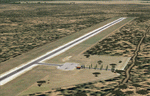
Dwaalboom and Batavia is Airstrips located in the Limpopo province of South Africa immediately east of the Waterberge. The Airfields are mostly used by visiting overseas hunters to the area.
|
| Filename: |
fsxworx26upd1.zip |
| License: |
Freeware |
| Added: |
10th June 2013, 20:32:48 |
| Downloads: |
1937 |
| Author: |
Hannes Steyn, Martin du Preez, Aeroworx |
| Size: |
34751kb |
|
|
Images related to this file:
File Description:
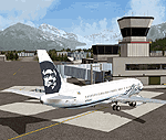
The Prudhoe Bay area of the Alaska north slope is dominated by all the equipment and machinery that is necessary for the extraction of oil and its transfer by the pipeline that reaches south to Valdez. Prudhoe Bay airport is now closed, and its replacement just to the south is Deadhorse PASC, with numerous storage, maintenance, and accomodation areas immediately to the north of the apron, and others adjacent to the road between the two. The runway is just under 6,500 feet with approach lights at both ends and ILS on 04 (true heading of 75 degrees). This scenery reflects the overall situation in 2011 and oil production facilities and buildings are included here. The airport buildings and those close to the airport are replicas of the real life buildings; while as distance increases the accuracy fades somewhat there are everywhere replica trucks and cross country vehicles that are true to life. Deadhorse handles around 7,000 passengers per month as staff are rotated in and out on Alaska Air and ERA flights and by oil company private flights. There are also freight flights to complement the trucking effort up the Dalton Highway. The Alaska Airlines terminal building and ERA (the red buildings nearby) are at one end of the apron, while at the other end is a very large and new green terminal, storage, hangar building built by the airport authority. All of the airport components, runways, taxiways, and aprons, are built up on a gravel base to raise them above the surrounding terrain that floods with melting snow, freezes, or dries out, according to the seasons. There are other new airstrips included here that serve the oil industry. Around 33 miles to the east is Badami PABP airport servicing a subsiduary oil producing area, with 5,000 feet of gravel runway. Some 28 miles to the west of Deadhorse is Ugnu-Kuparuk UBW with just over 6,000 feet of gravel (gravel in 2011, it is now asphalted) servicing oil production by Conoco Phillips, which uses 737's to fly staff in and out. A further 32 miles west is Alpine AK15 with 5,400 feet of gravel and also served by the Conoco Phillips 737's. To the south of Alpine and connected by road is the village of Nuiqsut. To the north of Alpine and reachable only by air in the delta of the Sagavanirktok River is CD-3, an oil collection and pump station area with another gravel runway of 3,000 feet. Other airstrips that were prviously posted are now updated, Nuiqsut and Oliktok. I experimented, but decided against trying to reproduce the several hundred miles of pipelines. The are new AI aircraft, and there are notes regarding downloading. There is a new "cement" texture (not its name, but used as that by SBuilder) for the built up gravel bases. It is slightly darker than the original but not so much that any previous use will be spoilt. You may wish to download my "Alaska Frozen Rivers and Lakes" which freezes lakes and the northern sea and makes them landable on wheels.
| Filename: |
prudhoe_bay_alaska.zip |
| License: |
Freeware, limited distribution |
| Added: |
19th December 2017, 00:38:06 |
| Downloads: |
539 |
| Author: |
Roger Wensley |
| Size: |
30174kb |
|
  |


