
Where Flight Simulation Enthusiasts Gather from Around the World!
AVSIM Library - Search Results

| Category: Flight Simulator 2004 - Scenery | |
| Grand Canyon Thermals and Tour plan |

|
File Description:
Grand Canyon soaring Tour. 230 Miles following the Canyon from Grand Canyon Natl Park (KGCN) to McCarran Intl (KLAS) in Las Vegas
Includes plan for Fs2004 and for FSNavigator and also thermals for the whole area.
| Filename: | Grand_Canyon_Thermals_and_Tour_plan.zip |
| License: | Freeware |
| Added: | 30th August 2005, 13:11:38 |
| Downloads: | 1,457 |
| Author: | Alejandro Villa |
| Size: | 686.56 KB |
| Category: Flight Simulator 2004 - Scenery | |
| Grand Canyon National Park NED Terrain Mesh |
|
File Description:
This mesh covers one of the most defining landscapes in the United States, The Grand Canyon.
Produced using NED 1arcsec/30m source data.
| Filename: | Grand_Canyon_National_Park_NED_Terrain_Mesh.zip |
| License: | Freeware, limited distribution |
| Added: | 8th May 2004, 18:09:02 |
| Downloads: | 9,744 |
| Author: | Tom Finley |
| Size: | 13.54 MB |
| Category: Flight Simulator 2004 - Scenery | |
| Glen Canyon / Lake Powell, Utah 38m Terrain Mesh |
|
File Description:
USGS SRTM30 1 arc-second, resampled to LOD10 (38.2 meters).
This high-resolution terrain mesh is centered at Glen Canyon
National Recreation Area in south-eastern Utah. Coverage area:
From West -111.6° to West -110.2° and North 36.8° to North 38.0°.
It includes the National Recreation Area with Lake Powell,
Navajo Mountain, the Henry Mountains, parts of Capitol Reef
National Park / Grand Staircase Escalante National Monument,
the town of Page in northern Arizona and surrounding areas.
| Filename: | Glen_Canyon__Lake_Powell_Utah_38m_Terrain_Mesh.zip |
| License: | Freeware, limited distribution |
| Added: | 25th January 2004, 20:30:45 |
| Downloads: | 5,418 |
| Author: | Andreas Trawny |
| Size: | 8.31 MB |
| Category: Flight Simulator 2004 - Scenery | |
| Page (KPGA), Lake Powell West, Utah/Arizona, Photo-Scenery (FS9 & FSX) |
|
Images related to this file:
File Description:
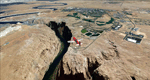
This scenery covers the western part of Lake Powell, the city of Page (KPGA), the Vermillion Cliffs, Glenn Canyon just south of Glenn Canyon Dam, the northern part of Marble Canyon, Paria Canyon, Cockscomb, etc, etc. Spectacular! To explore the scenery depart from Page Municipal Airport (KPGA). High resolution versions of this scenery for FS9 and FSX (much sharper, but larger and multiple downloads) are available at www.blueskyscenery.com/CNY_South3West3.html . The screenies are taken from the high-res versions, so expect this version to be slightly more blurry. YourDonation@Work: Dedicated to William, Veit and Michele.
| Filename: | Page_KPGA_Lake_Powell_West_UtahArizona_PhotoScener.zip |
| License: | Freeware, limited distribution |
| Added: | 3rd March 2010, 21:26:32 |
| Downloads: | 1,818 |
| Author: | Gottfried Razek - blueskyscenery.com |
| Size: | 92.41 MB |
| Category: Flight Simulator 2004 - Scenery | |
| Canyon Lake Camps |
|
File Description:
These little camps in the Bell Island, Alaska area are the first in a group of fictional sceneries covering Southeast AK. Should work fine with or without Eddy Denny's terrain mesh. I hope you enjoy them as much as I have.
Menu entries on the Add-on Scenery menu will get you to the starting points. Requires trees_v3 from Garrish Gray. Each includes a beach and water start. They make for nice hops to deliver hunters, fisherman, tourists, and supplies from Wrangell, or Ketchikan, AK.
| Filename: | Canyon_Lake_Camps.zip |
| License: | Freeware |
| Added: | 16th January 2004, 21:06:01 |
| Downloads: | 2,196 |
| Author: | Todd Hudgel |
| Size: | 1.56 MB |
| Category: Flight Simulator 2004 - Scenery | |
| High Canyon Camp |
|
File Description:
This little camp in the Ketchikan, Alaska area is part of a group of fictional sceneries covering Southeast AK. Should work fine with or without Eddy Denny's terrain mesh. I hope you enjoy them as much as I have.
Menu entries on the Add-on Scenery menu will get you to the starting points. Requires trees_v3 from Garrish Gray. Includes a short dirt strip, STOL planes only need apply. It makes for a nice hop from Ketchikan, AK, and due its proximity to Moudi Farm (Najis Bush Scenery), is a good weekend camping spot for farm residents and visitors. The old cabin is boarded up and has fallen into disuse, but the landing strip is in pretty good shape, and you will usually (okay always) find campers there. Fly on in, I'm sure you'll be welcome.
| Filename: | High_Canyon_Camp.zip |
| License: | Freeware |
| Added: | 16th January 2004, 21:11:31 |
| Downloads: | 1,628 |
| Author: | Todd Hudgel |
| Size: | 980.46 KB |
| Category: Flight Simulator 2004 - Scenery | |
| Hells Canyon, Oregon / Idaho SRTM30_1ArcSec Terrain Mesh |
|
File Description:
This 38m terrain mesh is centered in Hells Canyon of the Snake River
between Oregon and Idaho. Coverage area: From West 116.2° to West 117.1°
and North 45.0° to North 46.5°. It includes the City of Lewiston,
Hells Canyon National Recreation Area with Snake and Imnaha River,
Salmon River and the Seven Devils mountain peaks.
| Filename: | Hells_Canyon_Oregon__Idaho_SRTM30_1ArcSec_Terrain_.zip |
| License: | Freeware, limited distribution |
| Added: | 29th December 2003, 16:58:59 |
| Downloads: | 3,026 |
| Author: | Andreas Trawny |
| Size: | 6.16 MB |
| Category: Flight Simulator 2004 - Scenery | |
| Page, AZ - Lake Powell Photo Scenery |
|
File Description:
Photo scenery for the Page, AZ area with Lake Powell and the Glen Canyon Dam. Includes AI traffic, FS9 water for the lake and updated AFCAD.
| Filename: | Page_AZ__Lake_Powell_Photo_Scenery.zip |
| License: | Freeware |
| Added: | 4th February 2007, 21:56:21 |
| Downloads: | 1,690 |
| Author: | Kevin Burns |
| Size: | 27.67 MB |
| Category: Flight Simulator 2004 - Scenery | |
| Scenic Airport Series First Release- Tuweep, AZ (L50) |
|
File Description:
I am proud to announce the first release in my series of AFCAD2 Scenic airports. This series takes advantage of the AFCAD program and makes it a scenery tool as well as a facility tool. In addition, traffic has been added to the airport to make it more realistic, along with one historic aircraft doing touch and goes from 7 AM to 7 PM. This first release is of the Tuweep Airport in Tuweep, Arizona (L50). Nestled next to the Grand Canyon, this airport offers a great place for scenic VFR flying. Enjoy! NOTE: It is very important that you read the readme file enclosed.
| Filename: | Scenic_Airport_Series_First_Release_Tuweep_AZ_L50.zip |
| License: | Freeware, limited distribution |
| Added: | 11th November 2003, 06:00:59 |
| Downloads: | 1,634 |
| Author: | Jesse Elliott |
| Size: | 386.62 KB |
| Category: Flight Simulator 2004 - Scenery | |
| Grand Junction Update |
|
File Description:
FS2004 Scenery - Grand Junction Regional update. This is a flatten file for those running FS Genesis with the Grand Junction Regional scenery (kgjt_v1.zip). Flatten file by Ray Lunning, uploaded by John B. Loney, Jr.
| Filename: | Grand_Junction_Update.zip |
| License: | Freeware, limited distribution |
| Added: | 20th September 2008, 02:14:19 |
| Downloads: | 868 |
| Author: | John B. Loney, Jr. and Ray Lunning |
| Size: | 172.38 KB |
© 2001-2026 AVSIM Online
All Rights Reserved
Privacy Policy |