|
AVSIM Library - Search Results
|
|
Login | Register | About logging in and out
|
Searching for:
Name and/or Description matching 'Quebec Scenery'
Author matching 'Gilles Gauthier'
in Flight Simulator X - Scenery and below.
|

|
|
|
|
|
|
File Description:
This scenery replaces the FSX 'winter' water polygons by an iced cover for
lakes, rivers and St.Lawrence river of Province of Quebec, Canada, under N52.
Only compatible with Gilles Gauthier's Quebec mesh and landscape sceneries
and Jean-Pierre Fillion AI ships routes. (See www.quebecfsx.org).
| Filename: |
glacehiverquebec.zip |
| License: |
Freeware, limited distribution |
| Added: |
18th September 2013, 13:06:36 |
| Downloads: |
507 |
| Author: |
Gilles Gauthier and Jean-Pierre Fillion |
| Size: |
55451kb |
|
|
Images related to this file:
|
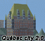
File Description:
Quebec city version 2.00 for Flight Simulator X.
FSX Scenery--Quebec City 2.0, Canada. Quebec city (Ville de Quebec in French) is the capital of the Canadian province of Quebec. This highly detailed scenery include more than 135 custom buildings. Come and see what Quebec City looks likes with its major landmarks in your flight simulator. Many new FSX features have been used to build this great scenery like animations and custom special effects. Also, see the CYQB airport scenery by Gilles Boily then enjoy flying in Quebec City. By Jean St-Cyr, Gilles Boily, Gilles Gauthier and Jean-Pierre Fillion.
This is and update version of Quebec city fsx scenery. Keep the first version since it is intended for low-end computers.
Thanks
Jean St-Cyr
|
| Filename: |
villedequebec_263518.zip |
| License: |
Freeware, limited distribution |
| Added: |
31st October 2009, 00:17:10 |
| Downloads: |
12798 |
| Author: |
Jean St-Cyr, Gilles Boily, Gilles Gauthier and Jean-Pierre Fillion |
| Size: |
66326kb |
|
|
File Description:
Addition of roads for the province of Quebec, Canada (for FSX only).
For best scenery, use with lakes, shorelines and rivers of the province of Quebec, Canada. (QCLacs_FSX_ (1to5) de5.zip - AVSIM file library)
| Filename: |
qcroutes_fsx.zip |
| License: |
Freeware, limited distribution |
| Added: |
8th March 2007, 14:20:13 |
| Downloads: |
7570 |
| Author: |
Gilles Gauthier |
| Size: |
7805kb |
|
|
File Description:
Re-uploaded file. Lakes, shorelines and rivers of the province of Quebec, Baie James hydroelectric complex territory, Canada (for FSX only)(range : N52-N55, W66-W80). For best rendering, use terrain mesh for the same territory of the province of Quebec (Canada) in LOD10 (Qc38mBJ_FSX_*de2.zip - 2 files - AVSIM library).
| Filename: |
qclacs_bj_fsx.zip |
| License: |
Freeware, limited distribution |
| Added: |
28th May 2010, 04:17:20 |
| Downloads: |
3837 |
| Author: |
Gilles Gauthier |
| Size: |
64748kb |
|
|
File Description:
Re-uploaded file. Lakes, shorelines and rivers of the province of Quebec, Canada - Territory included between N55-N57 and W66-W78(for FSX only).
| Filename: |
qclacs_bj1_fsx.zip |
| License: |
Freeware, limited distribution |
| Added: |
9th June 2010, 02:26:29 |
| Downloads: |
3393 |
| Author: |
Gilles Gauthier |
| Size: |
32460kb |
|
|
Other files which are related to, or may be required by, this file:
File Description:
Lakes, shorelines and rivers of the province of Quebec, Canada. (range : N45°-N52°, W55°-W80°).
| Filename: |
qclacs_fsx_1de5.zip |
| License: |
Freeware, limited distribution |
| Added: |
24th February 2007, 08:23:57 |
| Downloads: |
10619 |
| Author: |
Gilles Gauthier |
| Size: |
15313kb |
|
|
Other files which are related to, or may be required by, this file:
File Description:
Lakes, shorelines and rivers of the province of Quebec, Canada. (range : N45°-N52°, W55°-W80°).
| Filename: |
qclacs_fsx_2de5.zip |
| License: |
Freeware, limited distribution |
| Added: |
24th February 2007, 08:24:28 |
| Downloads: |
7196 |
| Author: |
Gilles Gauthier |
| Size: |
23365kb |
|
|
File Description:
Lakes, shorelines and rivers of the province of Quebec, Canada. (range : N45�°-N52�°, W55�°-W80�°).
| Filename: |
qclacs_fsx_3de5.zip |
| License: |
Freeware, limited distribution |
| Added: |
17th December 2009, 23:13:20 |
| Downloads: |
7271 |
| Author: |
Gilles Gauthier |
| Size: |
24448kb |
|
|
Other files which are related to, or may be required by, this file:
File Description:
Lakes, shorelines and rivers of the province of Quebec, Canada. (range : N45°-N52°, W55°-W80°).
| Filename: |
qclacs_fsx_4de5.zip |
| License: |
Freeware, limited distribution |
| Added: |
24th February 2007, 08:24:59 |
| Downloads: |
7047 |
| Author: |
Gilles Gauthier |
| Size: |
24758kb |
|
|
File Description:
Lakes, shorelines and rivers of the province of Quebec, Canada. (range : N45�°-N52�°, W55�°-W80�°).
| Filename: |
qclacs_fsx_5de5.zip |
| License: |
Freeware, limited distribution |
| Added: |
17th December 2009, 23:14:54 |
| Downloads: |
7896 |
| Author: |
Gilles Gauthier |
| Size: |
29195kb |
|
  |


